Can Anyone Here Read/Interpret a Property Land Survey?

nico08

Recycles dryer sheets
Joined
Feb 6, 2010
Messages
429
Hello:

I am trying to figure out the borders of my property. I have two surveys. I am trying to figure the distance from the exterior walls of the house to the end of my property line. The survey includes some measurements and angles, but does not give the distance between the exterior walls of the house and the end of the side property lines. The property is on a curved road, so the measurements are not for a square piece of property.

If you can read and interpret surveys please send me a private message (PM) and I will send you over a copy of the surveys. My username is midnighter777.

Thank you for your help.
 
This is just my opinion.... but I do not think that a survey showing your house has anything to do with where your property line is located...

There should be some reference mark, such as a stake etc. where you would start...

I guess you can make an estimate, but it would not hold up in a dispute..
 
The paper distance should match the measured distance, of the land anyway.

See your PM.

-CC
 
Last edited:
I think the stakes may have been moved.


there are many of them around, they can start from a different stake... nobody can move all of them...

This does cost you money as it has to be done by a licensed surveyor....
 
I think the stakes may have been moved.
Or they may be still there and you just don't see them :cool: ...

Our land was re-surveyed before we did our initial property line plantings, but over the years the one's in the front have been covered by turf (the one's in the back by the woods were larger, and are still visable).

If you can borrow a metal detector you might find the original stakes.
 
If you go to your county assessors and have them bring up the aerial of your property, they have software that can measure distances on the maps. don't know how accurate because of house overhangs on an aerial map.
 
Generally speaking, every peice of property is accompanied by a survey which indicates it's dimensions and location. The location, say the starting point of the dimensions of the property, is based on a known mark called a monument. If you decide to build a structure on this property, a surveyor and/or an architect will locate the structure based on local requirements such as setbacks, easements, right of ways, etc. You just can't put the building wherever you want. So, for the most part, the survey of your property should have all the dimensions required to show authorities where the structure is located on your property. Your local property appraisors office should be able to help you with this.
 
Last edited:
Get a surveyor to set the corners of the house.

When daughter remodeled her house we learned, much to our dismay, that the property line along the future garage was at a very slight angle off of perpendicular. It was necessary to adjust the foundation forms on that side. Thank heavens it was discovered before the concrete was poured.
 
Last edited:
Generally speaking, every peice of property is accompanied by a survey which indicates it's dimensions and location. The location, say the starting point of the dimensions of the property, is based on a known mark called a monument. If you decide to build a structure on this property, a surveyor and/or an architect will locate the structure based on local requirements such as setbacks, easements, right of ways, etc. You just can't put the building wherever you want. So, for the most part, the survey of your property should have all the dimensions required to show authorities where the structure is located on your property. Your local property appraisors office should be able to help you with this.

Depends where you live. In my town, property is not decribed in metes and bounds. If you go to the town clerk, my property (purchased from the local Native American tribe in 1639) is described as 'that area bounded by the property now or formerly owned by Smith, Jones and Miller, and the street'. That's all. We and the neighbors generally have agreement as to where our property begins and ends, but it is by no means clear on the land records.
 
Depends where you live. In my town, property is not decribed in metes and bounds. If you go to the town clerk, my property (purchased from the local Native American tribe in 1639) is described as 'that area bounded by the property now or formerly owned by Smith, Jones and Miller, and the street'. That's all. We and the neighbors generally have agreement as to where our property begins and ends, but it is by no means clear on the land records.

Wow gumby, that's different! Never heard of anything like that. My post was through real estate school, surveying class back in college and past experience. Guess my experience is not as well rounded as I thought. I never heard about land that was purchased from the American Indians and had never been surveyed and/or plotted and documented to paper as we know it today as a survey.
 
As a surveyor, I would hate to survey in the east. Metes and bounds or the "lands owned by Smith" would present many possibilities for conflicts between surveys. Abraham Lincoln's parents left Kentucky for Indiana because of a title/survey problem.

In states west of the 13 colonies, Kentucky, and Tennessee, surveying is generally easier- surveys generally began with square miles known as sections as part of the Public Land Survey System. Then subdivisions of sections were platted and lots were created in the cities and small towns. Rural areas are still described as part of the original sections. There is a good set of records filed at the county courthouses that surveyors use to determine the boundaries of properties.
 
It does get complicated. Here's a good example:

Our property description takes up a full page of small print, just to describe our lot. The description is based on a survey done before 1800 by John Nancarrow, a Revolutionary War veteran who received a land grant out here in Ohio. He never actually visited the area, but sold it in 1802, and his original surveyed 230 acres immediately began being subdivided.

The starting point of the legal description of our lot is as follows:
Commencing at an iron pipe where the South line of Nancarrows Survey No. 1747 intersects the boundary line between Hamilton and Clermont Counties, said pipe being South 71° 42' East, 209.15 feet from an old stone in the South line of said Survey, ...

So the first step is to find the remains of an iron pipe which has been rusting away for over 200 years. In order to determine that the spot of rust your metal detector finds is actually the right one, you need to find "an old stone" that is over 200 feet away. As it happens, that point today is in thick woods.

Complicated enough to best be left to professionals.:facepalm:
 
Chances are that stone is still there if its in thick woods. We find stones dating back to the 1840's in illinois. But your 200 year old pipe may be a pile of rust like you say.

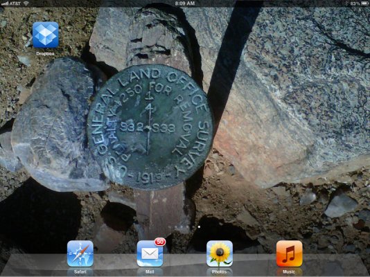
Here's an original survey stake set by US gov surveyors in Arizona - on the edge of a hiking trail. I made it my wallpaper on my iPad
 

Attachments

  • image-1246544980.jpg
    image-1246544980.jpg
    699.9 KB · Views: 9
IIRC, the 'four corners' of Utah, Arizona, Colorado and New Mexico are not where commonly thought to be and marked on the map.
 
There was a PBS show about the states.... and one of the programs was about how the states got their shapes...

It is surprising, but there are still arguments on which state some land is located... they had one part of the program where they were doing a survey and determined that the state line was off and some people living on the same street lived in different states.... one lady had the state line through her house (IIRC).....

Another problem that can arise is that the survey team finds the wrong stake.... this happened to my BIL.... there is enough fluff in the description that things can be off a bit.... but the survey seemed to be way off when you are buying 10 acres.... he decided to go out himself and finally found the correct stake and then all the measurements magically worked out.... also proved the neighbor was on his land.....

That series on PBS called "How the States Got Their Shapes" was one of the most interesting TV shows. It really held my interest. Wish they would show it again.
 
JOHNNIE36 said:
That series on PBS called "How the States Got Their Shapes" was one of the most interesting TV shows. It really held my interest. Wish they would show it again.

That's a great series. I couldn't wait until they showed it again. I bought the series on appletv.

The 4 corners monument story is interesting - it's approx 1800' from its intended position. But within acceptable tolerances considering the equipment and techniques used at the time, and generally in the position where the original monument was set. An original monument or one proven to be in the position of the original takes precedent over a mapped or specified location - so the current monument is the correct corner.

I also like how parts of Illinois are now west of the Mississippi River - due to a sudden shift of the Mississippi. Lots of great surveying snafus in the "How the States Got Their Shapes" series.
 
As a surveyor, I would hate to survey in the east. Metes and bounds or the "lands owned by Smith" would present many possibilities for conflicts between surveys. Abraham Lincoln's parents left Kentucky for Indiana because of a title/survey problem.

In states west of the 13 colonies, Kentucky, and Tennessee, surveying is generally easier- surveys generally began with square miles known as sections as part of the Public Land Survey System. Then subdivisions of sections were platted and lots were created in the cities and small towns. Rural areas are still described as part of the original sections. There is a good set of records filed at the county courthouses that surveyors use to determine the boundaries of properties.

I might add that because Tx did not have federal public lands it is divided into surveys, and property is described by metes and bounds like the original 13, Vermont and Ky and Tn.
 
meierlde said:
I might add that because Tx did not have federal public lands it is divided into surveys, and property is described by metes and bounds like the original 13, Vermont and Ky and Tn.

True - I forgot about Texas. I remember working on a pipeline in Texas - in huge subdivisions of railroad lands with lots of 640 acres each. It's amazing how much land that the railroads owned in Texas.
 
Last edited:
Back
Top Bottom