Anyone got any travel planned?

Status
Not open for further replies.
Leaving next month for HK, Cambodia, Thailand and Burma. Confirming travel plans within Burma is a PITA. DW and I may be sleeping in the street. All other plans are confirmed. The grandparents are uber excited to get to spend time with their (favorite) granddaughter as well.

Planning next trip - Can't decide between Pakistan, Northern India, Nepal or Tanzania, Zambia, SA.

Wow! Very exotic. Only been to a few countries from your list.
 
We have now relocated to our home in PV for the winter. So far so good. Some of the roads have large potholes but we don't drive much anyway. Prices are holding to last year.
 
Going to Death Valley on Tuesday, meeting up with some friends who are driving from L.A., then onto Vegas. First time ever to both places.
 
Going to Death Valley on Tuesday, meeting up with some friends who are driving from L.A., then onto Vegas. First time ever to both places.

Don't miss Scotty's Castle. Well worth the visit, IMHO.

Last time I was in DV, I used my handheld GPS to walk out to the exact spot that was the lowest point (below sea level). It was less than a five minute walk from the road, so no big deal. I scooped up a small handful of sand/salt and put it in a little ziplock bag. I'm trying to collect bits (dirt or pebbles) from various extreme points like that (easternmost, westernmost, etc.)

Great tip - thanks.
 
I'm trying to collect bits (dirt or pebbles) from various extreme points like that (easternmost, westernmost, etc.)

We have only been to three geographical points along those elines. Both Southernmost points of the U.S. -- Key West, Florida and the Big Island, Hawaii. And the geographical center of the U.S. -- about a 1/2 mile from a dirt road road in some farm land outside Belle Fourche, South Dakota. All we took were pictures. I didn't think of actual souveniers.
 
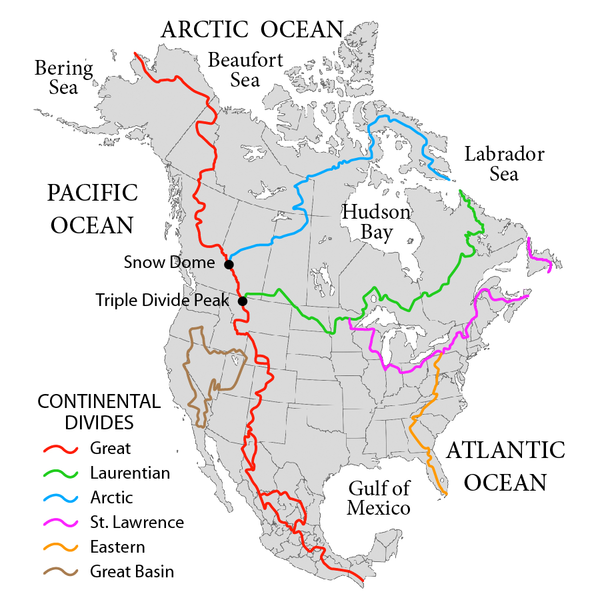
Talk about unique geographic points, most of us know of the Continental Divide Line. But I did not know about a Triple Divide Peak until I visited Glacier NP in Montana. Of course I did not climb up to that peak, but only took pictures. Water falling on that peak may flow to the Atlantic, the Pacific, or the Arctic Oceans.

How did surveyors find this out? Interesting!

Very cool! - I have to start combining travel with more geographic exploration.

How did the surveyors find this out? - probably from early USGS maps

The National Map: 125 Years of Topographic Mapping
 
Talk about unique geographic points, most of us know of the Continental Divide Line. But I did not know about a Triple Divide Peak until I visited Glacier NP in Montana. Of course I did not climb up to that peak, but only took pictures. Water falling on that peak may flow to the Atlantic, the Pacific, or the Arctic Oceans.

On someone's bucket list somewhere is to climb the Triple Divide Peak, improvise a wilderness latrine right there at the summit, and allow their morning coffee to flow out naturally and eventually run into three different oceans. Amazing!
 
On someone's bucket list somewhere is to climb the Triple Divide Peak, improvise a wilderness latrine right there at the summit, and allow their morning coffee to flow out naturally and eventually run into three different oceans. Amazing!

We are [-]urine[/-] stardust, we are golden..."
 
The northeastern slope of the Triple Divide Peak in Glacier NP, USA, drains into the Hudson Bay, and some consider that to be part of the Atlantic instead of the Arctic Ocean. The southeastern slope drains into the Missouri River, which then joins the Mississippi River to flow south. The western side flows into the Columbia River. So, the 3 paths are quite distinct and almost 120 degrees apart. It looks like a Triple Divide to me.

The other similar point is Snow Dome in Jasper NP, Canada. I visited it on the same trip earlier this summer, when we stopped by Glacier NP. The Snow Dome drains into the Arctic Ocean in the north, the Hudson Bay in the east, and to the Pacific Ocean via the Columbia River in the west. These 3 paths are also 120-deg apart, and certainly make the Snow Dome a Triple Divide too.

I have linked in a map from Wikipedia. Note that the colored lines are the Divide Lines, and not the rivers that flow from these points.

600px-NorthAmerica-WaterDivides.png
 
Last edited:
I'm going to Sackets Harbor, NY tomorrow to visit a good friend.
I may stay until Wed, while Mr B studies Sun-Mon and goes to classes Tues-Wed. This may be my last trip up north for the year :(

Panoramio - Photo of Sackets Harbor, NY

Sackets Harbor, New York - Wikipedia, the free encyclopedia

Sackets Harbor has a microbrewery, a small marina, a brick oven pizzeria, several boutique type artsy shops, and a brick church with real stained glass windows. I may go visit the historic cemetery and the Old Barracks complex.

Oh, almost forgot...and pick the last crop of tomatoes and peppers in the greenhouse. I do free weeding and get free veggies in return. :)
 
The northeastern slope of the Triple Divide Peak in Glacier NP, USA, drains into the Hudson Bay, and some consider that to be part of the Atlantic instead of the Arctic Ocean. The southeastern slope drains into the Missouri River, which then joins the Mississippi River to flow south. The western side flows into the Columbia River. So, the 3 paths are quite distinct and almost 120 degrees apart. It looks like a Triple Divide to me.

The other similar point is Snow Dome in Jasper NP, Canada. I visited it on the same trip earlier this summer, when we stopped by Glacier NP. The Snow Dome drains into the Arctic Ocean in the north, the Hudson Bay in the east, and to the Pacific Ocean via the Columbia River in the west. These 3 paths are also 120-deg apart, and certainly make the Snow Dome a Triple Divide too.

I have linked in a map from Wikipedia. Note that the colored lines are the Divide Lines, and not the rivers that flow from these points.

600px-NorthAmerica-WaterDivides.png

Interesting. The purple "continental divide" drawn through Chicago may actually cross the southern tip of Lake Michigan since the south part of the lake flows south to the Gulf of Mexico, and the north part through the St. Lawrence seaway.
 
Last edited:
Interesting. The purple "continental divide" drawn through Chicago may actually cross the southern tip of Lake Michigan since the south part of the lake flows south to the Gulf of Mexico, and the north part through the St. Lawrence seaway.

The map likley reflects the natural situation where the divide was about 5 miles inland up the chicago river when it flowed into the lake.
 
Seeing that Nords just announced another trip to the mainland, I wondered what the airfare cost was like (our last trip to Kauai was a few years ago). Out of curiosity, I checked on the Web. Then, out of curiosity again, I looked to see what timeshare was available in Hawaii for us to exchange ours.

The end result is that I just booked a week for us in the end of November on the spur of the moment. Too much driving on the RV this year, and I want a fly-and-drive trip this time. We will spend time in Kona, which we have not been to.

Surfing the forum is an expensive past-time!
 
Last edited:
DW and I are taking the Oceania Riveria cruise Dec 10-20. Called the Mayan Mistique. Stops are Grand Cayman Island, two in Mexico, Belize, Guatamala, Honduras and Key West. S/B fun... unless the world REALLY does end 12/20!
 
Out of curiosity, I checked on the Web. Then, out of curiosity again, I looked to see what timeshare was available in Hawaii for us to exchange ours.

You are probably aware of this website but BEAT OF HAWAII - Hawaii Travel Deals, Tips, Culture and Analysis is a good resource for Hawaii travel... well, all things Hawaii.

In any event, I envy your trip. It has been about five years since we've been there and the "tug" is turning into a full-scale "pull" to return.
 
The map likley reflects the natural situation where the divide was about 5 miles inland up the chicago river when it flowed into the lake.
The map likely illustrates the natural boundaries rather than the man-made Chicago "water steal" where they take fresh water from Michigan and dump treated sewage and rain water into the Mississippi collection area.
 
In any event, I envy your trip. It has been about five years since we've been there and the "tug" is turning into a full-scale "pull" to return.
You do not have to envy me. Just go to the Web to look for a flight and click "buy". :)

An impetus for me to do this was that when I told my wife about the airfare (which looked so cheap after all that money we poured into the RV tank), my wife said that we still had some unused credits on our timeshare that would expire in Jan 2013. Use it or lose it. So, I decided to spend a bit of money to use the credits to go somewhere we have not been. We have been to Oahu, Maui, Kauai, and the big island too, but we flew to Hilo and did not have time to spend in the Kona area.

Quite a few of our trips have been spurs of the moment like this. That makes life more exciting.
 
Last edited:
Leaving for Grand Cayman in the morning. I'm hoping to get some dives in although I haven't been diving in about 10 years. I put a new battery in my dive computer and it is working fine. The camera that worked with my housing died several years back but I found a plastic camera bag rated to 200 feet. I will try that with my old cell phone as a camera.
 
Seeing that Nords just announced another trip to the mainland, I wondered what the airfare cost was like (our last trip to Kauai was a few years ago). Out of curiosity, I checked on the Web. Then, out of curiosity again, I looked to see what timeshare was available in Hawaii for us to exchange ours.
Surfing the forum is an expensive past-time!
We regularly spend $650-$750 for round-trip airfare between Houston & Honolulu. It's an eight-hour redeye, which means you get a close approximation of real sleep in between all the cabin service and yakking over the PA system. It's much more expensive than flying through LAX or SFO, but I'm done with that torture. It's a lot easier (on your body) to fly the longest non-stop you can before making a connection-- or renting a car.

Of course that airfare isn't the real price, because if you want actual legroom then it's another $150-$200 round trip.

However that's still a bargain compared to our daughter flying home from mid-Dec to early Jan. That flight set her back over $1400. All part of the college fund.

In your case, surfing the forum is a lot cheaper than surfing the waves!
 
they had some deals a while back to hawaii. $350ish r/t sticks in my mind from just about any major hub in the US. DW and I snagged $350ish r/t first class tickets from LAS-OGG for next memorial day on Alaska back in August. Surfing flyertalk's threads is the real expensive "hobby." It also developed a trip to Israel when they had their $350ish r/t JFK-TLV fire sale.
 
http://beatofhawaii.com/hawaii-deals-91-each-way-this-winter/

If you thought we’d seen the end of the approx. $100 each way Hawaii deals, apparently we have not. When we last reported on these, validity was only for early December 2012. Now there are dates for the typically expensive snow bird season, in January and early February. Some of these extend to early June for just a little more.

Availability for these unadvertised Hawaii deals varies greatly by city and dates and will likely disappear quickly.
 
However that's still a bargain compared to our daughter flying home from mid-Dec to early Jan. That flight set her back over $1400. All part of the college fund.

Don't forget that contracted ROTC cadets/midshipmen are eligible to fly Space-A. A flight from Houston to Sacramento and a couple days of lodging at Travis AFB should be much cheaper than $1400 when she comes home this summer.
 
Status
Not open for further replies.
Back
Top Bottom