 |
|
 08-28-2019, 04:27 PM
|
#41
|
|
Moderator Emeritus
Join Date: Aug 2007
Location: Northern Illinois
Posts: 16,603
|
 Quote: Quote:
Originally Posted by TromboneAl

That way, if I assume that point 18 is approximately due east of CP101,..
|
Dont. You could be way off.
|

|

|
 |
Join the #1 Early Retirement and Financial Independence Forum Today - It's Totally Free!
Are you planning to be financially independent as early as possible so you can live life on your own terms? Discuss successful investing strategies, asset allocation models, tax strategies and other related topics in our online forum community. Our members range from young folks just starting their journey to financial independence, military retirees and even multimillionaires. No matter where you fit in you'll find that Early-Retirement.org is a great community to join. Best of all it's totally FREE!
You are currently viewing our boards as a guest so you have limited access to our community. Please take the time to register and you will gain a lot of great new features including; the ability to participate in discussions, network with our members, see fewer ads, upload photographs, create a retirement blog, send private messages and so much, much more!
|
|
08-28-2019, 04:29 PM
|
#42
|
|
Moderator Emeritus
Join Date: Aug 2007
Location: Northern Illinois
Posts: 16,603
|
Quote:
Originally Posted by NW-Bound
Without a physical marker, we are only guessing.
I have not seen or found a marker on my city lot, but up in my high-country home, they are rebars that were driven into the ground, and ground erosion caused them to stick out 1/2" off the ground, and very easy to locate.
All the points of the polygon defining my lot as shown on the county plat map are marked by these rebars, and I found them all.
PS. In this case, T-Al found a physical marker at CP #101, but I wonder if there is anything official to tie this marker to any other points on the map. Is it really point #18?
|
At least 2 physical monuments and their coordinates are needed to accurately determine where the coordinate points in the list are located on the ground
|
|
|
|
|
08-28-2019, 04:54 PM
|
#43
|
|
Thinks s/he gets paid by the post
Join Date: Dec 2014
Location: St. Charles
Posts: 3,919
|
I think Ronstar is on the mark. Without the actual coordinates of CP#101, everything else is a guess.
To OP: why don't you have the coordinates and details? If you paid for the survey, that should be automatic.
If you did not pay for it, well, it's worth what you paid for it.
As I recall from surveying (in college 40 years ago), the CP is a control point, and was established by working from a nearby monument with known coordinates.
As said earlier, it's location was probably picked so the transit could see the points required for the survey. It's actual location is meaningless, except to know the coordinates.
__________________
If your not living on the edge, you're taking up too much space.
Never slow down, never grow old!
|

|
|
|
08-28-2019, 05:24 PM
|
#44
|
|
Give me a museum and I'll fill it. (Picasso)
Give me a forum ...
Join Date: Jun 2006
Posts: 12,880
|
Quote:
Originally Posted by CRLLS
Al, you are assuming that CP101 is virtually at the same Northerly location as #18, which has yet to be proven one way or another. It appears to be hand drawn on this document. Can you find ANY of the lot markers? In my area they are generally iron pipe driven into the ground at or below ground level. A metal detector will help find them if you know the approximate area to look. I would be surprised if the roadway is that far onto the Northern most home.
|
Yeah, good points. I do think that the as-built entrance to the road is significantly farther south than it's supposed to be, though perhaps not to the extent shown in my diagram. I seem to remember seeing a marker just behind the mailboxes. Any markers would now be buried under the gravel of the driveway and the plants on the northern neighbor's yard. I found a marker closer to my house, and it is just a large nail with a washer around it.
Back before the neighbors from hell moved in, none of this was an issue.
Mr. Artist did move the rocks back an amount as shown by the weed barrier that is now exposed. I think we will just call this a win, and move on.
__________________
Al
|
|
|
|
|
08-28-2019, 06:34 PM
|
#45
|
|
Give me a museum and I'll fill it. (Picasso)
Give me a forum ...
Join Date: Jul 2008
Posts: 35,712
|
Quote:
Originally Posted by TromboneAl
Yeah, good points. I do think that the as-built entrance to the road is significantly farther south than it's supposed to be, though perhaps not to the extent shown in my diagram. I seem to remember seeing a marker just behind the mailboxes. Any markers would now be buried under the gravel of the driveway and the plants on the northern neighbor's yard. I found a marker closer to my house, and it is just a large nail with a washer around it.
Back before the neighbors from hell moved in, none of this was an issue.
Mr. Artist did move the rocks back an amount as shown by the weed barrier that is now exposed. I think we will just call this a win, and move on.
|
But the neighbor from hell might simply be claiming what he paid for.
Meanwhile, the bush planted by the northern neighbor just keeps expanding and encroaching.
Aye, aye, aye...
__________________
"Old age is the most unexpected of all things that happen to a man" -- Leon Trotsky (1879-1940)
"Those Who Can Make You Believe Absurdities Can Make You Commit Atrocities" - Voltaire (1694-1778)
|
|
|
|
|
08-28-2019, 06:44 PM
|
#46
|
|
Thinks s/he gets paid by the post
Join Date: Apr 2016
Location: Dutchess County
Posts: 1,599
|
Lets see, if I were rock wall guy now I would go after northern neighbor for encroaching on road and put the blame on you and for sure I would go after your shed setback. Oh you thought I was a bad neighbor before? Lol, you ain't seen nothing yet.
|
|
|
|
|
08-28-2019, 06:52 PM
|
#47
|
|
Give me a museum and I'll fill it. (Picasso)
Give me a forum ...
Join Date: Jul 2008
Posts: 35,712
|
Looking again at the photo, I wonder if the original road was between the row of mailboxes and the water meter of the "neighbor from hell". In other words, points 14 and 17 are behind the mailbox post and the water meter.
If the above is correct, then the southern guy now has his property correctly demarcated. The northern friendly neighbor, on the other hand, has made clever use of the shrub to expand his territory.
__________________
"Old age is the most unexpected of all things that happen to a man" -- Leon Trotsky (1879-1940)
"Those Who Can Make You Believe Absurdities Can Make You Commit Atrocities" - Voltaire (1694-1778)
|
|
|
|
|
08-28-2019, 06:55 PM
|
#48
|
|
Give me a museum and I'll fill it. (Picasso)
Give me a forum ...
Join Date: Jul 2008
Posts: 35,712
|
Quote:
Originally Posted by Ronstar
At least 2 physical monuments and their coordinates are needed to accurately determine where the coordinate points in the list are located on the ground
|
Yes. We need two points to determine the orientation of the map.
In this case, because the public road in front gives us a rough direction of the western edge of the lots, one physical marker shall suffice to tell within a foot or two where things should lie.
__________________
"Old age is the most unexpected of all things that happen to a man" -- Leon Trotsky (1879-1940)
"Those Who Can Make You Believe Absurdities Can Make You Commit Atrocities" - Voltaire (1694-1778)
|
|
|
|
|
08-28-2019, 07:54 PM
|
#49
|
|
Give me a museum and I'll fill it. (Picasso)
Give me a forum ...
Join Date: Jun 2006
Posts: 12,880
|
Now for a general question: If all points on a map included their GPS location, most of this surveyor stuff would be unnecessary. You go out with your phone or geocaching toy, and each point is easily found.
Why isn't it like that?
__________________
Al
|
|
|
|
|
08-28-2019, 08:10 PM
|
#50
|
|
Give me a museum and I'll fill it. (Picasso)
Give me a forum ...
Join Date: Jul 2008
Posts: 35,712
|
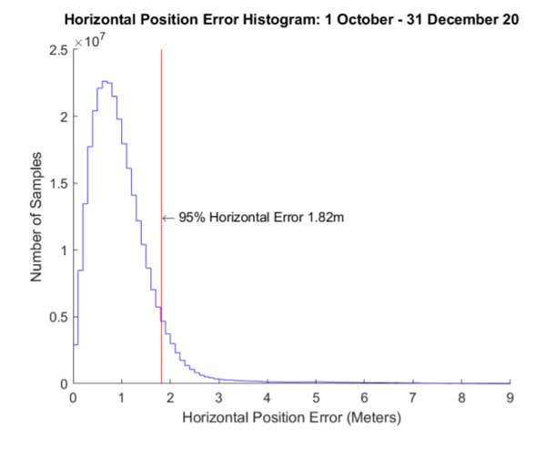
Maps were done long before the advent of GPS. And even now, GPS is only good to a few feet, unless you have special equipment to do differential GPS technique to get down to a few inches.
See below chart of the accuracy of a high-quality GPS as measured by the FAA. And I link this chart as it is published on the official GPS.gov site.
And this site says "For example, GPS-enabled smartphones are typically accurate to within a 4.9 m (16 ft.) radius under open sky".
GPS is wonderful for its ability to determine absolute positioning in real time. But to measure relative position of two points, a tape measure and a theodolite are still more precise.
For details, see: https://www.gps.gov/systems/gps/performance/accuracy/.
__________________
"Old age is the most unexpected of all things that happen to a man" -- Leon Trotsky (1879-1940)
"Those Who Can Make You Believe Absurdities Can Make You Commit Atrocities" - Voltaire (1694-1778)
|
|
|
|
Can You Interpret These Land Survey Numbers?
|
08-28-2019, 08:23 PM
|
#51
|
|
Moderator Emeritus
Join Date: Aug 2007
Location: Northern Illinois
Posts: 16,603
|
Can You Interpret These Land Survey Numbers?
Its a good thought. And the survey drawings that we used to produce for state highways included a list of state plane coordinates that are easily translated to latitude and longitude. We could easily find or reset a monument if need be using published coordinates and survey grade gps with accuracy of about a quarter of an inch
Keep in mind that cell phone and handheld gps devices have accuracies of around 10-15. Maybe accurate enough to help locate a monument if you had a good metal detector. But not accurate enough to determine if the monument found is exactly at the published coordinates. But future gps satellites and receivers should make what you mention quite feasible.
|
|
|
|
|
08-29-2019, 09:58 AM
|
#52
|
|
Confused about dryer sheets
Join Date: Aug 2017
Location: Shenandoah Valley
Posts: 8
|
 EPSON007.jpg
Here is a sketch showing the OP original information in a format more user friendly for the layperson. Solid lines are known information from the post, dashed lines are assumed by me. I am pretty certain the information was generated by a surveyor inputting the plat of record for the original subdivision of land.
The location of CP101 can not be determined by the information provided.
Ledbet
|
|
|
|
|
08-30-2019, 08:48 AM
|
#53
|
|
Give me a museum and I'll fill it. (Picasso)
Give me a forum ...
Join Date: Jun 2006
Posts: 12,880
|
Thanks, LedBet.
Do you think that GPS devices accurate to a few inches will become available to consumers at some point?
__________________
Al
|
|
|
|
|
08-30-2019, 01:30 PM
|
#54
|
|
Confused about dryer sheets
Join Date: Aug 2017
Location: Shenandoah Valley
Posts: 8
|
They are widely available now, but not at a price laypeople would be willing to readily pay. For surveyors a 2 unit GPS system that does differential solutions in real time is $15-30K. A single GPS unit that requires a subscription to a reference network for real time solutions is less, but requires a cellular data connection and the reference net work fee. We use both on a regular basis at my former business and they have changed surveying in many ways, but are not the solution to everything. They still have limits due to ground cover such as trees/vegetation, and interference from building and such in urban settings.
|
|
|
|
|
09-03-2019, 07:04 PM
|
#55
|
|
Full time employment: Posting here.
Join Date: Aug 2017
Location: claremont
Posts: 601
|
There might be some notes in the data file that provide the location and orientation reference frame for the local coordinate system. Measuring numbered points from a common reference with a semi automated surveying rig would definitely generate such a datafile structure.
|
|
|
|
|
|
|
Currently Active Users Viewing This Thread: 1 (0 members and 1 guests)
|
|
|
 Posting Rules
|
You may not post new threads
You may not post replies
You may not post attachments
You may not edit your posts
HTML code is Off
|
|
|
|

 » Recent Threads
|
|
|
|
|
|
|
|
|
|
|
|
|
|
|
|
|
|
|
|
|
|
|
|
|
» Quick Links
|
|
|


 Linear Mode
