East Texas
Full time employment: Posting here.
- Joined
- Dec 29, 2010
- Messages
- 746
A farmhouse is protected by a small levee while another stands flooded near Yazoo City, Miss., Thursday, May 19, 2011. For thousands of people forced from their homes by the rising Mississippi River, life has become a tedious waiting game: waiting for meals at shelters, waiting for the latest word on their flooded homes, waiting for the river to fall. (AP Photo/Dave Martin)
") . A bigger photo of the surrounding area of Yazoo City, MS--the house in the above photo is in the lower left corner here. I imagine the folks involved don't have a lot of time to be writing about how they created these levees. The farmland is going to be very enriched from the flooding, I believe.
. A bigger photo of the surrounding area of Yazoo City, MS--the house in the above photo is in the lower left corner here. I imagine the folks involved don't have a lot of time to be writing about how they created these levees. The farmland is going to be very enriched from the flooding, I believe.

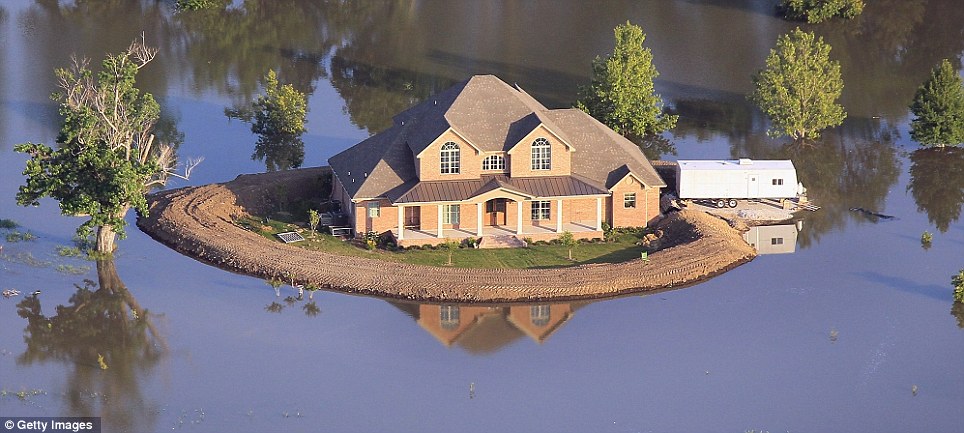

I've been scanning the internet for a couple of days and am unable to find the story behind this particular homemade levy. Do any of you know who/where/how, etc? I find this particular levee fascinating.
Here is the souce: Huffington Post
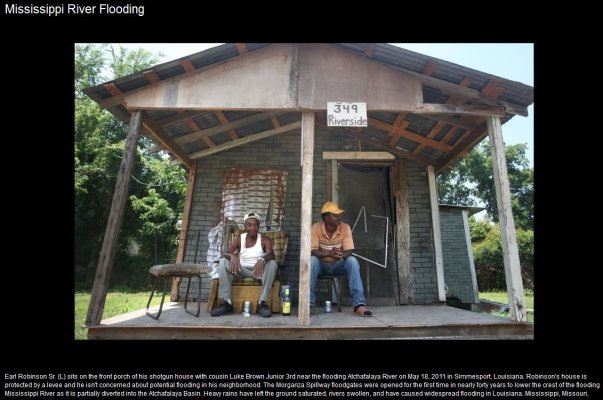
Here is 349 Riverside!
Born in that town and lived there my first 18 years. But I don't think I know Earl and Luke.
Checked it out on Google maps. This address is within the "ring levee", which, as the name implies, surrounds the town. The only real danger to them is from the north -- Bayou De Glaise which floods from the river, and from the east, the Atchafalaya river. The levees are massive. I do remember them leaking some in 1973. And no, you simply cannot compare rivers like the Atchafalaya and Mississippi to, say, the Trinity river in the DFW area -- that would be laughable.
About the time I was finishing high school, a family friend who typically had three sheets to the wind told me to never forget where I came from. Well, folks, it ain't much, but that's where I'm from, and I haven't forgotten.
Handyman's delight, fixer-upper, needs TLC, lots of potential, good bones........ I'm sure there are more.
Pay attention to key words when you're looking for a place to live / work: basin, flood plain, green belt, below sea level.... I'm sure there are more.