Aaarrgghh. Worked on a version of this last night and this afternoon, and the system/site ate it. Luckily for you, that resulted in a shorter post!
After the big cruise, we disembarked in Ushuaia, ARG. We had determined that it was considerably easier and more economical to rent and return a vehicle in Chile than in Argentina. Thus, we took a fairly relaxing 10 hour bus ride over to Punta Arenas, crossing by ferry over the Straits of Magellan on the way.
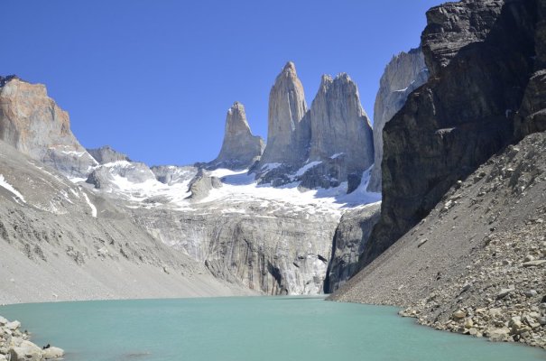
From Punta Arenas, we took an easy drive up the paved highway to Puerto Natales, the gateway to Torres Del Paine. Soon before the Park, we lost pavement, and the sprawling Park itself contained well-maintained gravel roads. If you do this park, choose your hotel (or campsite) wisely. We did a variety of things and would have been better off moving between lodgings—as it was, we had a 90-minute drive to and from one of our hikes. The hiking here lived up to all its hype, and as shown on an attached picture, we got lucky with a spectacularly clear day for DW’s most anticipated hike of the trip (the Mirador Torres Del Paine, aka, the hike to the base of the towers). (The other long hike did give us three hours without rain—but those hours were surrounded by 5 hours of wind and rain!).
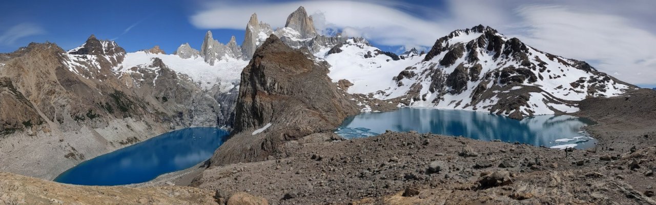
After TDP, we drove across the border to El Calafate (Perito Moreno Glacier has excellent viewing access from boardwalks), and on to the other hiking mecca, El Chalten. If you are a hiker, do not miss the opportunity to hike the Sendero al Fitzroy. The summit is tough (400M in the last kilometer, after you’ve already gone 10K), but the view of Mt. Fitzroy over the twin lagoons is well worth it. (Panoramic pic attached).
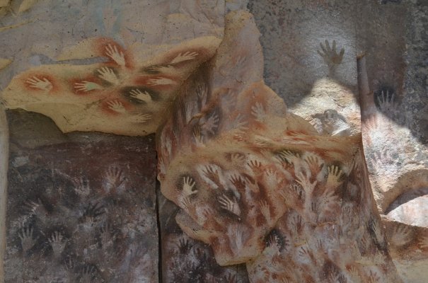
After El Chalten, we drove east through the desert steppes for a while to visit the UNESCO heritage site of Cueva de los Manos, where you see reverse image handprints (and other art) that are up to 13,000 years old. (pic attached).
By this point, we were off to a good start, with great scenery, glaciers, cloud formations, and a wide variety of wild life. The latter included a few condors (2 of them close enough for good pics), a native fox, guanacos and lesser rheas out the wazoo, Pink Flamingoes, endemic geese, black necked swans, a male Magellanic Woodpecker, and a host of other birds.
Next up: the long drive to Chile, the goodbye to paved roads, and hello to the Carretera Austral. This “highway” runs for 1250 kilometers through the mostly unpopulated southern Patagonia of Chile. The road was only built beginning in 1978 because of General Pinochet’s fear of an Argentine war—and until that time, the only access to most of the south was via Argentine highways or ship. Today, construction continues, as it is hoped to have the road completely paved at some point (I think it is at about 250 kilometers of pavement right now). This road made us quite happy to have a real 4WD pickup truck with a manual transmission. Even without the side roads that mandated 4WD, we would have had a hard time with a 2wd vehicle.
We drove about 1000 of the present 1250 kilometers of this road (an extension is underway to add another 750 KM). Suffice it to say that it was not a walk in the park, although we took many excellent hikes in the National Parks that surround the highway for most of its distance. If you do it, remember to fill up with gas/diesel at every opportunity, and it is a good idea to have snacks and plenty of water in your passenger compartment!
Nonetheless, we’d highly recommend the journey if you are adventuresome. Most of the time, you’ll have the road to yourself—even to the point of being able to stop in the middle of long one-lane bridges to allow your photographer to exit the vehicle! And the scenery is just a whole level up; we actually got a little bit inured to waterfalls, glaciers, and fjords. While I don’t know if it truly qualifies as “the most scenic highway in the world,” it has to be among the few in the running.
One last point about the Carretera: with the financial and planning assistance of the founders and executives of North Face and Patagonia clothing lines, Chile is planning to make the highway an even more attractive destination for adventure travelers. It is the core of the planned “Ruta de los Parques,” which will be 1700 miles long, connect 17 national parks encompassing 28,000,000 acres, and constitute about 1/3 of the entire country.
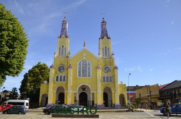
After the Carretera, we crossed to the fascinating Chiloe Island. This area has an interesting history, in that it was deemed inconsequential by the Spanish and the early Chilean governments, which left its European and indigenous inhabitants free of outside influence and able to create a mixed culture unique to South America. Now, however, it is much more populated than anywhere along the Carretera, and you likely must search pretty deeply to discover any remaining pockets of that culture. The architecture is fascinating though, with many German influences (unbeknownst to me, both Chile and Argentina aggressively courted German emigrants in the late 19th and early 20th centuries). For example, German Jesuits build hundreds of churches on the main island and its archipelago during their evangelization efforts in the 18th and 19th centuries. (Picture of one church attached)
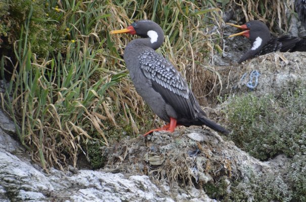
The island is also a great place to see Penguins, several species of cormorants, and a wealth of other birds. (Picture of red leg Cormorant attached) Finally, its Curanto dish is an interesting take on seafood stew, and recent genetic analyses show that Chiloe was the cultivating melting pot in which more than 90% of the potatoes presently grown throughout the world originated. (Its plants, unlike those directly from the Andes, were resistant to the great potato blight.)
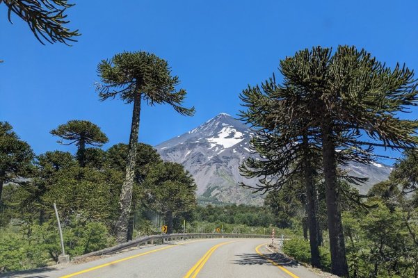
After Chiloe, we continued north, but the environment had changed. Now we not only had paved roads, but toll roads built to US interstate standards, along with frequent gas stations, real supermarkets, fancy restaurants, and a plethora of lodgings to choose from! Nonetheless, the map indicated that we were still relatively deep in Patagonia. This begins the part of our trip that would be perfect for those who want the comforts of civilization while still enjoying fantastic scenery and good hiking opportunities. The following cities are located in this area and would be worthwhile bases: Chile: Puerto Varas (founded by Germans in 1850s) and Pucon; Argentina: Bariloche, Villa la Angustura, and San Martin de los Andes. We did a number of hikes in this area, and the driving was easy and beautiful on both sides of the border. (Picture of a nice highway with great scenery is attached)
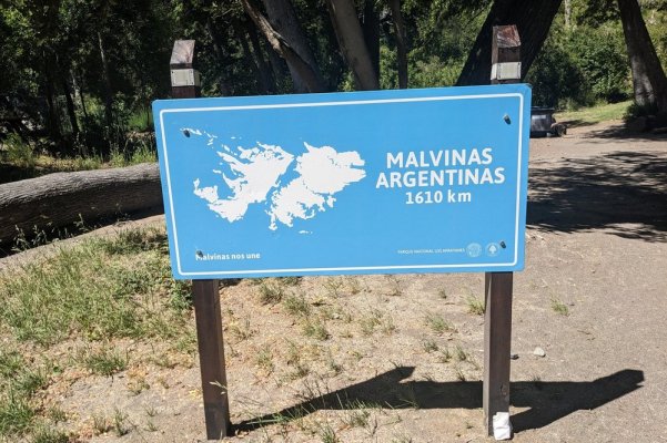
Oh, I almost forgot to include this promised picture. When you visit Argentine parks, you are frequently reminded that the Argentine government has not forgotten about the 1982 Falklands War. I believe we saw signs like the attached one, referring to the Malvinas/Falklands, in almost every Argentine Park
Apologies for the length of this post, but I barely scratched the surface of what we saw. If you are interested in seeing a lot more pictures, or to help in planning for a trip, here is a link to the first of 23 posts on the driving trip in DW’s ad-free blog: https://www.lisajtravels.com/2022/12/3/starting-into-southern-patagonia (Note, the blog is for when we get old, but also for sharing. If you try this link after a couple of months, it won’t work—the post will be in the archive section of the blog once we get going on another trip that we want to memorialize.)
After the big cruise, we disembarked in Ushuaia, ARG. We had determined that it was considerably easier and more economical to rent and return a vehicle in Chile than in Argentina. Thus, we took a fairly relaxing 10 hour bus ride over to Punta Arenas, crossing by ferry over the Straits of Magellan on the way.
From Punta Arenas, we took an easy drive up the paved highway to Puerto Natales, the gateway to Torres Del Paine. Soon before the Park, we lost pavement, and the sprawling Park itself contained well-maintained gravel roads. If you do this park, choose your hotel (or campsite) wisely. We did a variety of things and would have been better off moving between lodgings—as it was, we had a 90-minute drive to and from one of our hikes. The hiking here lived up to all its hype, and as shown on an attached picture, we got lucky with a spectacularly clear day for DW’s most anticipated hike of the trip (the Mirador Torres Del Paine, aka, the hike to the base of the towers). (The other long hike did give us three hours without rain—but those hours were surrounded by 5 hours of wind and rain!).
After TDP, we drove across the border to El Calafate (Perito Moreno Glacier has excellent viewing access from boardwalks), and on to the other hiking mecca, El Chalten. If you are a hiker, do not miss the opportunity to hike the Sendero al Fitzroy. The summit is tough (400M in the last kilometer, after you’ve already gone 10K), but the view of Mt. Fitzroy over the twin lagoons is well worth it. (Panoramic pic attached).
After El Chalten, we drove east through the desert steppes for a while to visit the UNESCO heritage site of Cueva de los Manos, where you see reverse image handprints (and other art) that are up to 13,000 years old. (pic attached).
By this point, we were off to a good start, with great scenery, glaciers, cloud formations, and a wide variety of wild life. The latter included a few condors (2 of them close enough for good pics), a native fox, guanacos and lesser rheas out the wazoo, Pink Flamingoes, endemic geese, black necked swans, a male Magellanic Woodpecker, and a host of other birds.
Next up: the long drive to Chile, the goodbye to paved roads, and hello to the Carretera Austral. This “highway” runs for 1250 kilometers through the mostly unpopulated southern Patagonia of Chile. The road was only built beginning in 1978 because of General Pinochet’s fear of an Argentine war—and until that time, the only access to most of the south was via Argentine highways or ship. Today, construction continues, as it is hoped to have the road completely paved at some point (I think it is at about 250 kilometers of pavement right now). This road made us quite happy to have a real 4WD pickup truck with a manual transmission. Even without the side roads that mandated 4WD, we would have had a hard time with a 2wd vehicle.
We drove about 1000 of the present 1250 kilometers of this road (an extension is underway to add another 750 KM). Suffice it to say that it was not a walk in the park, although we took many excellent hikes in the National Parks that surround the highway for most of its distance. If you do it, remember to fill up with gas/diesel at every opportunity, and it is a good idea to have snacks and plenty of water in your passenger compartment!
Nonetheless, we’d highly recommend the journey if you are adventuresome. Most of the time, you’ll have the road to yourself—even to the point of being able to stop in the middle of long one-lane bridges to allow your photographer to exit the vehicle! And the scenery is just a whole level up; we actually got a little bit inured to waterfalls, glaciers, and fjords. While I don’t know if it truly qualifies as “the most scenic highway in the world,” it has to be among the few in the running.
One last point about the Carretera: with the financial and planning assistance of the founders and executives of North Face and Patagonia clothing lines, Chile is planning to make the highway an even more attractive destination for adventure travelers. It is the core of the planned “Ruta de los Parques,” which will be 1700 miles long, connect 17 national parks encompassing 28,000,000 acres, and constitute about 1/3 of the entire country.
After the Carretera, we crossed to the fascinating Chiloe Island. This area has an interesting history, in that it was deemed inconsequential by the Spanish and the early Chilean governments, which left its European and indigenous inhabitants free of outside influence and able to create a mixed culture unique to South America. Now, however, it is much more populated than anywhere along the Carretera, and you likely must search pretty deeply to discover any remaining pockets of that culture. The architecture is fascinating though, with many German influences (unbeknownst to me, both Chile and Argentina aggressively courted German emigrants in the late 19th and early 20th centuries). For example, German Jesuits build hundreds of churches on the main island and its archipelago during their evangelization efforts in the 18th and 19th centuries. (Picture of one church attached)
The island is also a great place to see Penguins, several species of cormorants, and a wealth of other birds. (Picture of red leg Cormorant attached) Finally, its Curanto dish is an interesting take on seafood stew, and recent genetic analyses show that Chiloe was the cultivating melting pot in which more than 90% of the potatoes presently grown throughout the world originated. (Its plants, unlike those directly from the Andes, were resistant to the great potato blight.)
After Chiloe, we continued north, but the environment had changed. Now we not only had paved roads, but toll roads built to US interstate standards, along with frequent gas stations, real supermarkets, fancy restaurants, and a plethora of lodgings to choose from! Nonetheless, the map indicated that we were still relatively deep in Patagonia. This begins the part of our trip that would be perfect for those who want the comforts of civilization while still enjoying fantastic scenery and good hiking opportunities. The following cities are located in this area and would be worthwhile bases: Chile: Puerto Varas (founded by Germans in 1850s) and Pucon; Argentina: Bariloche, Villa la Angustura, and San Martin de los Andes. We did a number of hikes in this area, and the driving was easy and beautiful on both sides of the border. (Picture of a nice highway with great scenery is attached)
Oh, I almost forgot to include this promised picture. When you visit Argentine parks, you are frequently reminded that the Argentine government has not forgotten about the 1982 Falklands War. I believe we saw signs like the attached one, referring to the Malvinas/Falklands, in almost every Argentine Park
Apologies for the length of this post, but I barely scratched the surface of what we saw. If you are interested in seeing a lot more pictures, or to help in planning for a trip, here is a link to the first of 23 posts on the driving trip in DW’s ad-free blog: https://www.lisajtravels.com/2022/12/3/starting-into-southern-patagonia (Note, the blog is for when we get old, but also for sharing. If you try this link after a couple of months, it won’t work—the post will be in the archive section of the blog once we get going on another trip that we want to memorialize.)
")