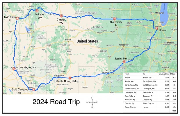
Wow! How long do you plan to spend in each location? That's a LONG road trip!
The whole trip will be 2-3 weeks long. Not much going on in the eastern 2/3 of the geographic area, so about 80% of our time will be spent in the west 1/3 of the area.
We're spending 6 days in Gold Canyon, 2-3 in Las Vegas, maybe 2 in Jackson, the rest 1 day each.
DW and I really enjoy eating at "Elevation 486" when in Twin Falls, so it's a place you might consider. Oddly enough, reservation can be required even for lunch.
Thanks - we'll roll into Twin Falls at dinner time - we'll check it out.
Is that Google Maps? I need to do one.
I used a number of software apps. Started with Google My Maps. Like Google Map, but it starts off by drawing the best route. But My Maps allows the user to drag points along the google determined route to create a user defined alternate route.
After I finalize the route in My Maps, I have the app generate directions. I get the individual trip leg driving times and mileage from the directions readout. I make an Apple Numbers spreadsheet table of travel times and mileage of each driving segment.
Also in My Maps, I do a printscreen of the map screen. I import the print screen image into Ortelius, which unfortunately is out of business. And I'm not sure if the program can be downloaded from anywhere.
But really at this point, all that is left is dressing the map up by adding text and symbols to the printscreened map, and copy/ paste the spreadsheet in. This can be done in photoshop without ortelius.
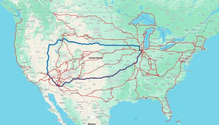
In reality, you can do all the heavy lifting in MyMaps and end up with good map, with turn by turn directions of any route you want to take. I think there is a limit as to how many waypoints can be added.