You are using an out of date browser. It may not display this or other websites correctly.
You should upgrade or use an alternative browser.
You should upgrade or use an alternative browser.
Hurricanes
- Thread starter GTM
- Start date
GTM said:Besides the obvious current problems they have created do you see past and future hurricanes as a serious problem for the economy.
I'm freaking out over Rita as it is. IMO, Katrina pushed us to the edge, and Rita will probably push us over. I have been thinking about this coming winter, and how many news stories will be on TV about people freezing to death in New England

As far as a 'major issue' in terms of future hurricanes.... two data points is not enough to establish a trend for more/stronger storms, so I don't see them as any more/less an issue than they were before. This just happens to be two large storms in a row hitting two critical areas of our energy infrastructure.
BigMoneyJim
Thinks s/he gets paid by the post
I recall reading an article suggesting that the past 50-80 years or so have been a lull in traditional hurricane activity for the Gulf and East Coasts. No idea if that's true, but I think the supply chains will adapt to the increased threat, if any.
I can't speak to short-term supply shortages and the longer-term ripple effect on the economy.
I can't speak to short-term supply shortages and the longer-term ripple effect on the economy.
T
TromboneAl
Guest
I was reading that hurricanes that get big soon, often undergo fluctuations in magnitude. Rita is a 5 now, but it could fluctuate down to a 3 as it hits the coast.
Marshac said:two data points is not enough to establish a trend for more/stronger storms
And now to refute myself-
TromboneAl said:I was reading that hurricanes that get big soon, often undergo fluctuations in magnitude. Rita is a 5 now, but it could fluctuate down to a 3 as it hits the coast.
You can see the estimated wind speeds over time at this website-
http://www.nhc.noaa.gov/refresh/graphics_at3+shtml/085837.shtml?chart

BigMoneyJim said:I recall reading an article suggesting that the past 50-80 years or so have been a lull in traditional hurricane activity for the Gulf and East Coasts. No idea if that's true, but I think the supply chains will adapt to the increased threat, if any.
I've heard similar. One popular explanation is that there is a 20-25 year cycle. I've even heard it linked to cycles in solar activity. I don't think anyone really knows yet, even if they say they do.
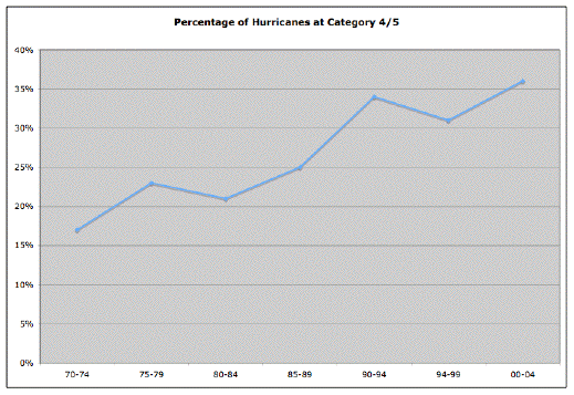
"We're now in a very active hurricane era," confirms Dr. Gerry Bell, a seasonal hurricane forecaster for the National Oceanic and Atmospheric Administration (NOAA). "Last year was very active, the year before that was very active. …This active hurricane era began in 1995. Since 1995, nine out of the last 11 hurricanes seasons have above normal."
Bell tells Russ Mitchell of The Saturday Early Show hurricane activity comes in cycles that can last several decades.
...
"The previous active hurricane era was during the 1950s and 60s. Then we were pretty inactive for about a 25 year period, from 1970 to 1994, and now we're back in an active hurricane era," Bell points out.
"If there was a Category 6, Rita would be there," said CBS News Meteorologist George Cullen. "This is an incredible storm right now, the third most intense hurricane ever recorded."
T
TromboneAl
Guest
Could be a fizzlecane, ya never know.
I've always wondered.... what would a nice big nuke right in the eye of a big hurricane do? Whenever you see those old nuclear testing films, shortly after detonation, a cloudy sky becomes clear from the shockwave/heat/whatever. I did some half-hearted googling last night, but couldn't find anything.
I wonder how much of the last 20 years' rise in storms is due to an improvement in satellite surveillance.Marshac said:As far as a 'major issue' in terms of future hurricanes.... two data points is not enough to establish a trend for more/stronger storms, so I don't see them as any more/less an issue than they were before. This just happens to be two large storms in a row hitting two critical areas of our energy infrastructure.
The Pacific & Atlantic are big places with plenty of deserted areas (no ship traffic). Today if a storm whips up it's picked up within 12 hours (or at least discussed), but 25 years ago the technology was a lot more primitive and the Hurricane Hunters were frequently sent out to FIND the storms, let alone obtain data. So maybe a generation ago we were blissfully ignorant.
Speaking of 25 years of technology development & rising population, is there anywhere along the American coastline that is NOT considered a "critical area of our energy infrastructure"? Maybe today's storms are causing more damage because we're obligingly providing more targets.
Geez, Marshac, is that a CHP? Or are you advocating the use of nuclear weapons for environmental modification? I can only imagine the dispersion pattern of the radioactive debris.Marshac said:I've always wondered.... what would a nice big nuke right in the eye of a big hurricane do? Whenever you see those old nuclear testing films, shortly after detonation, a cloudy sky becomes clear from the shockwave/heat/whatever. I did some half-hearted googling last night, but couldn't find anything.
I think we'll talk to our Navy meteorological shipmates. I'm sure the question has been discussed on a few midwatches... maybe we could find a way for the nuclear-detonation simulation supercomputers to chat with the meteorological simulation supercomputers.
cube_rat
Thinks s/he gets paid by the post
- Joined
- Jul 12, 2005
- Messages
- 1,466
I live smack dab in the California earthquake zone. I have the Calaveras fault on the east side of me and San Andreas to the left. We haven't had a biggie since '89. I was in the '89 quake which was measured at 7.x Believe me it was terrifying and LOOOONG in duration. I still remember the floor boards under my legs moving in a fluid fashion and things flying across the room as I huddled under my desk.
At least with a hurricane, folks get notification and have a chance to evacuate. Earthquakes just happen and could be equally as devastating in nature. Remember the hwy 880 freeway collapse? People were flattened like pancakes during rush hour. It was just heartbreaking. I swear those images traumatized me to this day.
Earthquake insurance is so high with a 30-40K deductible.
At least with a hurricane, folks get notification and have a chance to evacuate. Earthquakes just happen and could be equally as devastating in nature. Remember the hwy 880 freeway collapse? People were flattened like pancakes during rush hour.
It was just heartbreaking. I swear those images traumatized me to this day.Earthquake insurance is so high with a 30-40K deductible.
Marshac said:I've always wondered.... what would a nice big nuke right in the eye of a big hurricane do? Whenever you see those old nuclear testing films, shortly after detonation, a cloudy sky becomes clear from the shockwave/heat/whatever. I did some half-hearted googling last night, but couldn't find anything.
In the Chicago Tribune, Tom Skilling answered this question on Friday, September 16.
The shock wave, or pulse of high air pressure, produced by a bomb propagates outward from the detonation site, but air pressure immediately returns to normal after the shock wave has passed because atmospheric pressure reflects the weight of air above the ground. An explosion does not change that.
Static air pressure, sure. But the dynamic air pressure exerted by the winds and the flying cows?moghopper said:In the Chicago Tribune, Tom Skilling answered this question on Friday, September 16.
Nords said:I wonder how much of the last 20 years' rise in storms is due to an improvement in satellite surveillance.
The Pacific & Atlantic are big places with plenty of deserted areas (no ship traffic). Today if a storm whips up it's picked up within 12 hours (or at least discussed), but 25 years ago the technology was a lot more primitive and the Hurricane Hunters were frequently sent out to FIND the storms, let alone obtain data. So maybe a generation ago we were blissfully ignorant.
Does your DW have any opinion on this?
Nords said:Static air pressure, sure. But the dynamic air pressure exerted by the winds and the flying cows?
From the bomb, or the hurricane?

Oh, she'll have an opportunity to voice it and I have a whole list of questions, but she won't be awake for another hour or two and I should probably wait until she's had breakfast first. (She really appreciates the interaction you guys provide so that she doesn't have to do it all!)Martha said:Does your DW have any opinion on this?
I do know that technology has almost killed the Navy's meteorological community. Personally I think it's already dead but the assignment officers just don't know where to send the extra people. Modern bandwidth & Internet connectivity, supercomputer weather simulations, improved shipboard instrumentation, and the Weather Channel have largely turned Navy weather-guessers into button-pushers. My spouse jokes about the things she knows how to do with systems that no longer exist but the truth is that we don't miss any of them and it's much better not to be so alone out there with just a barometer & anemometer.
I don't know much about the history of weather satellites-- yet. Although I'm the technology & systems geek, she tends to be the usability & products geek. Every time she's showing me something and saying "Look what it can do! See how we use this!" I'm itching to turn it off so that I can take it apart and find out how it works. But we know a guy (currently sleeping on a cot at Navy meteorological HQ in Stennis Space Center) who's been looking for a good post-doc research project... just as soon as Rita winds down...
Yes! Actually the hurricane. I bet it swallows the "average" nuclear warhead like a dog gobbling down a piece of cheese. But I'll have to see what I can find out.moghopper said:From the bomb, or the hurricane?
It'd be fun to watch the services fight over who gets to deliver the product, so to speak-- B-52s or SSBNs?
Nords said:Geez, Marshac, is that a CHP? Or are you advocating the use of nuclear weapons for environmental modification? I can only imagine the dispersion pattern of the radioactive debris.
Sure, it would increase the avg radiation dose a person would receive, but would the small increase in cancer cause more deaths than the impact of a storm like Katrina or Rita? Maybe we can find the plans for the tsar bomba....
I would be interested to know if you find out anything about hurricanes and nukes.... if it wouldn't do anything, it only makes these large storms that much more awe inspiring..... and scary.
cube_rat said:Remember the hwy 880 freeway collapse? People were flattened like pancakes during rush hour.
I still get freaked out when I am forced to drive on the Alaskan way viaduct in Seattle.... the cracks in the support columns from the quake a few years back aren't very reassuring either....
Nords said:Yes! Actually the hurricane. I bet it swallows the "average" nuclear warhead like a dog gobbling down a piece of cheese. But I'll have to see what I can find out.
I think there is no question it would. Probably wouldn't even burp after.
Maybe I wasn't clear with the quote from before (it was all of the text I could find online) but essentially he (Skilling) claims a bomb would have no effect. Pressure within the storm would "immediately return to normal after the shock wave has passed because atmospheric pressure reflects the weight of air above the ground. An explosion does not change that."
Geologists describe earth’s atmosphere as an envelope of air, rotating with the continents and oceans; receiving enormous amounts of energy from the Sun’s radiation, which powers weather events. Typical energy expended in a tornado funnel is equal to about fifty kilotons of explosives; a thunderstorm exchanges about ten times this much during its lifetime; and a moderate size Atlantic hurricane can build up to more than 1,000 megatons of energy.
Still I suppose you could argue that the disruption caused might be enough.
T
TromboneAl
Guest
I've always wondered.... what would a nice big nuke right in the eye of a big hurricane do?
Don't give Bush any ideas.
grumpy
Thinks s/he gets paid by the post
- Joined
- Jul 1, 2004
- Messages
- 1,321
Nords said:I wonder how much of the last 20 years' rise in storms is due to an improvement in satellite surveillance.
The Pacific & Atlantic are big places with plenty of deserted areas (no ship traffic). Today if a storm whips up it's picked up within 12 hours (or at least discussed), but 25 years ago the technology was a lot more primitive and the Hurricane Hunters were frequently sent out to FIND the storms, let alone obtain data. So maybe a generation ago we were blissfully ignorant.
Nords,
The GOES (Geostationary Operational Environmental Satellites) have been in continuous operation for more than 25 years. My first job at NASA in 1984 was on the project developing the second generation of these satellites. The first generation of these were "spin stabilized". That meant that their cameras and other instruments were only pointed at the earth for a portion of the time it took the satellite to rotate on its axis. In geostationary orbit the satellite remains in the same position above the equator and can "see" nearly the whole hemisphere at once. NOAA maintained a constellation of at least 3 of these satellites at all times giving full coverage of the Atlantic and Pacific Oceans. While the frequency of picrtures from these early satellites was much lower than with the current generation, by no means were we blind to hurricanes over the oceans back then. Hurricane Hunter planes may have needed to "find" where the storm had moved to since the last satellite image. The current GOES satellites are "3-axis stabilized", meaning they point their instruments and cameras at the earth continuously and can send images in near real-time.
Grumpy
I remember when a satellite (GOES 8? 9?) died about 7-8 years ago. For some reason the techs weren't able to tune their seven-meter dish electronically to the signal. So they scrambled out into the parking lot and were actually using weighted strings & protractors to get the dish pointed toward the right spot in the sky. Satellite images sucked for the time it took to move another GOES into position.grumpy said:Nords,
The GOES (Geostationary Operational Environmental Satellites) have been in continuous operation for more than 25 years. My first job at NASA in 1984 was on the project developing the second generation of these satellites. The first generation of these were "spin stabilized". That meant that their cameras and other instruments were only pointed at the earth for a portion of the time it took the satellite to rotate on its axis. In geostationary orbit the satellite remains in the same position above the equator and can "see" nearly the whole hemisphere at once. NOAA maintained a constellation of at least 3 of these satellites at all times giving full coverage of the Atlantic and Pacific Oceans. While the frequency of picrtures from these early satellites was much lower than with the current generation, by no means were we blind to hurricanes over the oceans back then. Hurricane Hunter planes may have needed to "find" where the storm had moved to since the last satellite image. The current GOES satellites are "3-axis stabilized", meaning they point their instruments and cameras at the earth continuously and can send images in near real-time. Grumpy
Spouse's answers: NWS was hauled before Congress a few years back to testify about global warming. During the hearing they said that hurricane frequency appears to oscillate with a period of about 60-70 years. The last peak occurred in the 1940s, the last trough was in the 1970s, and they're expecting to see another peak in the next few years. Of course the El Nino effect on hurricanes wasn't even discovered until the 1980s and the data doesn't go back much further than the cycle, so who knows how valid this may be. NWS firmly stated that hurricane frequency is not linked to global warming, but that position is the subject of some debate. (Gee, does anyone else get the feeling that meteorology is like predicting stock market returns?)
We're still trying to figure out the nuclear weapons question. Despite the magnitudes of scale, if a butterfly's chaotic wing-flapping can supposedly lead to a hurricane then a nuclear explosion should be able to do something to it as well. Of course anything's possible with chaos theory if you can wait long enough or try enough times. I no longer hold the security clearances or the need to know whether or not the govt thinks it might actually work, which could complicate our research.
Google found about 63,000 hits for the words "nuclear meteorology hurricane" but most of them dismissed nuclear weapons out of hand like this NOAA article. The logic is that a decent hurricane is much stronger than any nuclear weapon and the effects (if any) would be complicated by the spread of radioactive debris. I also found an interesting article about Operation STORMFURY in the 1960s and another article on modern proposals.
Nords,
A bit more history on meteorological satellites - there are stationary satellites and orbiters - the old Defense Meteorological Satellite Program (DMSP) was a polar orbiter that had a visual image sensor and then as the program developed other types of energy sensors used for weather prediction. There was a recorder on the satellite which when it flew over the dedicated as well as shared ground system resources, would be downloaded and then made into film and/or ingested digitally into weather prediction computers. This was considered part of the strategic mission - the tactical mission was that while the satellite was downloading it was also filming, so tactical terminals (on Navy ships and in the field at Army/Marine or Air Force bases) could receive the 'live' data of what their local weather looked like as well.
The Air Force had a Global Weather Central in Omaha which did the strategic processing and product generation. This function was done for the Navy at Fleet Numerical Oceanography Center in Monterey.
DMSP has now become a "civilianized" program under the NPOES moniker - basically the satellites and systems are developed for both civilian and miltary uses under the same agency now. When I worked for DMSP, NOAA used a similar platform for their polar orbiter which wasn't quite as deluxe as the military version.
Holler if you want some more info on the actual launching of these puppies and/or some of the original ground system configurations.
I went and visited a weather office at and Air Force base a few years ago and was amazed at how PC technology had revolutionized the access to the type of quality data that could only be had by the strategic guys when I was working for the program (late '80s) - phenomenal - the stuff you see flying around on drudgreport is better than what we had back then. Now for info on some of the other sensors and what is being measured and what the significance is ...... interesting stuff and probably even more interesting that I know now.
Bridget
BigMoneyJim
Thinks s/he gets paid by the post
deserat said:I went and visited a weather office at and Air Force base a few years ago and was amazed at how PC technology had revolutionized the access to the type of quality data that could only be had by the strategic guys when I was working for the program (late '80s) - phenomenal - the stuff you see flying around on drudgreport is better than what we had back then.
I had access to a commercial pilot satellite weather terminal by WSI a while back...they offer similar data at intellicast.com . What you get from the internet site is only 15-30 minutes behind that of the 'live' system, if that much. (NWS and news sites are just as up-to-date, too.) Amazing. The pilot station did have plenty of extra functions I didn't see on the website, though.
When thunderstorms are in the area I just look at the map myself, turn on the animation and determine whether I should start unplugging my electronics.
For those with HDTV, several stations run all-weather subchannels so you can have live radar, too. Oh and cable often has a live weather radar channel, but I haven't had cable in years. It's an amazing time when we get several days' warning of a hurricane and a minute or more warning of a tornado.
Nords said:We're still trying to figure out the nuclear weapons question. Despite the magnitudes of scale, if a butterfly's chaotic wing-flapping can supposedly lead to a hurricane then a nuclear explosion should be able to do something to it as well. Of course anything's possible with chaos theory if you can wait long enough or try enough times. I no longer hold the security clearances or the need to know whether or not the govt thinks it might actually work, which could complicate our research.
I honestly would be astonished if a 57MT bomb like Tsar Bomba couldn't "take out" a hurricane through pure brute force.... i'm not advocating their use (or even construction) mind you, but am simply curious as to the effects of such a blast.
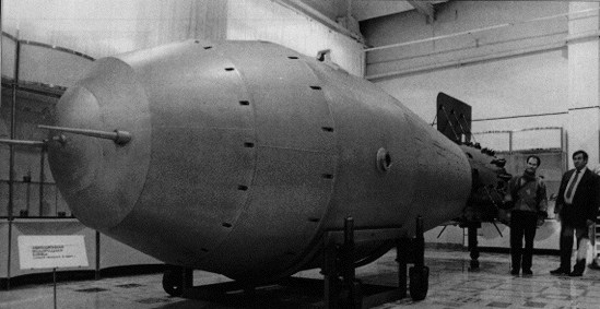
The effects were spectacular. Despite the very substantial burst height of 4,000 m (13,000 ft) the vast fireball reached down to the Earth and engulfed the ground below it, and swelled upward to nearly the height of the release plane. The blast pressure below the burst point was 300 PSI, six times the peak pressure experienced at Hiroshima. The flash of light was so bright that it was visible at a distance of 1,000 kilometers, despite cloudy skies. One participant in the test saw a bright flash through dark goggles and felt the effects of a thermal pulse even at a distance of 270 km. One cameraman recalled:
The clouds beneath the aircraft and in the distance were lit up by the powerful flash. The sea of light spread under the hatch and even clouds began to glow and became transparent. At that moment, our aircraft emerged from between two cloud layers and down below in the gap a huge bright orange ball was emerging. The ball was powerful and arrogant like Jupiter. Slowly and silently it crept upwards.... Having broken through the thick layer of clouds it kept growing. It seemed to suck the whole earth into it.
The spectacle was fantastic, unreal, supernatural.
Another observer, farther away, described what he witnessed as:
... a powerful white flash over the horizon and after a long period of time he heard a remote, indistinct and heavy blow, as if the earth has been killed!
In districts hundreds of kilometers from ground zero, wooden houses were destroyed, and stone ones lost their roofs, windows and doors; and radio communications were interrupted for almost one hour. The atmospheric disturbance generated by the explosion orbited the earth three times. A gigantic mushroom cloud rose as high as 64 kilometers (210,000 ft).
Some time after the explosion, photographs were taken of ground zero. "The ground surface of the island has been levelled, swept and licked so that it looks like a skating rink," a witness reported. "The same goes for rocks. The snow has melted and their sides and edges are shiny. There is not a trace of unevenness in the ground.... Everything in this area has been swept clean, scoured, melted and blown away."
Just for kicks, I used google maps to eyeball the scale of the weather underground hurricane maps, and drew a circle with a radius of approx 200km ("hundreds of km") just to show the size.... it's pretty crazy... as were the Russians who built such a bomb.
Attachments
Similar threads
- Replies
- 5
- Views
- 811
- Replies
- 17
- Views
- 1K
Latest posts
-

-
-
-
-

-

-
 What new series are you watching? *No Spoilers, Please*
- Latest: sengsational
-
-
