Ronstar
Moderator Emeritus
I've surveyed several dams and spillways for renovations, none of which were damaged to the extent of the Oroville spillway. I remember the engineers saying that it's best to have a wide spillway.
The absence of any expert opinions, the reference to a talk show host, and the extreme nature of the political talk gives a clue - not accurate at all is my non-expert opinion.I don't know how accurate this article is, but if it is accurate, the scenario outlined is this article is frightening:
Governor Brown: Evacuate Sacremento or One Million Could Die From Oroville Dam – Dave Hodges – The Common Sense Show
Just recently finished a book called "The Emerald Mile". It's the story of Kenton Grua (with 2 others) who set the speed record for rowing through the Grand Canyon. 37 hours! They made the run during historic flooding in 1983, which followed Lake Powell "filling up" and the dam controllers being forced to release lots of water!
There were serious problems in one of the spillways, first time it was ever used. Sounds similar, basically tore it up. The post mortem came to the conclusion that it was a manufacturing defect, a blemish on the concrete surface, which resulted in cavitation, that got it started. Once the damage started, it's a positive feedback loop, just keeps getting worse. When they repaired it, they made changes to allow for "a cushion of air" to be in the flow to avoid cavitation. Not sure how that worked, just the description.
The book covers much more than just the speed run, lots of history. I enjoyed it, though it was a slow read.
More info:
https://en.wikipedia.org/wiki/Risks_to_the_Glen_Canyon_Dam
Go down to 1983 flood and 1984 repair.
As a side note, cavitation is a problem in other areas too. For example, under certain depth and speed conditions, the screw (propeller) of a submarine will cavitate. When the bubbles collapse, they make noise. And that is one of the ways we submariners find our adversaries - we listen for the cavitation noise."Cavitation is the formation of vapor cavities in a liquid. Cavitation occurs in high velocity flow, where the water pressure is reduced locally because of an irregularity in the flow surface. As the vapor cavities move into a zone of higher pressure, they collapse, sending out high pressure shock waves. If the cavities collapse near a flow boundary, there will be damage to the material at the boundary. Cracks, offsets and surface roughness can increase the potential for cavitation damage. The extent of cavitation damage will be a function of the cavitation indices at key locations in the spillway chute and the duration of flow."
Glad you enjoyed the book as well! It's in my top 10! I think if you have done a fair amount of whitewater rafting (we have done some, but never down the GC) the sections describing the run those guys did mean more to you than if you haven't experienced the hydraulics of whitewater. Engineers and western history buffs will love this book!
As a side note, cavitation is a problem in other areas too. For example, under certain depth and speed conditions, the screw (propeller) of a submarine will cavitate. When the bubbles collapse, they make noise. And that is one of the ways we submariners find our adversaries - we listen for the cavitation noise.
I wonder how much design is put into these "emergency" spillways?
....
The absence of any expert opinions, the reference to a talk show host, and the extreme nature of the political talk gives a clue - not accurate at all is my non-expert opinion.
Sacramento is almost 70 miles from Oroville. The water would have to travel that entire distance without running off and then drown everyone in the city of Sacramento and the greater metropolitan area.
Many extreme technology failures are due to multiple failures. This is a good example.This is a unique case where they are trying minimize the increasing erosion/damage to a collapsed primary concrete spillway while simultaneously minimizing flows/ erosion to a emergency spillway. I'm not sure that design takes this scenario into consideration.
Many extreme technology failures are due to multiple failures. This is a good example.
The latest pictures from the main spillway show the new "canyon" being scoured next to and parallel to the bottom of the tailrace. I guess as long as the undermining doesn't work its way up the main spillway anymore, things might work out, assuming no major inflows that the main spillway can't handle.
But, oh boy, there are some major repairs coming. Wow.
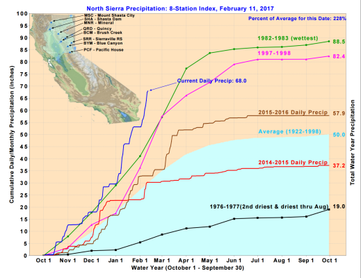
I do not understand how Nor Cal goes from horrible drought to way too much water in a few months. How did these lakes go from historicly low levels to busting at the seams!? There has been a lot of rain but only about 125% or 150% of normal. It's not like it's 500% of normal. I wish I understood this better.
I do not understand how Nor Cal goes from horrible drought to way too much water in a few months. How did these lakes go from historicly low levels to busting at the seams!? There has been a lot of rain but only about 125% or 150% of normal. It's not like it's 500% of normal. I wish I understood this better.
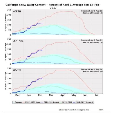
All of the big reservoirs in CA collect snow melt from the Sierras, which typically doesn't start until the spring. This year I think we've had cold storm, then warm storm, then cold storm patterns. Last week's storm was warm with rain at the high elevations. Run-off was greater due to melting snow at the those elevations as well as just the buckets of rain that have been coming down. If the snow had melted in the spring there would be plenty of time to better regulate the lake level.
I read that they are going to drop rip-rap by helicopter into the primary spillway to mitigate damage in the short term.
How did these lakes go from historicly low levels to busting at the seams!?
After years of drought, northern California has been inundated with more than twice as much precipitation as normal since 1 October. The precipitation is also coming in an inconvenient and unseasonal format: rain.
Typically, a significant amount of a winter season’s precipitation stays frozen in snowpack until spring. But this year, much of that precipitation has been rain, and even when snow has fallen, it has been melted soon thereafter by warm rains.
“It’s a double whammy,” Carlson said.
Lake Oroville typically reaches its highest level in June, after the snow melts. To reach such a peak in mid-February is “extraordinary”, Carlson said. More rain is expected later this week.
This article might help:
https://www.theguardian.com/us-news/2017/feb/14/oroville-dam-flooding-california-drought-weather
After years of drought, northern California has been inundated with more than twice as much precipitation as normal since 1 October. The precipitation is also coming in an inconvenient and unseasonal format: rain.
With all due respect to The Guardian and many other commentators, using the term "normal" is what is confusing things. For California, and most mid-latitude climates, "normal" is a large swing year to year that pivots around the mean, or average. Yes, in some years the average is hit spot on, but that's actually not a normal occurrence.
I know I'm parsing words, but I think this is where the confusion comes as to "how can this happen?" The simple fact of the matter is that when we plan our long term lives: cities, parks, roads, infrastructure, etc., we have to be ready for events far away from the mean. Because, they are normal occurrences.
The sad fact is that for this not-unprecedented high-precipitation event, the dam design was a failure. The main spillway could not handle outflows well within range. The emergency spillway basically couldn't handle anything. They designed that emergency spillway on a wish, a wish it would never get used. That's almost criminal. To see the way the earthen substrate was caving backwards towards the spillway structure astounds me. It looks like it was built on compacted earth. I'd say some swear words here, but I better stop.
The good news is they put caution to the wind on the main spillway and just let it do its thing as the tailrace deteriorates. At least that deterioration seems to be staying far away from the main control structure. Hopefully, the main spillway can handle the expected inflow of the next rain event.