Thoughts on TESLA

Status
Not open for further replies.
But when you need external data to help you brake or swerve, I have to question the capability of the system when such data is not available.
Again, it is not needed but is complementary and can avoid false positives that get corrected automatically. Seriously you are misrepresenting the information naively. Example false braking may happen but it is a very short duration and then they system realizes it was false and continues. It is not like the system 'sees' something and slams on the brakes until it skids to a stop. These system process video 1000s of times per second and can tell from one snapshot/image/frame to the next how it has changed and deduced the next steps. Lot of info as well on how multiple frames in fractions of a second can be used to determine the distance to objects (ie. size is relative, speed is relative ... to the car you are in -- examples in the Tesla videos above an online where it constantly updates the speed and location of nearby objects!). This is SDC 101 stuff that you are talking about. Watch some of the presentations in question. No, I'm not going to look all this up for you and point you to it. It is all easy to find.

Keep in mind that LIDAR does not work in heavy rain, snow, etc. It is a backup as well to radar and cameras.

uH1kXPO.jpg
 
Last edited:
Q: Like I've said time and time again in the self driving car thread, I fear these systems will lull many into complacency, and we may have even more accidents as people pay less and less attention. A: I want to see a system that forces the driver to pay attention - until we are full autonomous, no steering wheel.
I totally agree with ERD50 about any system requiring external assistance is not really autonomous, and can still be fooled.
That’s been asked and answered “time and time” again on this thread, and it’s part of the mission statement of most autonomous development teams, Waymo in particular. What’s the purpose here in drawing conclusions NOW based on systems that no one says are ready for prime time anyway? Sort of like concluding AI won’t ever work because it hasn’t yet, but knock yourself out. Every innovation was something that was possible before.
NW-Bound said:
PS. In the case of Midpack's AEB, it is a system to assist and not to replace him. And so, it is still Midpack's responsibility to keep a safe distance and brake as required. The car maker may already set the system threshold on the side to prevent false detection. And it still brakes wrongly on occasions.

Imagine if Midpack no longer has any brake pedal, or steering wheel. How more reliable the computer/sensor set will have to be? Will it be so touchy to brake for a mere shadow on the road?
For the record again, my car is level 1 and makes no claims of autopilot or autonomous capability. So it’s not anywhere near an example of what’s to come. Tesla claims they’re level 2.
 
Last edited:
It's true that I was talking about what is expected of a true autonomous car of Level 4 or 5.

I guess I got hung up on Musk's promise of a car like that, and so I wondered how the current car looks nothing like what it has to be able to do.

Should not take him too seriously, I guess. Or perhaps I misunderstood what he promised.

PS. Or perhaps Tesla fans have such great expectations that Tesla current cars can be updated to Level 4 or 5 by software, and they confuse me. I admit that I do not know what Tesla official promise truly is.
 
Last edited:
Multiple ways to detect this and deal with hard to identify places. Some of these are identified in 'tile' files for GPS coord that have a problem. A train overpass that is on the bottom of a hill in my area is one example. Also the car can 'trigger' this data feedback if it activates AEB even for a short time and the driver presses on the accelerator pedal overriding ... aha ... perhaps this was an area of false AEB so trigger an investigation (I've done this with GPA coordinates and Google streets when others have pointed it out).


Some info I wrote up for my son a while back based on research. There is a ton more to this and I'm giving an overview:


Autopilot also has ADAS (adv driver assist sys) map tiles that are fetched from a server (<geohash>.tile). Each tile covers a certain fixed geographic area (5 char geohash), and they contain information that the AutoPilot uses for assisting it's decision making (i.e. extra info besides cameras for slowing for turns as an obvious one). Tile files around your commonly driven areas are cached on the SSD in the CID (Center Instrument Display) hardware.


Google street of train overpass at the bottom of a hill.

hdw1spx.jpg


Tesla tile data (unofficial viewer of data from official geohash.tile file).

5FDso9d.jpg


Thanks for info on the tiles. Your example shows a tile that is a smaller geographic footprint than the length of the centerline segment listed. So I assume that Tesla uses tile data in addition to centerline data that everyday nav systems use.

The GPS assist to grab appropriate tiles (and possibly centerline data) may work well in the Naperville example you posted, but I suspect that this may not work too well in downtown Chicago. The urban canyons would most likely yield incorrect data- maybe not even in the correct tile. I’ve tried using gps of all sorts in the city with little luck. Hopefully Tesla needs GPS for very little assistance in areas where adequate GPS signal is blocked.

I have read that Chicago is installing repeaters in some gps blocked areas to mitigate this problem. https://www.chicagotribune.com/busi...icago-lower-drive-beacons-20180828-story.html
You are most welcome.

[update]Added example of localization explanation in a short video. Several layers, lane, 10-20cm precision within lane, etc[/update]

Each tile is made up of may data points and definitions. That map is a 3rd party (non-USA) person just interpreting the data and doing an impressive job. There are data points that make up end points of a 'spline' which are connected to make sections of roads. Each spline has attributes (meta data) associated with them. The length of them vary. I think in general they are 'centerline' as well.

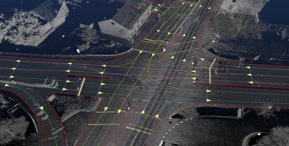
KEY POINT: Everyone is hot on 'HD maps' that layout every *lane* within the road. They keep track of the GPS coord ... scratch that ... they keep track of the X,Y,Z world coordinates of where everything is located. So when they know a particular sign is at X1,Y1,Z1 and a light pole is at X2,Y2,Z2 and they know where the car is (Xn,Yn,Zn) they know where they are at in the real word in a 3D space done to several centimeters.

Some the radar actual world 'mapping' plus surround cameras at a given point of time PLUS all the above type of information lets them know precisely where they are.

Comma.AI has a lot of public information on this as well as Mobileye.

Funny you should mention downtown Chicago because I visit Drs there sometimes and there is a difference in using Waze/Google phone GPS coordinate based mapping VS using the GPS coordinates within the car. Why?!? Because once the car knows where it is and you are using its NAV system then when it looses it's GPS signal it still knows from the point it had the signal to now how-far-it-has-traveled ... thus it knows where it is. We have found this out, as an example, in going downtown and blocked buildings or going thru lower wacker. The car still knows you need to turn in yyy miles (or feet)!

Lights and signs in this example are known in XYZ coordinates and would be in HD maps as some examples.
NGEUiR5.jpg


HD mapping example of knowing lane layouts.
High-definition-map-for-autonomous-driving.jpg


Title: HD Live Map for autonomous cars
 
Last edited:
You are most welcome.


Each tile is made up of may data points and definitions. That map is a 3rd party (non-USA) person just interpreting the data and doing an impressive job. There are data points that make up end points of a 'spline' which are connected to make sections of roads. Each spline has attributes (meta data) associated with them. The length of them vary. I think in general they are 'centerline' as well.


KEY POINT: Everyone is hot on 'HD maps' that layout every *lane* within the road. They keep track of the GPS coord ... scratch that ... they keep track of the X,Y,Z world coordinates of where everything is located. So when they know a particular sign is at X1,Y1,Z1 and a light pole is at X2,Y2,Z2 and they know where the car is (Xn,Yn,Zn) they know where they are at in the real word in a 3D space done to several centimeters.


Some the radar actual world 'mapping' plus surround cameras at a given point of time PLUS all the above type of information lets them know precisely where they are.


Comma.AI has a lot of public information on this as well as Mobileye.


Funny you should mention downtown Chicago because I visit Drs there sometimes and there is a difference in using Waze/Google phone GPS coordinate based mapping VS using the GPS coordinates within the car. Why?!? Because once the car knows where it is and you are using its NAV system then when it looses it's GPS signal it still knows from the point it had the signal to now how-far-it-has-traveled ... thus it knows where it is. We have found this out, as an example, in going downtown and blocked buildings or going thru lower wacker. The car still knows you need to turn in yyy miles (or feet)!


Lights and signs in this example are known in XYZ coordinates and would be in HD maps as some examples.

NGEUiR5.jpg


HD mapping example of knowing lane layouts.

High-definition-map-for-autonomous-driving.jpg


Some impressive stuff. I like the way that the car keeps track of where it’s at after it loses satellite lock. Many years ago, I saw similar technology explained at our surveyors conference. Case study at O’hare Airport. The little electric carts in the terminal were outfitted with GPS and something like a gyro. The carts could get gps lock in some places and then use the gyro data to determine its location elsewhere in the terminal.
 
Some impressive stuff. I like the way that the car keeps track of where it’s at after it loses satellite lock. Many years ago, I saw similar technology explained at our surveyors conference. Case study at O’hare Airport. The little electric carts in the terminal were outfitted with GPS and something like a gyro. The carts could get gps lock in some places and then use the gyro data to determine its location elsewhere in the terminal.
Thanks. Looks like you missed my update that you may like which shows/talks about how the new HD maps that *everyone* is working on and doing helps position a car in a 3D space. Below is just one of 100s of examples from companies.

[update]Added example of localization explanation in a short video. Several layers, lane, 10-20cm precision within lane, etc[/update]
Title: HD Live Map for autonomous cars
 
^ thanks - yes I did miss your earlier post. The video clears up a lot of things for me. One thing I hadn’t thought of. Once the data model has advanced to the point where 3D coordinates of signs, etc are established, then the position of cars can be checked/fine tuned by triangulating vectors from the cars to the known positions of the signs, etc.
 
Some impressive stuff. I like the way that the car keeps track of where it’s at after it loses satellite lock. Many years ago, I saw similar technology explained at our surveyors conference. Case study at O’hare Airport. The little electric carts in the terminal were outfitted with GPS and something like a gyro. The carts could get gps lock in some places and then use the gyro data to determine its location elsewhere in the terminal.

Mention "gyro" and my eyes light up. :) I spent a few years doing R&D in this field and published a couple of papers in engineering journals on this subject.

Terrestrial vehicles such as cars can use a very cheap form of navigation for momentary loss of GPS: dead reckoning using the distance traveled as measured by a wheel or drive-shaft revolution counter, with the heading of the vehicle determined using an electronic magnetic compass. Very cheap and simple. This is used in nearly all cars with a built-in GPS. The problem is the position error builds up with time, but it will work great with an intermittent reset here and there with a GPS position fix.

In the case of your airport carts, I wonder why they need to use gyros for the heading. Perhaps the earth magnetic field is distorted so badly inside the terminal with a lot of steel structure, so that the magnetometer data is no longer accurate.

And for air vehicles that have no wheels for you to measure distance traveled, enter the accelerometers. Now, you are talking "inertial navigation systems", which have been in use long before the availability of GPS. They have been around since the 1950s, although comparing the old ones to new ones is like talking about the Eniac vs. the modern CPU.

INS's are still very much in use today, in commercial airliners as well as military aircraft, even when we have GPS now. The reason is that GPS can be easily jammed, and the users cannot take any risk.

Medium-accuracy aircraft INS's run around $100K to $200K. But the much higher-accuracy ones are found in submarines. The latter have to be super accurate because GPS signal does not penetrate the ocean water, and a submarine may not be able to surface to get a position fix for a long time. Their cost was more than $1M, back when $1M was real money. Some long-range strategic bombers had these high-accuracy ones too.
 
Last edited:
I wonder if someone at Tesla monitors this thread ?
I know you’re kidding, but I think most people don’t realize how much more the serious SD teams know than we do. They’ve 99% worked out or recognized everything we’ve asked and are on to things we haven’t even thought of yet. They’re more aware of how complex the problem is than we are, and what the transition challenges will be and then some. What they share with us is the simple stuff, not the valuable or complex problems and solutions. SD will be great when its broadly implemented, that’s going to take quite a while I’d guess - hopefully before they take my license away in 25+ years...
 
Last edited:
I know you’re kidding, but I think most people don’t realize how much more the serious SD teams know than we do. They’ve 99% worked out or recognized everything we’ve asked and are on to things we haven’t even thought of yet. They’re more aware of how complex the problem is than we are, and what the transition challenges will be and then some. What they share with us is the simple stuff, not the valuable or complex problems and solutions...
+1

There's a lot of money involved, and companies like Waymo keep their cards very close to their chest. As mentioned, they keep testing and testing in my area, even driving through my residential neighborhood often. I am very curious what they are looking for, but most likely problems that I would not think of.

If they scan the public forum, it would be just to see the public sentiment about SDC. What I have read recently, the public's regard for SDC technology is not all that great, given the accidents to date. Of course, Waymo and other companies knew about the risk of that negative publicity on the technology long ago too. However, they can be very careful about what they do, but have no control over their competition.

Thought about sharing more in the other SDC thread, and I may do that yet. I need to spend time away from the keyboard to make progress on my DIY home storage project.
 
Last edited:
Mention "gyro" and my eyes light up. :) I spent a few years doing R&D in this field and published a couple of papers in engineering journals on this subject.

Terrestrial vehicles such as cars can use a very cheap form of navigation for momentary loss of GPS: dead reckoning using the distance traveled as measured by a wheel or drive-shaft revolution counter, with the heading of the vehicle determined using an electronic magnetic compass. Very cheap and simple. This is used in nearly all cars with a built-in GPS. The problem is the position error builds up with time, but it will work great with an intermittent reset here and there with a GPS position fix.

In the case of your airport carts, I wonder why they need to use gyros for the heading. Perhaps the earth magnetic field is distorted so badly inside the terminal with a lot of steel structure, so that the magnetometer data is no longer accurate.

And for air vehicles that have no wheels for you to measure distance traveled, enter the accelerometers. Now, you are talking "inertial navigation systems", which have been in use long before the availability of GPS. They have been around since the 1950s, although comparing the old ones to new ones is like talking about the Eniac vs. the modern CPU.

INS's are still very much in use today, in commercial airliners as well as military aircraft, even when we have GPS now. The reason is that GPS can be easily jammed, and the users cannot take any risk.

Medium-accuracy aircraft INS's run around $100K to $200K. But the much higher-accuracy ones are found in submarines. The latter have to be super accurate because GPS signal does not penetrate the ocean water, and a submarine may not be able to surface to get a position fix for a long time. Their cost was more than $1M, back when $1M was real money. Some long-range strategic bombers had these high-accuracy ones too.


This brings back memories of a conversation I had quite some time ago with my niece’s husband the corporate pilot and techno geek. So I texted him to refresh my memory.

He said “The model of GPS that I was flying could fly random routes across the Atlantic. The model before ours had what was called an IRS or inertial Reference System. It was pretty much a laser powered gyro but would start to drift after a while. You were only allowed to be out over the ocean for 6.2 hours before recalibrating using a ground based navigation station.

With new GPS’ installed and redundant GPS’ for back up we were allowed to fly random route instead of tracks.”

Exactly right! An INS is also called IRS.

And the medium-accuracy INS typically used in aircraft is of the so called 1-nm/hr class, according to their drift rate. They may be better now, perhaps by a factor of 2 or 3. The problem is cost.

When coupled with a GPS to reset their drift errors, the combination is a wonderful synergistic solution. It's because the INS gyros also provide pitch/roll/heading attitude of the aircraft, which is vital for aircraft flight control. And for this attitude info, aircraft normally carry 2 or 3 INS for redundancy, in case one fails.

Military aircraft use the INS/GPS combo to allow them to "cruise" through periods or areas of GPS outages caused by enemy jammers. Other means of obtaining a position fix periodically to reset the INS error growth exist, such as terrain correlator, or Dopper radar, etc...

The high-accuracy systems used in submarines were of the 0.1-nm/hr system, and the cost went up accordingly as I mentioned. When I stopped working in 2012, I was already a few years out of this field, and no longer knew what the industry was doing. Just look on the Web, and they now have 0.01 nm/hr INS for submarines.

PS. For an appreciation of how hard it is to build an INS, here's some numbers. The so-called medium-accuracy INS's must have their gyro drift rates of less than 0.01 deg/hour. The measurement units used to specify gyros and accelerometers are ppm (part per million), and micro-G (1 millionth of normal gravity), etc... RLG or ring laser gyros started to replace spinning mass gyros in the late 70s.

PPS. Solid-state gyros and accelerometers (the so-called MEMS) are in our smartphones. They are also in Chinese-built drones, and some makers have software to make a low-accuracy INS out of them. Of course, these are a long cry from having 0.01 deg/hour accuracy.
 
Last edited:
^ technology is amazing. I remember a college professor tell us “Technology is constantly changing, and the rate of change is constantly increasing”. Quite true. I expect that automated type vehicles will be available sooner than we expect. And with technology that hasn’t been thought of yet.
 
We continually make things better, smaller, and cheaper, once we know how to make it. Most of the time. But occasionally, there are things that we could not. The Space Shuttle, and the supersonic Concorde are two examples that came to mind.

And then, there are constraints from the laws of physics that cannot be violated. An example earlier is the radio waves not being able to penetrate sea water to reach submarines (except for ELF), so they had to find other ways.

Back to SDC, we know the sensors in use today have limitations. Can these work well enough for the job? If not, has anyone come up with something else?

I often wonder about these questions, being curious about what the SDC developers are doing, but was called a Luddite. :LOL:
 
^ Today's sensors have limitations, but I suspect that these limitations will be minimalized over time. SDC will evolve - like the car, like the airplane, etc, etc.

Here's a video on Musk's Tesla Tunnel.

 
I don't share people's enthusiasm about the tunnel, because I do not see how it can help solve the traffic congestion problem in cities like LA. When you want to go from point A to point B in this huge metropolis, will there be a tunnel that happens to link those two points?

And the funneling of the traffic from surface roads at the tunnel's entrance and exit will slow down the traffic movement, so how much traffic these narrow single-lane tunnels can carry compared to surface freeways? Are these tunnels cheaper than surface streets? Will they be just a way for rich people to bypass streets crowded with the plebs?

A transportation or traffic expert can examine the above points and gives us some answers. Until then, I am skeptical, and feel underwhelmed when I see what this tunnel is about.
 
Last edited:
An interesting recent video on Tesla’s autopilot, what’s really good and what’s really bad (or far from ready for prime time). Frankly, I thought Tesla AP was more evolved...

https://youtu.be/cO_1vn1ZKRM
 
Reasons to avoid playing with Tesla batteries out of the car

This guy has rebuilt several salvage flood and fire damaged Tesla's.

This video shows some of the energy stored, and what happens experimenting with home brew charging. ( another video with the postmortem states it started with one cell overheating due to overcharge.) When car geeks go too far.

 
I don't share people's enthusiasm about the tunnel, because I do not see how it can help solve the traffic congestion problem in cities like LA. When you want to go from point A to point B in this huge metropolis, will there be a tunnel that happens to link those two points?

And the funneling of the traffic from surface roads at the tunnel's entrance and exit will slow down the traffic movement, so how much traffic these narrow single-lane tunnels can carry compared to surface freeways? Are these tunnels cheaper than surface streets? Will they be just a way for rich people to bypass streets crowded with the plebs?

A transportation or traffic expert can examine the above points and gives us some answers. Until then, I am skeptical, and feel underwhelmed when I see what this tunnel is about.

Lifelong LA native here. Population of the region has almost tripled during my lifetime. TOO MANY PEOPLE. Hint: Water shortage. Nature gives hints when man does un sustainable stuff.

Tunneling and building concrete lined transportation tunnels produces lots of construction jobs, profits and ENORMOUS ENVIRONMENTAL DAMAGE LIKE CO2 FROM THE CONSTRUCTION.
 
This guy has rebuilt several salvage flood and fire damaged Tesla's.

This video shows some of the energy stored, and what happens experimenting with home brew charging. ( another video with the postmortem states it started with one cell overheating due to overcharge.) When car geeks go too far...

I linked this video earlier, perhaps on another thread about renewable energy. I also described different types of lithium batteries, and how some types are more sensitive to abuses than others. The type used in Tesla cars has the best energy density, and may be more temperamental than other types.

In a later video, this man admitted to disregarding the safety required of lithium batteries, and charging the recycled batteries with a generic charger instead of using a properly designed smart charger. He got what was coming to him.
 
Last edited:
An interesting recent video on Tesla’s autopilot, what’s really good and what’s really bad (or far from ready for prime time). Frankly, I thought Tesla AP was more evolved...

https://youtu.be/cO_1vn1ZKRM

What the video above says does not contradict videos from other Tesla owners that I saw earlier (and linked to).

Basically, Tesla AP works well most of the time. But you do not know or can tell in advance when it becomes erratic. Hence, the driver has to stay alert all the time. Yet, many owners have said that monitoring the AP is still a lot less work than actually driving, and they can drive on the interstate for a long day and do not feel worn out as with a normal car.

The above can be true, that is a semi-autonomous car can still be helpful. That in itself has been debated endlessly, and I don't think about that much anymore. Tesla owners have said it helps them, so why dispute that?

But I myself look towards the ultimate goal, that of a car without a steering wheel and brake pedal that Waymo has been working towards. I am more curious about how close Waymo is to that, and what problems they are still working on. The more I understand a technical problem, the more I appreciate the hard work, and admire the guys who solve it. As in any field, an outstanding achievement by a worker is appreciated more by his peers than by the public.
 
Last edited:
Status
Not open for further replies.
Back
Top Bottom