Poll: Google, Tom-Tom, Apple, Waze?

Which GPS map do you prefer?

  • Google

    Votes: 69 58.0%
  • Apple

    Votes: 17 14.3%
  • Waze

    Votes: 29 24.4%
  • Tom-Tom

    Votes: 2 1.7%
  • Garmin

    Votes: 12 10.1%
  • Paper

    Votes: 4 3.4%
  • Wife

    Votes: 4 3.4%

  • Total voters
    119
  • Poll closed .
I love paper maps. Just like I love the feel of paper (news)papers. I mean they're more foldable than phones and tablets. Another good thing about paper papers are that they force me to get semi-dressed to go out and retrieve them. We don't have a dog.

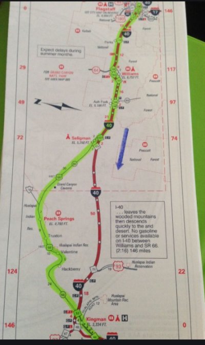
I was digging through some boxes that had stuff stored and came across some "TripTiks" from AAA. My Mom would get them for my trips between duty stations while in the Air Force and back home. It was cool how the AAA agents would highlight areas where there were speedtraps or where there was aggressive speed enforcement. It brought back some great memories...and I often would love to go back to a simpler time.
 

Attachments

  • triptik.jpg
    triptik.jpg
    95.4 KB · Views: 8
I tend to switch between Apple (Apple Watch makes it a breeze), Waze and the Garmin in the head unit I put in my truck a few years ago. When I go back home to West Virginia, the Gamin's built in maps make it nice as there is no cell phone service for data and some roads only hint at being visible. Welcome to Appalachia. Amazingly those traces of roads show up on the Garmin. It actually shows partial roads we can only run a tractor on to move between fields in the hollows. I was shocked.
 
I use a non mainstream navi software called HERE We Go.

It can be used online or offline (and I only use it offline). The maps are free and update quite often (once every couple of months). The app itself is free. Perhaps it is pretty bad that no one mentions it but I found it is straight forward to use.

I started using it back in 2014 on a windows phone and now on the android system for both my phone and the aftermarket stereo head unit I put in my car. From google search I understand it is also available for iphone so it remains a puzzle to me why a free navi software with free offline map download and update doesn't get more attention..

I use it too, on occasion. Good maps and it seems to be the underlying software for the navigation system in my Volvo. I can even use it to send destinations to my car, which is a little more convenient than using the car's interface for that.
 
FWIW- To its credit, Hyundai (USA & Canada at least) is currently providing its (original?) car owners with free NAV unit updates via website download. (How long that may last, who knows).
Many automakers are doing this, but it’s a half measure at best. Subaru (TomTom) provides free updates for 3 years, but it’s a PITA. Create an account online (with all your personal info of course), download updated software, upload update to USB, plug USB into Subaru and wait 20-30 minutes (with the car running) for update to complete. And then it’s still way behind on map data. The Subaru TomTom NAV system is the worst and the voice recognition software works about 10% of the time - get used to hearing “I didn’t get that” from your Subaru.

Honda (Garmin) also provides free updates, and the system is less cumbersome than Subaru, but it’s still inferior.

OTOH, Google and Apple Maps update constantly, and seamlessly. Way more up to date than ANY automakers built in NAV. I would NOT buy a car that didn’t have CarPlay and Android Auto anymore.
 
Last edited:
I read a while ago that CarPlay (IOS12 and later) offered functionality where a user can predefine their own route to go somewhere. And then that is the route that is used for car navigation.

I read about it online in a Route 66 discussion group. So say you want to drive from Chicago to Flagstaff, but you want to take Route 66. The nav system would take you along US 66 instead of interstates.
Apple Maps/CarPlay usually offers me 2-3 routes to choose from. But then so does Subaru/TomTom and Honda/Garmin. You have to wait a second, usually one pops up quickly and the others come after 10-15 seconds IME. And if I want to go a certain way I’ll just head that way and NAV will recalculate to accommodate. Or if your preferred route is unknown I plug in an intermediate destination until I get to “route 66” and then enter my final destination once I’m on “route 66.” FWIW
 
Last edited:
^ That would work. The example I thought I saw was - you plot your own custom course on Google maps on your computer and save it as a file. Then import it into the car nav system and the car follows that custom route.
 
Many automakers are doing this, but it’s a half measure at best. Subaru (TomTom) provides free updates for 3 years, but it’s a PITA. Create an account online (with all your personal info of course), download updated software, upload update to USB, plug USB into Subaru and wait 20-30 minutes (with the car running) for update to complete. And then it’s still way behind on map data. The Subaru TomTom NAV system is the worst and the voice recognition software works about 10% of the time - get used to hearing “I didn’t get that” from your Subaru.

Honda (Garmin) also provides free updates, and the system is less cumbersome than Subaru, but it’s still inferior.

OTOH, Google and Apple Maps update constantly, and seamlessly. Way more up to date than ANY automakers built in NAV. I would NOT buy a car that didn’t have CarPlay and Android Auto anymore.


Right. For our 2017 Subaru Outback with Starlink, I had to download their software, remove the SD card from the car, then run the software and update the SD card from a computer. Not tedious, but I'd always forget until I was in front of a computer, in my home, not while I was in the car. More work than Google Maps, for sure! :LOL:
 
Ha ha, we use the built-in Tesla navigation (which must be Google maps with some Tesla specific navigation built on top), and it works well overall. But for tricky or confusing areas we simultaneously run Apple Maps on a phone because their turn by turn instructions are outstanding, particularly alerting you when one turn is followed quickly by another.
 
Last edited:
Any current thoughts on Google maps vs Apple Maps vs Waze for long distance road trips?

Just did a long road trip. Did not use Waze, so cannot comment, but Apple and Google both are dynamic and time sensitive based on closures, traffic, etc. Nothing to back this up, but Apple seemed to be more straight forward - ran it on board. Google was on my wife’s phone and seemed to give us a bunch of turns and off and on interstates to save a minute.
 
Any current thoughts on Google maps vs Apple Maps vs Waze for long distance road trips?
They all work very well IME. Waze still has the most complete and current traffic info which can be more helpful, but IME Waze will heat up your phone and use more battery than Google or Apple Maps. I’m not keen on Googles data mining practices, so I never use it anymore. Once Google bought Waze I stopped using it also same reason. Apple Maps works fine, way more current maps than the built in NAV in our Honda (Garmin) and Hyundai (TomTom). I don’t know why anyone would use built in NAV anymore, their maps are always out of date and updates are a PITA.
 
Last edited:
Apple Maps works well enough for me. I try to avoid Google when possible. I will use them for looking up restaurants or when traveling internationally, even though Apple has gotten better for international maps. Depends on the country though.
 
Did some driving (about 1500 miles total) recently. Relied mainly on a used Garmin with updated maps. It got me from point A to point B. Not perfect but worked. I set up ahead of time to avoid some interstates that were closed due to construction.
 
I don’t know why anyone would use built in NAV anymore, their maps are always out of date and updates are a PITA.
Not only that, but on my '22 Subaru, I find it nearly impossible to give a destination that they understand. I can get it to direct me home, but anything else requires some specific order of address elements, and it seems I cannot give the name of a business and city and have it work.
 
I prefer Google maps. Much less battery usage than Waze. They seem to have gotten better with rerouting when traffic conditions change.
 
when we traveled in the motor home i’d use the built-in GPS especially if we were in unfamiliar tertitory. if were in bad weather i’d have a wx radar app running on the tablet and Waze just tracking us for traffic hazards on the phone.
 
Not only that, but on my '22 Subaru, I find it nearly impossible to give a destination that they understand. I can get it to direct me home, but anything else requires some specific order of address elements, and it seems I cannot give the name of a business and city and have it work.
Interesting. Is it still using OnStar? Our 2017 Outback isn't quite as bad as that, but the only methods I use are that and Google Maps on my phone, and I've noticed that Google Maps is always closer with the ETA; OnStar tends to be further off, and adjusts it much later in the trip.
 
Interesting. Is it still using OnStar? Our 2017 Outback isn't quite as bad as that, but the only methods I use are that and Google Maps on my phone, and I've noticed that Google Maps is always closer with the ETA; OnStar tends to be further off, and adjusts it much later in the trip.
I'm not sure what it's using.
 
I use Waze when I'm going to someplace I know or long highway trips because the traffic and speed traps are easy to see. If it's to a new location in a city I like Google's view including buildings at intersections. Either way I'm plugged in and watch on the nav screen in our cars so I don't worry about draining the battery or having or look at the small screen.
 
I tried to use Google maps in portions of western Colorado and Nevada last year. Lack of cell service made it impossible. So I depended on my old Garmen.

Please don’t tell me I can download maps ahead of time. The rockslide that forced a detour doesn’t care about what I downloaded earlier that day.

Been years since I used one - does the Garmin have real-time traffic and road conditions? If so, how does it stay current outside areas with cell service?
 
Last edited:
I tried to use Google maps in portions of western Colorado and Nevada last year. Lack of cell service made it impossible. So I depended on my old Garmen.

Please don’t tell me I can download maps ahead of time. The rockslide that forced a detour doesn’t care about what I downloaded earlier that day.
We use Copilot. All maps are stored locally and many countries maps are available. Currently I have the US and Canada loaded. I have also bought Europe and download needed countries when we travel.
 
I tried to use Google maps in portions of western Colorado and Nevada last year. Lack of cell service made it impossible. So I depended on my old Garmen.

Please don’t tell me I can download maps ahead of time. The rockslide that forced a detour doesn’t care about what I downloaded earlier that day.

Is it possible you misunderstood the system? Having downloaded Google maps means that cell service is totally irrelevant. It's all on your phone, so it can show you an alternate route without issue. You're not downloading just routes, but rather complete maps of an area (which can cover an enormous amount of territory).
 
Back
Top Bottom