ownyourfuture
Thinks s/he gets paid by the post
- Joined
- Jun 18, 2013
- Messages
- 1,561
I've always been a weather fanatic, especially when it comes to tornadoes.
I'm not a meteorologist, but I've attained enough knowledge to be comfortable chasing them.
I doubt they'll be much interest in this, but what the heck.
Sunday July 9th 2017
Recap: The atmosphere where I live (South Central Minnesota) was capped that day.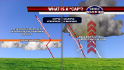
There's plenty of sites that identify area's where severe weather is most likely.
I use this one, https://www.wunderground.com/severeconvective.asp?outlook=today & on July 9th, there was a large area highlighted in dark orange (enhanced risk) to the NW of me.
I left around 4:45 PM, zigzagged on a bunch of different roads until I was approximately 75 miles NW. I pulled into a field approach & watched.
Lots of little cells were trying to start up to the east & south of me, but as mentioned earlier, the atmosphere there was capped.
About 1/2 hour later, I saw two separate storms to the NW break through the cap. I followed the one furthest west. It's amazing how fast a fluffy little cumulus cloud can turn into a supercell when all the conditions are just right.
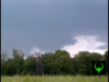
I am guessing that the time between when I saw this little cell go up, & when I started recording, (pic 1) was 30 minutes tops!
A couple things about this storm were amazing to me. One was the sound of the thunder from 7:55 to 8:05. I can only describe it as the sound of giant boulders rolling downhill. The other was the beautiful striations in the storm caused by the spin/rotation visible from approximately 6:30 & forward.
Most visible in screen-cap 6. It was simply incredible!
My only regret is that I procrastinated on getting an HD camera. I can only imagine how much better the caps/video would've looked


I'm not a meteorologist, but I've attained enough knowledge to be comfortable chasing them.
I doubt they'll be much interest in this, but what the heck.
Sunday July 9th 2017
Recap: The atmosphere where I live (South Central Minnesota) was capped that day.
There's plenty of sites that identify area's where severe weather is most likely.
I use this one, https://www.wunderground.com/severeconvective.asp?outlook=today & on July 9th, there was a large area highlighted in dark orange (enhanced risk) to the NW of me.
I left around 4:45 PM, zigzagged on a bunch of different roads until I was approximately 75 miles NW. I pulled into a field approach & watched.
Lots of little cells were trying to start up to the east & south of me, but as mentioned earlier, the atmosphere there was capped.
About 1/2 hour later, I saw two separate storms to the NW break through the cap. I followed the one furthest west. It's amazing how fast a fluffy little cumulus cloud can turn into a supercell when all the conditions are just right.
I am guessing that the time between when I saw this little cell go up, & when I started recording, (pic 1) was 30 minutes tops!
A couple things about this storm were amazing to me. One was the sound of the thunder from 7:55 to 8:05. I can only describe it as the sound of giant boulders rolling downhill. The other was the beautiful striations in the storm caused by the spin/rotation visible from approximately 6:30 & forward.
Most visible in screen-cap 6. It was simply incredible!
My only regret is that I procrastinated on getting an HD camera. I can only imagine how much better the caps/video would've looked
Last edited:
