Epic Road trip in November!

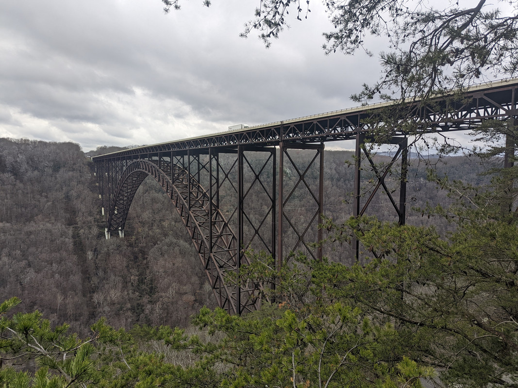
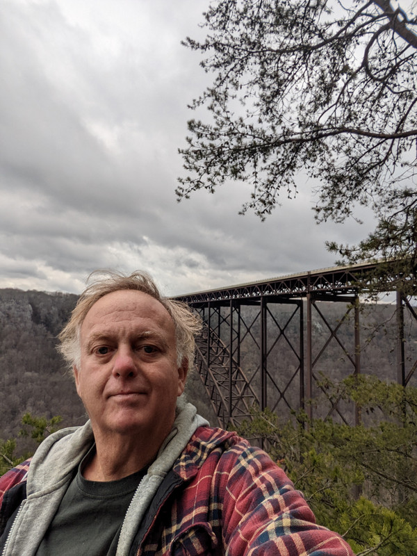
New River Gorge seems cool, that might be a stop along the way. What say you O wise travelers of this country?

We love that area, The bridge is is awesome... If you got the brass ones see if the walkway is open. I have to stay off the back roads... I would be stopping at every front porch playing music...
Enjoy your trip
 
This can serve as a current picture post and an update on the travels. The young lad is seeking some comfort under my arm for a moment.
IMG-0350.jpg

We are in Omaha for lunch. Wyoming was epic windy, as is Nebraska. Things are going well after a rocky start on move day. We are running ahead of any precipitation, after just a little rain in the Columbia Gorge on Saturday night.

On our Glamping trip this past May/June we were really surprised at the wind, always blowing, harder at times but always there in Nebraska,Wyoming,& S.Dakota. Pulling our 5th wheel into it would at times feel like a big hand slamming against the front, then go around a big curve and it hits the side, scaring my DW that we might be turned over. Good luck on your continued moving journey.:greetings10:
 
Now I've got a decision either south through Harrisonburg on highway 81 and then over to New River gorge, or right over into West Virginia and down 68 through Morgantown.
 
If you are in Amish PA country I assume you mean Lancaster County (Bird in Hand, Intercourse). There are several ways to go. Highway 30 will take you right through Gettysburg and there is much to see there. Even if you don’t do a battlefield tour, since that takes a lot of time, you might want to check out David Wills House, a museum on Lincoln Square in the heart of Gettysburg. It is a small museum but has historic significance as Lincoln spent the night before his Gettysburg address putting finishing touches on his speech.

Highway 30 meets up with Highway 81 in Chambersburg. Although 81 is a major trucking route, it isn’t too bad a drive. In Virginia the speed limit is 70 so trucks will be going 80. I live 1/2 mile from 81 west of Harrisburg PA and DS went to college in Harrisonburg, so we know that stretch of Highway fairly well. It’s a good road, straight, with open sky and mountains to your west, but the trucks can be a bit much. It’s mostly rural in that stretch so traffic isn’t bad. I can’t comment on the WV route, as I haven’t done it.
 
Since rejoining with DW she has done a bunch of the driving on the interstates. We make a good team. When I brought home the manual transmission truck she jumped up in there and started rowing gears and said let's go to town. All she cared about was it wasn't a fat butt or a long bed :)

It pretty cold driving through Western Maryland in the mountains and down into West Virginia. It was spitting snow and about 30°. I was really expecting that more in the Rockies lol.

I walked down about 100 steps of like this to get a good view of the new River gorge bridge. Needless to say I was on my own.
PXL-20221113-203215104.jpg

PXL-20221113-203542409.jpg


PXL-20221113-203611005.jpg
 
Do they still have the huge terrain model in the welcome center?
 
They have a big interactive walkthrough with a little theater. I only saw a small display like you're talking about. Maybe 4 ft long. It was definitely nice to stop by and get a feel for it, will be back when we have time to make reservations for the accessible tour.
Sometimes the coolest things you just stumble on. This time. It was the ferry across the Green River that's inside the park operated by Park personnel.
It was by no means the fastest way anywhere, but the ferry operator said it took you to a little Amish community with a country store. We picked up jams jellies and pickles for the upcoming Thanksgiving and just had a great country drive.
 
We spent around a week every year at Cliff Top for a music festival. We got to explore alot of the area.. old back roads and towns, old coal mines... the old town of Thurmond was awesome.
 
This is all good seed for a return trip. We went to the national quilt museum in Paducah and were really impressed. There was a big display about the civil rights movement and other subjects that we were not expecting.
 
We are back home after 22 states and 8500 miles.
After we left Paducah we went to Hamilton, visited with forum friends in Missouri and Kansas, stayed with another near Denver and made a plan for Utah based on his extensive experience as an oil field engineer.
The drive across Colorado started out with inclement weather and cold. By the middle of the state it cleared up in time to really enjoy the drive through Glenwood Canyon. We hit Utah in the early afternoon and made the drive through Castle Valley along the Colorado river to Moab. If you follow google it will take you down I-70 and bypass that really scenic drive down 128 along the river.
The next day we blew right by Arches National Park on a special adventure. We will see arches when we come back.
Our friend sent us across the Burr trail, a 60 mile paved and gravel route across the southern end of Capitol Reef National Park. It was the high point of our time in Utah.
We had enough daylight left to get to Bryce Canyon and see the highlights.
 
The next day we took in Death Valley and on the way to our next stop, we were buzzed by a private ex-military jet in the desert. It was a perfect thrill for this pilot!
Once again we took the road less traveled, and dropped down the Kern River canyon from Lake Isabella. That drive is a little daunting, even moreso than the Burr trail.
One of the stops was at DW's SIL to get some things from her departed brother, in the countryside north of Paso Robles.
We drove across the Golden Gate bridge and checked that off the list on our way north, and then today the weather was picture perfect all along the Oregon coast on the last run for home.
I took a ton of pictures and video, and will get to editing that down.
 
^^^^^

Sounds like quite a trip. Looking forward to some pics and stories. Welcome home.
 
Out of Moab we blew right past Arches National Park on another adventure. Our friend looked at the timeline and the equipment we had, and sent us up a road called The Burr trail. It is 60 miles of payment and gravel that pass through Capitol Reef National Park.
On the way we stopped at this little hole in the wall convenience store and gas station.

PXL-20221119-165456982.jpg

Bathrooms through here. Watch your head.

PXL-20221119-164935608.jpg

We drove across a couple of really deep slot canyons that I didn't get a picture of because we were on them in a hurry.
I had called the Escalante visitor center to get road conditions for the Burr trail. Up until recently it had been passable for two wheel drive vehicles, but the washboard was pretty bad going uphill. After I'd gone through and looked at it, you could take any car down it as long as you're going west to east. The kicker is a wash at the very beginning of the East end that could be impassable without four-wheel drive. Look before you cross!

PXL-20221119-181905950.jpg

The road starts out paved and is in pretty good shape. It climbs right up to give some beautiful views of canyons below.

PXL-20221119-183444735.jpg
 
Last edited:
Welcome home. It sounds like you had a wonderful trip and some great sightseeing.
 
We did. 4 national parks and many mountain drives outside of the parks that were spectacular and best done without a travel trailer attached. We crossed the Golden Gate bridge.
 
This sign was below the switchbacks and gives you an idea of the scale of Capitol Reef. We could spend two days on the gravel there.
PXL-20221119-190419718.jpg

Here are some images from that canyon drive down. This sign is for context, you can look it up and they were the ones we called for road conditions. You could easily take a road bike or sedan in from the west end of the Burr trail and see all that, drive all the way to the top of the switchbacks and then turn around and go back out. I would recommend it!
PXL-20221119-192415306.jpg


PXL-20221119-194649882.jpg


PXL-20221119-195253822-1.jpg


PXL-20221119-195342956.jpg


PXL-20221119-195359686.jpg


PXL-20221119-200107233.jpg


PXL-20221119-200633623.jpg


There was still enough light left to get a taste of Bryce Canyon national park.
Natural bridge
PXL-20221119-223348748.jpg


big raven beggar bird

PXL-20221119-230043497.jpg


Views from Inspiration point and Rainbow.

PXL-20221119-224903846.jpg


PXL-20221119-224814399.jpg


PXL-20221119-224831436.jpg
 
Last edited:
Stunning pictures; thanks for sharing!
 
After we got through death valley we were on the other side of the mountain heading north for China lake where the naval Air station is.

We just spotted a couple of wild donkeys and a radar antenna out in the desert, and those distracted us from the approaching jet.

If I'd have seen him coming in the mirror I would have deployed countermeasures!!

It was a silver red and black Fouga Magister.

Belgium_Fouga_Magister.jpg


he passed me on the left and crossed in front of us, about 150' AGL and 250 knots. It was perfect!

THAT experience made your trip worthwhile! What a great pic.:greetings10:

I've spoken to several folks on our Island who were kids during the attack on Pearl Harbor and they saw Japanese pilots in similar kinds of attitudes. Some even exchanged waves! (some of these same kids were eventually interned in the western USA.)
 
I did not take that pic, it is representative of what I saw. He did sneak up on us after all :D
 
Mesquite flat sand dunes, Death Valley national park
PXL-20221120-214618488.jpg

The eastern mountains that define Death Valley. Note the deep shields of soil that resemble glaciers, pouring down the slopes out of the mountains.

PXL-20221120-214607093.jpg
 
In the morning we took the long way to my wife's sister in law's place to get some things that she thought my wife might like from her late brother. *He lost the battle with prostate cancer last May.
We drove up to Lake Isabella and then down the Kern River canyon towards Bakersfield. It is a pretty daunting drive down a narrow canyon, and I was glad we were not towing a trailer.
PXL-20221121-152450087.jpg


PXL-20221121-152849660.jpg


PXL-20221121-153827662.jpg


PXL-20221121-152713038-1.jpg
 
Back in 2010 when I made my 1st ever RV trip, we visited Zion and Bryce Canyon NPs.

We skipped Capitol Reef NP and Escalante because we did not have time. I just now learned how bad the road there is.
 
Not really. The normal road into the park is paved and not very long. It just does not show as much as there is.
A person can take any car to the top of the grand staircase and back down without driving on gravel.
 
Back
Top Bottom