Poll: In Car NAV preferences

Which type of in Car NAV system do you use?

  • Manufacturers BUILT IN NAV system (Garmin, Tom-Tom, other)

    Votes: 30 14.1%
  • iOS/Android/Other Smartphone Map App (Apple, Waze, Google, other)

    Votes: 140 65.7%
  • A standalone Garmin, Tom-Tom or other GPS

    Votes: 25 11.7%
  • I rarely/never use in car GPS

    Votes: 18 8.5%

  • Total voters
    213
My 2020 124 Spider came "GPS-enabled." That means if I would have paid about $500, the dealer could have enabled the car to give me directions. The part they don't tell you is that the GPS is already active in the car, there just aren't any maps to go along with it. It would give lat/long/altitude, but nothing else. The dealer would take your money and download the latest maps into the car if you paid them. OR, the option I took, was to pay $30 on e-bay for the SD card, insert into the car, and have a fully functioning GPS with directions.
 
The old standalone Garmin I used to use (sitting on the dashboard) was subject to a lot of quirks due to whatever database they had. I'll never forget one time I was in some remote part of the country and looking for breakfast. There was supposed to be a Panera about three miles away, so I let it direct me. Fifteen minutes and about twelve turns down lonely roads later, I came to an empty lot with some construction equipment on it and a sign that said "Coming soon: Panera".
:facepalm: :LOL:
 
My new BMW is easy to switch between the car’s nav system or Apple CarPlay. I do like the car’s system because it uses the heads up display to show turns, which lanes to be in and names of roads. It includes traffic information and the maps update automatically. It’s by far the best car system I’ve used.
I can also choose CarPlay to use Waze or Google Maps or Apple Maps should I want to.
 
I do like the car’s system because it uses the heads up display to show turns, which lanes to be in and names of roads.

Same with my Volvo. I really wouldn't want to buy a car without a HUD. It's amazing how useful it is.
 
I use google android auto and wife uses apple car play.

Google is better so far. Less errors and less dropouts.
 
I use an old, reliable Garmin Nuvi as my GPS.

Fits me well like an old, trusty pair of sneakers :popcorn:.
 
I like my Garmen for several reasons. First, the maps are already on it, so lack of a cell connection is not a problem. Yea, Google let's you download maps, but that only works if you know ahead of time and have a good connection. Besides, I have lifetime free maps with the device.

I also like have a dedicated mapping device that is not linked to all the other stuff a phone does. I tried using my phone for a while but found that incoming calls and other phone tasks ended up fighting for real estate on my screen. I tend to ignore my phone especially when it demands my attention. Having the Garmen lets me easily do that.
 
I voted phone apps, but that is not entirely true.
My truck is a 2009 and does not have a screen at all.

But our Lexus does and we often do use its built in maps for a lot of our travels.

So in my case, I would have needed to select 2 options.
 
It probably has CarPlay, just plug your iPhone into a USB port in the car (may be able to use charge cable). Did a search for you…

https://youtu.be/Yatf9H11jQM

Thanks for the video but I looked into it and Carplay is not available for my 2019 Lexus RX. Would have to have a 2020 or newer. Maybe I will just update my built in GPS, I use it a lot.
 
A no brand android head unit with Here app and their free offline maps works the best for me.

I don't want any cellular network because they are expensive and after I grow dependency with the data such as map, voice navi, and traffic updates, I will suffer when I am in an area without the connection.

Nav with offline maps is the way to go for me. I also can not stand waze keeps bugging me like the only way to survive (from driving?) is to join their social network.

I also don't think the connector apps like android auto are necessary (yeah I am looking to be unpopular here). Keep your phone asleep and just let the head unit handle all the things except relaying hands-free phone calls. Only a complete and unrestricted android head unit supports what I want.
 
Last edited:
My new BMW is easy to switch between the car’s nav system or Apple CarPlay. I do like the car’s system because it uses the heads up display to show turns...

I noticed that in our new Kia Telluride too. The HUD is just so nice. Beside nav I love seeing the speed limit displayed up there next to the current speed and the blind spot warning is up there to see whenever it kicks in.

I also like the built in Nav system for when I'm just driving around, not navigating. No need to plug in the iPhone (few cars have wireless CarPlay yet, certainly not our Kia...)). I view the always on nav was situational awareness - ah, I'm on First street here and am upcoming up on Maple.

That said, I do prefer Apple Maps for trips. I too hope that the crowd sourced [-]speed traps[/-] hazards in Maps catches on. I will use Waze on a trip through unknown territory to be aware of [-]speed traps[/-] hazards, but I hate the fact that Google is monitoring where I go.
 
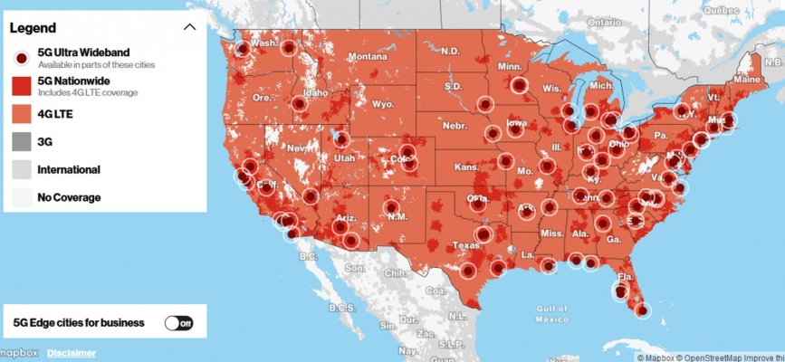
We're on the Verizon system (DW insists), and I've almost never driven anywhere that I didn't have coverage, I've never had Waze or Apple Maps drop out on me that I recall. The only times coverage is spotty is occasionally when I'm on foot way out somewhere hiking or the like.
 

Attachments

  • Coverage.jpg
    Coverage.jpg
    343.9 KB · Views: 16
Last edited:
That said, I do prefer Apple Maps for trips. I too hope that the crowd sourced [-]speed traps[/-] hazards in Maps catches on. I will use Waze on a trip through unknown territory to be aware of [-]speed traps[/-] hazards, but I hate the fact that Google is monitoring where I go.
As I mentioned in an earlier post, with iOS 14.5 and later, Apple Maps has the same continuously updated user sourced construction, police, accident as Waze has. I used Waze for the same reason with the same reservations, but I deleted Waze the day we updated to iOS 14.5.

Google monitors more than just where you go. While Apple does 1st party data collection (on it's apps only, without selling your data), Google, FB and most if not all free apps do 2nd (on it's apps, sold to others) and 3rd party (on other apps, also sold to others) data collection - constantly monitoring you through every possible app you use, not just Google products or FB. That's what the current Apple v Facebook IDFA flap is all about, FB doesn't want users to be able to choose to opt out of 2nd/3rd party data collection. Apple lets users decide. FWIW
 
Last edited:
but I hate the fact that Google is monitoring where I go.
No worries, "they" wouldn't misuse the information :(... If "they" would then there's the cell phone network that can track your cell phones location "or" the camara's that are everywhere along with license plate readers that can keep up with you. The list goes on, like on-star, lo-jack, other GPS tools, etc.... Lot's easier ways today than having to track you down by something as old school as credit card usage... But then, it's all for the good, right?


Speaking of Nav systems, I've got an old hand held Garmin (at least 15 years old) that I still use occasional... Not for so much for navigating roads, but if you are a fisherman or hunter and want to find that "exact" spot again on land or water it will get you there. I've seen the accuracy of it down to about 12 to 15 feet... And that's using 15+ year old, hand held technology...
 
Last edited:
Garmin for me. Used one for years and even it found abandoned oil wells when the oil companies couldn't locate them. Sill use it on driving trips. :cool:
 
Garmin for me. Used one for years and even it found abandoned oil wells when the oil companies couldn't locate them. Sill use it on driving trips. :cool:


Same here. On-dash Nuvi (3590, maybe?) with lifetime maps. When out of the car, Apple Maps fills in nicely.

I haven’t found any oil wells though.
 
I like the built in Nav on my Avalon, it does dynamic map updates as you're driving but that 'free' update service is only good for the first 3 years. Not sure what I'll do when that time is up, doubt I'll pay to continue with the dynamic updates.
 
We both use Google Maps for navigation. In our 2019 Subaru Forester, we use it with Android Auto. Our other 2 vehicles are very old and don't have display screens. So we just use it on our phones in those vehicles. They both have magnetic dash mounts that work very well.

We've messed with Waze several times and it does have some interesting features. But we just find Google Maps to be more reliable and easier to use. It will keep navigating without a cell signal, and without downloading maps, by buffering map data along your planned route.

We use navigation even if we know where we're going, especially when we venture into the DFW metroplex. The real time traffic data has saved our bacon many times. I also like simple things like a very precise arrival time.
 
Google maps and Waze are much better than the built in systems but they're are times you won't be in cell coverage that an app with built in maps can save you. I've got Copilot for those situations. Apple's navigation is a poor third choice vs Google and Waze.
 
We're on the Verizon system (DW insists), and I've almost never driven anywhere that I didn't have coverage, I've never had Waze or Apple Maps drop out on me that I recall. The only times coverage is spotty is occasionally when I'm on foot way out somewhere hiking or the like.

Midpack, I spend a lot of time in the NC mountains and there are many roads with no cell service whatsoever. Verizon is by far the best but there are places where you cannot receive even a Verizon signal. I am always amazed that a tourist road like the Blue Ridge Parkway has so many stretches with no cell signal. It is a safety issue. A couple of summers ago we saw a car that had run off the Blue Ridge Parkway down a steep hill. We had to drive several miles to get a cell signal to be able to call 911.
 
I seldom use mine.

Why should I pay large amounts of money to update the nav maps when the $120. Garmin unit that I bought five years ago included free map updates. Plus, it is portable....I can use it in both vehicles or in a rental. Not to mention the map apps that are available on my phone.

Given the choice, I would never pay and extra dime for a car with nav. Worthless.
 
Last edited:
Midpack, I spend a lot of time in the NC mountains and there are many roads with no cell service whatsoever. Verizon is by far the best but there are places where you cannot receive even a Verizon signal. I am always amazed that a tourist road like the Blue Ridge Parkway has so many stretches with no cell signal. It is a safety issue. A couple of summers ago we saw a car that had run off the Blue Ridge Parkway down a steep hill. We had to drive several miles to get a cell signal to be able to call 911.

The last road trip we did in 2019, we had miles of dead zones in CO, UT, NV, AZ. I even lose service locally when driving over the bridge that connects us to San Diego.
 
My standalone Garmin has been acting flaky lately- if I plug it into the dash outlet and it needs charging, the "Charging" screen may display for 5-10 minutes and I can't get it to tell me how to get where I'm going till it reverts to the normal display.

I've started using Waze more often. It needs an Internet connection to start but after that seems to do OK if I turn off Cellular Data. Last time I went through Nashville and used Waze for the first time it routed me AROUND Nashville on Briley Parkway. The Garmin always sent me through Nashville on I26/I40 and it could be awful. I thought maybe Briley would be miles out of the way or too congested but the difference was astounding.

The Honda Civic I bought last year wasn't hoity-toity enough to have a built-in navigation system and I'm perfectly happy with that. I do have my phone paired with the sound system so Waze messages come through the sound system and it automatically interrupts any podcasts I'm listening to, then restarts them.
 
My standalone Garmin has been acting flaky lately- if I plug it into the dash outlet and it needs charging, the "Charging" screen may display for 5-10 minutes and I can't get it to tell me how to get where I'm going till it reverts to the normal display.

Don't feel too badly; I think many of us got suckered into their promise of "Lifetime maps and traffic updates".

That just meant the lifetime of the unit, and with its limited battery life that's a challenge. I actually bought a replacement battery for mine some years ago but the process of opening the unit and replacing the battery was so difficult that I never did manage to get it back together perfectly. Eventually I gave up because it was so much better to just use the in-car system or my phone.
 
Don't feel too badly; I think many of us got suckered into their promise of "Lifetime maps and traffic updates".

The problem I had with my old TomTom unit with lifetime maps is that the newer maps got so large they would no longer fit on the unit. Had to install sectional US maps to get any use out of it.
 
Back
Top Bottom