Ike......here we go again

love the forecast ht harry. where are you (you mentioned within forecast) btw?


Htown = Houston.

Since inquiring minds want to know, here is some narrative and a few maps that show some of the things we'll be watching for in the greater Houston area.

We live about 50 miles inland, not far from downtown in a neighborhood about 50 feet above sea level and a generous distance away from the nearest creeks (bayous in the local vernacular). No worries for my own safety at this location unless the storm gets to Cat 4 or Cat 5.

The 10pm forecast has Houston's odds up to 80% for TS winds and 25% for hurricane-force winds. Ominously, the forecast track has moved to the north.

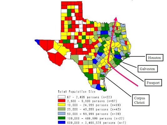
The first map shows the 6 pm forecast track laid over a map that shows Texas population density.

The good news in that map is its forecast track misses Houston, the other Texas metropolitan areas and the largest coastal towns. If the storm takes a path near Matagorda Bay and then hooks right, the most populous area in the storm track is the Bryan-College Station area northwest of Houston.

The bad news is that the Houston-Galveston-Freeport area will likely be on the wet and windy side of the storm, where the higher tides occur.

One worst case scenario, now looking a bit more probable, is for the storm to hook to the north before making landfall, striking somewhere near Freeport as a category 3+. If conditions are exactly right, that would bring a big storm surge into Galveston Bay at high tide and the highest-intensity winds through Houston. This is more or less what happened in the early 1960's with Carla. A much weaker Alicia (Cat 1 or 2) took a similar path in the early 80's, but didn't have the power to create a significant storm surge.

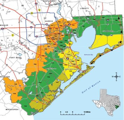
The evacuation planning map shows the areas that can be directly affected by the storm surge or related coastal flooding. From the coast to about 100 miles inland, the generally topography is extremely flat. Typical grades are only a foot or two per mile.

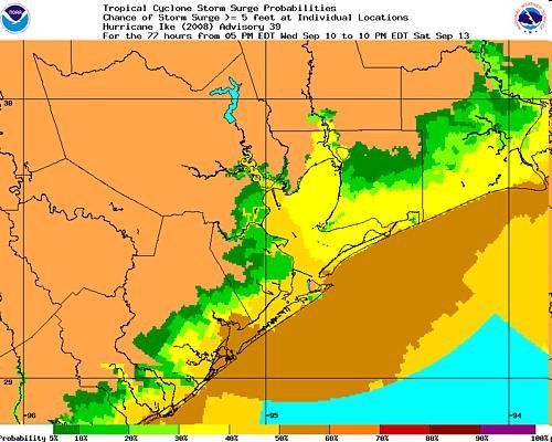
The last map is one to watch. It's a close-up of the NHC's 6pm storm surge prediction map, showing the highest probability of high water is currently somewhere near the mouth of Galveston Bay. The brown represents a 50% chance of 5+ feet tides. The current map shows higher odds. That's cause for concern, as evidenced by evacuations beginning earlier today in the Freeport area and points farther to the south along the coast. Hurricane IKE Storm Surge Probabilities

For Houston proper, winds over 40 mph will start to bring down trees and power lines. Our wet climate along the coast makes us a very green city. I was here for Alicia and I remember entire neighborhood parks coverted to dumping grounds for downed trees. Power outages were pretty widespread.

Which brings me the the real worst-case scenario for the urbanized area - flooding along the bayous made worse by the high tides where the creeks and bayous empty into the bay.

The most wide-spread flooding in a generation occurred in 2001, with TS Allison. That storm stalled over us and dumped an unbelievable amount of water. An inch in an hour is a pretty heavy rain. We had areas that saw a continuous downpour of two to three inches an hour for over half a day. See the effects in a flash movie posted at a link at the lower right corner of this site: Tropical Storm Allison Recovery Project - TSARP

We're watching...closely. When the local emergency management folks make announcements in the morning, I suspect they will order much wider evacuations. By the end of the day tomorrow, I'm fairly certain will be recommending area-wide school and business closures for Friday.

Naturally, the TV weathermen are already breaking out their arsenal of alarming cliches. But folks will start to take real action only when they hear that the high school football games are called off. ^-^
 
Last edited:
the pictures..

Here's the maps:
 

Attachments

  • ike - population.JPG
    ike - population.JPG
    94.7 KB · Views: 10
  • Ike evacuation.JPG
    Ike evacuation.JPG
    59.3 KB · Views: 7
  • Ike surge.JPG
    Ike surge.JPG
    47.6 KB · Views: 7
From this morning's Chronicle:

"On the high school front, three dozen football games scheduled Friday have been moved today, and another two dozen, mostly non-district games involving travel outside Harris County or Greater Houston, have been canceled."

Having clear evidence that the storm may in fact be coming, Joe Sixpack will now start making preparations. :)

Stay safe, Harry! I hope that Houston isn't hit too hard.

As a former "band mom" at A&M Consolidated in College Station, I can attest to the fact that Texans take their high school football seriously. The cancellation and rescheduling of football games in the Houston area does not bode well for Houston.
 
NOAA Graphical Forecast for Southern Plains

This is a NOAA map. While this one shows the Texas coast, They have the entire US so those in other areas might find it useful for other purposes. I like it because it allows me to see what the forecast is for my area. Rain, Snow, Wind, Gust, Temp. Fog, You can use the other maps for where the storm is going to go, but it allows me to see that we may get 70 mph gust, 62 Knot gust around Sat. 5:30.
 
I keep watching Ike and hope all you texans stay safe . I'm also surprized there have no warnings to New Orleans . If Ike veers at all won't they have a tremendous storm surge ?
 
the cone of death has hardly moved in a day with the line only veering from corpus christi to galveston. it's moving at a decent clip and from tomorrow through monday it picks up lots of foward motion. the computer models are all pretty tightly confirming each other. so they must feel confident in the projected course.

at200809_model.gif


meanwhile, another low has just formed north of the usvi. i'm gonna go chuck a bunch of icecubes into the gulfstream and see if i can't weaken it a tad.
 
I keep watching Ike and hope all you texans stay safe . I'm also surprized there have no warnings to New Orleans . If Ike veers at all won't they have a tremendous storm surge ?

We have Tropical Storm warnings. No big deal. There are areas that almost always flood, such as coastal parts of the suburb of Slidell and Venetian Isles, and these are currently experiencing a little flooding due to minor storm surge.

Here are the probabilities of >5 ft storm surge in New Orleans. Click on this link, and then click on "Central Gulf of Mexico".

Hurricane IKE Storm Surge Probabilities

Looks like about a 10-40% chance of storm surge over 5 feet in various parts of New Orleans. Storm surge of 5 feet is not so bad.

The band that went through here earlier in the day, with all the heavy rain and darkness, is gone. Right now we have no rain, puffy grey/white cumulus clouds, and even partly blue skies.
 
I forgot to mention that we have a state of emergency in my Parish (but the problems won't be here so much as down in Grande Isle), and some very low lying areas south of New Orleans have been evacuated. Here's an article talking about the preparations, and it shows a photo of some water in Venetian Isles which I mentioned in my last post.

Hurricane Ike proving difficult for forecasters to peg - Hurricane Ike News and Storm Tracking - NOLA.com

TEXAS is really where we need to focus our worry right now, though. We don't know exactly how hard this storm is going to hit Houston. I am hoping for the best for Texas and all of our ER-Forum Texans (and others) in Ike's path.
 
Friday morning report

We went to bed last night hoping for a weakening or a detour of Ike. No such luck.

This thing's big, with a wind field and storm surge much wider that a typical hurricane. The graphics in first few minutes of this video show the predicted wind effects as clearly as any I've seen: Top Stories Video On Demand | KHOU.com | News for Houston, Texas

Water's now splashing up to near the top of the 15-ft tall seawall in Galveston...at low tide. Normally there's a 100-200 feet wide beach at its base. It's pretty clear there will be high water on the coast and in the bay unlike any we've seen since Carla in 1961.

On the positive side, evacuations from all of the zones on the map I posted yesterday are complete or nearly complete. The traffic jams of Rita have not been repeated, in large part because the mayor and other local officials are doing a great job of giving balanced, calm warning messages. The typical hyperbole of the news media has even been toned down a bit as a result.

It's gonna be bad, maybe extraordinarily bad. But the Houston area is as ready as it can be.

Where we are (like most Houstonians) we'll need to hide from the wind, not run from the water.

Heading out now to board up my windows, before the wind start kicking up this afternoon.
 
Take care, Harry.
Ditto.

We're supposed to get about four inches of rain tomorrow with wind gusts up to 50 mph in Dallas. But, hey, that's a regular storm for us (minus the hail). :p

Gotta mow my yard now.
 
There is a report on the TV now about the Coast Guard having to rescue folks off their roof tops. This storm did not sneak up on anybody in this area. The TV stations have been broadcasting at least 48 hours now, nothing but hurricane coverage. I hope the Coast Guard presents them with a bill! Looks like they are saying that Galveston will be covered with water before this is over.

We are about 100 to 200 miles from the coast. We expect 100 mph wind gust.
 
I watched a video on the weather.com channel about Ike evaucation and the newscaster said only about 50% of the population in Galveston has evacuated. Geeze. That would be bad news. Can anyone confirm that with a local news report?
 
I watched a video on the weather.com channel about Ike evaucation and the newscaster said only about 50% of the population in Galveston has evacuated. Geeze. That would be bad news. Can anyone confirm that with a local news report?

I hope that's not true! It could be catastrophic.

Surely it isn't true. Even New Orleans was able to evacuate 95% of residents for Gustav. And didn't the governor or mayor or someone in Texas say that those who remain in coastal 1-2 story homes face certain death? That would scare me silly.
 
I just got this email:

The PD is being put on “stand-by” this weekend until Monday. This means , if called, they are to report to the station within one hour. If the city sets up an emergency operations command post at the fire department or in the city hall basement, the PD would also like to have VIP volunteers to help man the command center.

If you want to be considered to respond with the PD, please let me know so that I can put you on a call list. As I am sure you know, if your roof has blown off, you will not be expected to respond.


I live north of Dallas. :eek: I guess we have to be ready. :p
 
Can't confirm that number, but on local tv there are idiots wandering around the streets, and there is what looks like a hurricane party at some bar. A lot of the people appear to be 20 somethings, more male than females, and drinking. DW said the officials should go around with a sharpie and require them to write their next of kin on their body.

The problem here is going to be storm surge. Dr. Neil Frank, he use to head the National Hurricane center, said the storm surge will be closer to a Cat 4 storm.

For Rita, the news media spooked everybody and we had lots of folks evacuate that did not have to and should not have. It caused mass traffic jams. There were stories of 12 hour waits to go 60 miles or less. This time I think some officials played down this storm in hopes more people would shelter in place. However, many that should have evacuated did not get scared. Galveston ordered a partial evacuation Wed. West end of the Island. That not protected by the Sea Wall (approx 14' high) Now storm surge is predicted to be 14 to 17 feet or higher. It is topping the sea wall and they expect the entire Island to be flooded. The Sea Wall was built after the Storm of 1900 and the Island was raised about 17'. They have never had a surge top the sea wall. So how do you say 'A false since of security'
 
The problem here is going to be storm surge. Dr. Neil Frank, he use to head the National Hurricane center, said the storm surge will be closer to a Cat 4 storm.

Dr. Neil Frank is very, very experienced and knows what he is talking about, and were I in that area then that would be enough to inspire me to run like the wind.
 
I watched a video on the weather.com channel about Ike evaucation and the newscaster said only about 50% of the population in Galveston has evacuated. Geeze. That would be bad news. Can anyone confirm that with a local news report?

I tried to locate a link or the video on weather.com or cnbc for this but couldn't find one. I think I probably misunderstood. Here's an article that says that "some" in the Galveston area have not evacuated.
One death, many rescue efforts as Ike's surge hits | Front page | Chron.com - Houston Chronicle

Keeping my fingers crossed for everyone. Now I'm going out to fill my car with gas.
 
Army Reserve Lt ( her Grand daughter's hubby) - release from Katrina Wednesday - called back last night for Friday.

New Orleans.

My old part of the swamp has 6-8 foot of water outside the levee.

heh heh heh - :p. Gas panics in LA and TX - we start driving to Nags Head from KC in the morning - Hmmmm - $5.05 is the rumor in New Orleans - I just payed $3.49 here. Note that Houston was on our short list after Katrina but not after Rita. I too got my fingers crossed for those in harms way.
 
My old part of the swamp has 6-8 foot of water outside the levee.

According to Bob Breck, 5 minutes ago, tides are 5-7 ft above normal overall. Storm surge in Lake Ponchartrain is 3-5 feet.

Of course, different areas can differ but hopefully this will give you an idea of what we have, generally speaking.

Highway 90 is flooded in New Orleans East; looks like 1-2 feet over the road, and it is blocked off. They say it has a maximum of 4 ft of water over it on down the road. Also Venetian Isles is flooded (as always).
 
Last edited:
In a news conference with the mayor of Galveston within the last 2 hours, it was stated that 40% of the residents of Galveston are probably still there.

I-45 Freeway going north out of Houston is essentially totally empty, so if you want to evacuate, you can probably go 100 mph for quite a ways.
 
Back
Top Bottom