W2R
Moderator Emeritus
(it's still - unfortunately - 2020)
Unfortunately, yes.
Believe me, when 2020 is over, we'll celebrate like never before!
(it's still - unfortunately - 2020)
I guess I would turn the question around a bit. What is your deal? We all know and accept this has been a terrible year to live in the gulf - especially around NOLA. I don't think I've heard anyone dispute that. We've all worried about and prayed for W2R.
JoeWras points out in 235 that hurricane numbers and intensity seem to run in cycles longer than many human memories. Therefore what seems "unusual" may well be a repetition of something your parents or grand parents would have remembered. We don't know why this happens, but the same cycle time seem to apply to large areas of drought. I recall 1965 to 1975 being an unusually bad 10 years for tornadoes in the midwest (mentioned elsewhere - one tornado through the front yard one year, another tornado through the back yard the next year. We didn't move and there have been none since in that specific area.)
It could be sun activity, some natural ocean ebb-flow situation, yes, it might even be (well,you know) but then again, even the experts don't really know.
Bad as 2021 is (in certain areas) I just think we need to be cautious about making significant conclusions about causation because YMMV.
No deal for me. Reread all his comments on storms and then come back again.
Of course YMMV....
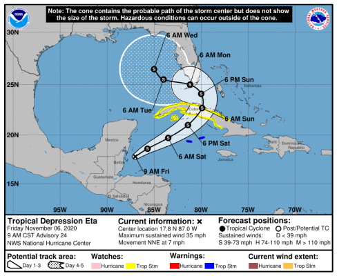
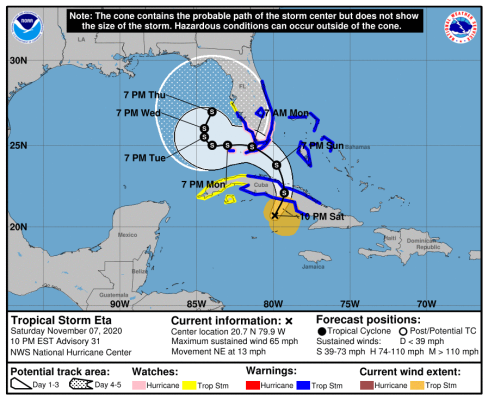
Uh-oh! Although we won’t have much clarity until past the weekend IMO.Getting back to hurricanes in the Gulf, here's the latest NHC track. Hmm!
Uh-oh! Although we won’t have much clarity until past the weekend IMO.
Well it is sort of a bowl geographically that's below sea level for the most part...Maybe that's pulling them in...Has New Orleans turned into some sort of gravity well that sucks all matter into it, starting with all cyclonic storms?

Has New Orleans turned into some sort of gravity well that sucks all matter into it, starting with all cyclonic storms?
Well it is sort of a bowl geographically that's below sea level for the most part...Maybe that's pulling them in...
It's a fading memory these days but I seem to remember when I was a young man (13 or 14 years old) walking down Canal Street and seeing ships going by on the Mississippi that sure seem to be up higher than the surrounding terrain. Maybe it was an optical illusion...
 )
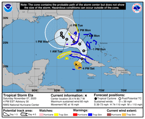
)Hmmmm - storm movement is just going to stall out in the Gulf west of Florida?
I hope they don't get flooding in that part of Florida. I remember Tropical Storm Allison back in 2001. It was a slow mover with heavy rainfall, and caused considerable flooding in Texas primarily but also in Louisiana.
Also notice the (pink) hurricane watches issued over southern Florida! This storm is just one surprise after another.
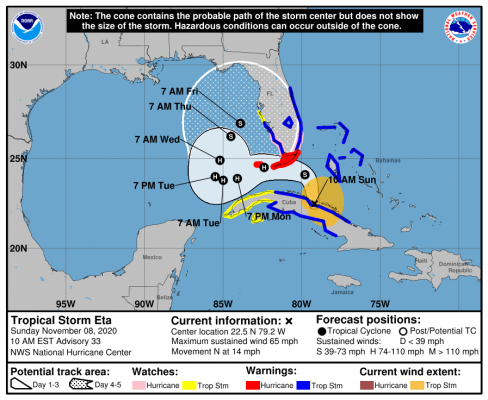
Yeah some of the models have the storm turning back east over Tampa after hitting Florida in the original pass.
Could get interesting.
Take care, Dtail and other Floridians.Yikes!
This one should be called Snake!
Crazy! Forecast track shifting south and hurricane watches now.
Yeah some of the models have the storm turning back east over Tampa after hitting Florida in the original pass.
Could get interesting.
I am about 80 miles north of Tampa, and will be watching closely to see if that turn to the NE happens or not. Some models are now projecting that the storm just stalls out (around tues/wed) some distance out in the Gulf, generally west of Tampa, and then weakens over the next couple days or so before drifting to the north. If that happens, it will probably mean a fair amount of rain for Tampa and points north, but not all that much wind. And hopefully not much storm surge either............that is what I worry about more than anything.