Htown Harry
Thinks s/he gets paid by the post
- Joined
- May 13, 2007
- Messages
- 1,525
love the forecast ht harry. where are you (you mentioned within forecast) btw?
Htown = Houston.
Since inquiring minds want to know, here is some narrative and a few maps that show some of the things we'll be watching for in the greater Houston area.
We live about 50 miles inland, not far from downtown in a neighborhood about 50 feet above sea level and a generous distance away from the nearest creeks (bayous in the local vernacular). No worries for my own safety at this location unless the storm gets to Cat 4 or Cat 5.
The 10pm forecast has Houston's odds up to 80% for TS winds and 25% for hurricane-force winds. Ominously, the forecast track has moved to the north.
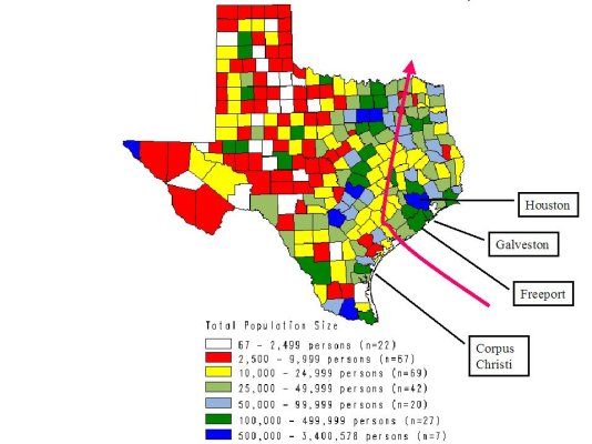
The first map shows the 6 pm forecast track laid over a map that shows Texas population density.
The good news in that map is its forecast track misses Houston, the other Texas metropolitan areas and the largest coastal towns. If the storm takes a path near Matagorda Bay and then hooks right, the most populous area in the storm track is the Bryan-College Station area northwest of Houston.
The bad news is that the Houston-Galveston-Freeport area will likely be on the wet and windy side of the storm, where the higher tides occur.
One worst case scenario, now looking a bit more probable, is for the storm to hook to the north before making landfall, striking somewhere near Freeport as a category 3+. If conditions are exactly right, that would bring a big storm surge into Galveston Bay at high tide and the highest-intensity winds through Houston. This is more or less what happened in the early 1960's with Carla. A much weaker Alicia (Cat 1 or 2) took a similar path in the early 80's, but didn't have the power to create a significant storm surge.
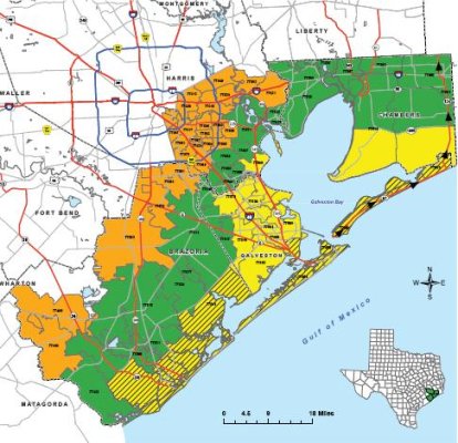
The evacuation planning map shows the areas that can be directly affected by the storm surge or related coastal flooding. From the coast to about 100 miles inland, the generally topography is extremely flat. Typical grades are only a foot or two per mile.
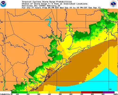
The last map is one to watch. It's a close-up of the NHC's 6pm storm surge prediction map, showing the highest probability of high water is currently somewhere near the mouth of Galveston Bay. The brown represents a 50% chance of 5+ feet tides. The current map shows higher odds. That's cause for concern, as evidenced by evacuations beginning earlier today in the Freeport area and points farther to the south along the coast. Hurricane IKE Storm Surge Probabilities
For Houston proper, winds over 40 mph will start to bring down trees and power lines. Our wet climate along the coast makes us a very green city. I was here for Alicia and I remember entire neighborhood parks coverted to dumping grounds for downed trees. Power outages were pretty widespread.
Which brings me the the real worst-case scenario for the urbanized area - flooding along the bayous made worse by the high tides where the creeks and bayous empty into the bay.
The most wide-spread flooding in a generation occurred in 2001, with TS Allison. That storm stalled over us and dumped an unbelievable amount of water. An inch in an hour is a pretty heavy rain. We had areas that saw a continuous downpour of two to three inches an hour for over half a day. See the effects in a flash movie posted at a link at the lower right corner of this site: Tropical Storm Allison Recovery Project - TSARP
We're watching...closely. When the local emergency management folks make announcements in the morning, I suspect they will order much wider evacuations. By the end of the day tomorrow, I'm fairly certain will be recommending area-wide school and business closures for Friday.
Naturally, the TV weathermen are already breaking out their arsenal of alarming cliches. But folks will start to take real action only when they hear that the high school football games are called off.

Last edited:
")
