You are using an out of date browser. It may not display this or other websites correctly.
You should upgrade or use an alternative browser.
You should upgrade or use an alternative browser.
what did you do today? (2008-2015) (closed)
- Thread starter Khan
- Start date
- Status
- Not open for further replies.
Cassie
Recycles dryer sheets
- Joined
- Jul 3, 2012
- Messages
- 281
NW, stunning photos, thanks for posting. I went to a monthly breakfast @ Denny's with my walking group. Afterwards went to the movies to see Paul Blart 2, not as funny as the 1st...I enjoyed it as it was filmed at Wynn Las Vegas.
aja8888
Moderator Emeritus
Added a yard drain collection point to the lowest part of our yard. I guess the contractor who built the place 15 years ago didn't notice the low point?
Also, the sprinkler system zone valves in the photo are not where I would have put them, and I wouldn't have buried them in the ground! It would be a mess to relocate them so they are staying. At least they won't be totally underwater when it rains and for days afterward. Since it has been raining here quite a bit, the soil is pure mud and I was covered with it afterward.

Also, the sprinkler system zone valves in the photo are not where I would have put them, and I wouldn't have buried them in the ground! It would be a mess to relocate them so they are staying. At least they won't be totally underwater when it rains and for days afterward. Since it has been raining here quite a bit, the soil is pure mud and I was covered with it afterward.
NW-Bound
Give me a museum and I'll fill it. (Picasso) Give me a forum ...
- Joined
- Jul 3, 2008
- Messages
- 35,712
It seems people enjoyed the scenery in Death Valley, so I am posting a couple more photos as a free advertisement for this underappreciated National Park (it was upgraded from a National Monument to the NP status in 1994).
Death Valley has the dubious honor of being the hottest point on earth at 134F (56.7C), or the 2nd, depending on whom you listen to. And it was recorded at Furnace Creek, where our campground was. It also has the record of highest low temperature at 107F (41.7C) at night, and also the highest average temperature of 117.5F (47.5C) averaged over a 24-hr period.
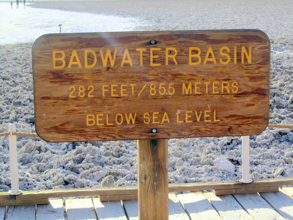
Death Valley also has the lowest point in the US at 282 ft below mean sea level (MSL), called Bad Water (our campground was at a mere -190 ft MSL). The water table at Bad Water was only a few inches below the surface, but it was so laden with salt that the sand was encrusted with salt as seen in the photo.
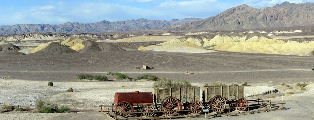
Borax was mined here, and a mule-drawn wagon train was on exhibit at the ruin of Borax Works. I will have a bit more to say about this.
Death Valley has the dubious honor of being the hottest point on earth at 134F (56.7C), or the 2nd, depending on whom you listen to. And it was recorded at Furnace Creek, where our campground was. It also has the record of highest low temperature at 107F (41.7C) at night, and also the highest average temperature of 117.5F (47.5C) averaged over a 24-hr period.
Death Valley also has the lowest point in the US at 282 ft below mean sea level (MSL), called Bad Water (our campground was at a mere -190 ft MSL). The water table at Bad Water was only a few inches below the surface, but it was so laden with salt that the sand was encrusted with salt as seen in the photo.

Borax was mined here, and a mule-drawn wagon train was on exhibit at the ruin of Borax Works. I will have a bit more to say about this.

Last edited:
NW-Bound
Give me a museum and I'll fill it. (Picasso) Give me a forum ...
- Joined
- Jul 3, 2008
- Messages
- 35,712
While Death Valley is below sea level and the lowest point of the US, the photo that I took of the Sierra Nevada Range to the west of Death Valley included Mt. Whitney which is the highest point in the low 48 states at 14,500 ft.
So, climbing out of Death Valley on CA-190 was an ordeal for my motorhome, as it was pulling a car behind it too. They did not post the grade of the road, but it was worse than the road going west from Jackson, Wyoming, that I had driven the motorhome on, and that road was posted at 10% grade. CA-190 was both steeper and a lot longer. Thank goodness, my motorhome never overheated, though it had to climb out in 1st gear, and its speed dropped as low as 19mph.
But, here's what's more impressive. The wagon train I posted a photo of earlier weighed 36 tons when laden with borax, and it was pulled by a team of 20 mules. They covered 165 miles in 10 days! What an abuse of these poor animals!
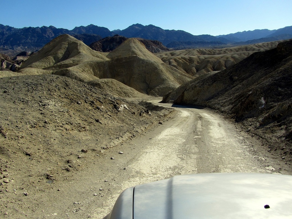
Here are some photos when I made excursions with my towed SUV on roads not suitable for a motorhome.

So, climbing out of Death Valley on CA-190 was an ordeal for my motorhome, as it was pulling a car behind it too. They did not post the grade of the road, but it was worse than the road going west from Jackson, Wyoming, that I had driven the motorhome on, and that road was posted at 10% grade. CA-190 was both steeper and a lot longer. Thank goodness, my motorhome never overheated, though it had to climb out in 1st gear, and its speed dropped as low as 19mph.
But, here's what's more impressive. The wagon train I posted a photo of earlier weighed 36 tons when laden with borax, and it was pulled by a team of 20 mules. They covered 165 miles in 10 days! What an abuse of these poor animals!
Here are some photos when I made excursions with my towed SUV on roads not suitable for a motorhome.


NW-Bound
Give me a museum and I'll fill it. (Picasso) Give me a forum ...
- Joined
- Jul 3, 2008
- Messages
- 35,712
After coming out of Death Valley, I drove north on the eastern flank of the Sierra Nevada Range for a couple of hundred miles. The only way to pass the mountain range to go west is through Tioga Pass, which leads to Yosemite NP. However, this road was still closed. I had driven through this pass in two occasions many years ago, and at 10,000 ft there was still snow and ice on the lakes in June/July!
So, I chose to cross the range on CA-89, which was south of Lake Tahoe. This was a steep road too, and even narrower and more winding! Again, if my motorhome overheated or its transmission failed, I would be in deep doo-doo.
Again, they did not post the grade of CA-89, but my estimate is that it is perhaps as high as 15% in many sections.
But, but, what was scarier was when I came to the intersection of CA-89 and CA-4, and what did I see but a sign posting a grade of 24%!
Thank goodness, I took the other fork, and did not have to subject my motorhome to possible failure. I did not have the chance to take a photo of that road sign, but was able to see that on Google Street View. See the link below.
https://www.google.com/maps/@38.660...ata=!3m4!1e1!3m2!1seaYgaEFlaRE9otjO2FDb-w!2e0
Last edited:
Death Valley also has the lowest point in the US at 282 ft below mean sea level (MSL), called Bad Water
I visited that spot in 2004. I had my pocket Garmin GPS with me, so I walked out to where it read the absolute lowest point and scooped up a handful of salt and sand into a ziplock sandwich bag. So now it's a bit lower than before my visit!
 I still have that little bag on the shelf, along with mementos from other "extreme" points I've visited.
LRDave
Thinks s/he gets paid by the post
Today I got around to a spring cleaning task of cleaning the dust bunnies from the gable end of our great room. What a mess! I have a nice 7 point whitetail buck neck mount at that gable end and it was caked with dust bunnies. I also have my first pair of downhill skis, bear-trap bindings and leather laced ski boots mounted in a "V" with the mount in the middle of the "V" and the boots were caked with dust bunnies as well.
It continually amazes me that the ceiling fan that we have running all winter collects so much dust bunnies since it is moving all the time.... how do the fan blades of a moving fan collect dust?
Anyway, that task is done for a while. Then I made a small pot of refrigerator soup for lunch. Cold, rainy, windy day here... it was actually snowing for about 10 minutes while I was cleaning the mount and it accumulated slightly but is all gone now. Enough!
That's the way airfoils work - there is a suction side and a pressure side. The suction side literally sucks in particles of dust and they land on the blade surface and stay there. There is a buffer zone above the suction side surface where the air is stable even though the fan blade is rotating and providing you a breeze. The dust bunnies have a safe home until relocate them.
")
aja8888
Moderator Emeritus
NW - I don't know anything about your motor home but I would hope that the engine and transmission are equipped with external oil coolers to help with temperature control. That may be a standard upgrade when buying a motor home, but I'm not up on that.
Looks like a nice trip and the weather looks fabulous.
Looks like a nice trip and the weather looks fabulous.
NW-Bound
Give me a museum and I'll fill it. (Picasso) Give me a forum ...
- Joined
- Jul 3, 2008
- Messages
- 35,712
When I changed the coolant recently at 40K miles, I read the specs and found that the standard coolant capacity was 23 quarts. I do not know if the A/T cooler was "supersized" or not. I am just glad that the MH never overheats, and the temperature gauge barely budges from its normal position when the engine gets exercised. In fact, until I changed the coolant, I never had to add any. Son of a gun!
I have to log off now. Until I have something interesting to tell...
Onward Ho!
I have to log off now. Until I have something interesting to tell...
Onward Ho!
Theseus
Recycles dryer sheets
- Joined
- Aug 4, 2013
- Messages
- 484
Called in a theft report to the county sheriff's office. Scoundrels made off with two split rail posts, pulled right out of the ground, and eight rail sections. Before photo was when our dog helped me stain it last summer, after was as I found it this morning when going to get the mail. WT@%^& 
Attachments

pb4uski
Give me a museum and I'll fill it. (Picasso) Give me a forum ...
What a strange thing for someone to steal! I'm guessing less than $100 of materials? Someone must be pretty desperate.
Theseus
Recycles dryer sheets
- Joined
- Aug 4, 2013
- Messages
- 484
Yeah, about $91 for the posts and rails from the big orange box. But I figured might as well throw in a gallon of stain and something for my labor so I claimed it as $300. I'm sure they have an APB out for the perps already - not!
TromboneAl
Give me a museum and I'll fill it. (Picasso) Give me a forum ...
- Joined
- Jun 30, 2006
- Messages
- 12,880
Today I finished turning this

into this

and this

Now I have to split them.
Every year I say "I'm getting too old for this," but this year I got an offer I couldn't refuse. All those logs were delivered to my driveway, free, of course.
I had kicked myself for buying a smaller model of chainsaw (250) partly because it was cheaper, and partly because it was lighter. But a few weeks ago I modified the muffler and carb, and now it really screams.
I'm extra sore from moving those logs around. Good paleo exercise, I guess.
into this
and this
Now I have to split them.
Every year I say "I'm getting too old for this," but this year I got an offer I couldn't refuse. All those logs were delivered to my driveway, free, of course.
I had kicked myself for buying a smaller model of chainsaw (250) partly because it was cheaper, and partly because it was lighter. But a few weeks ago I modified the muffler and carb, and now it really screams.
I'm extra sore from moving those logs around. Good paleo exercise, I guess.
W2R
Moderator Emeritus
Getting ready for the summer heat! Since my AC is already not able to keep up with the heat, I got my HVAC guy to do a "spring checkup" this morning. Turns out I need a new evaporator coil but at $1,888 installed, this is not going to be a budget breaker. He'll install that on Tuesday.
Meanwhile, I decided that my very heavy loveseat in the den was a little too close to the AC filter grate, so I got Frank to help me move it away from that grate and into my home gym room. This turned out like a Dagwood and Blondie cartoon, as that simple task ballooned and we ended up having to move nearly every piece of furniture in both rooms.
And finally we went to Ace Hardware so I could buy another crate of AC filters, so I'm all set for summer. Somehow in the middle of all this we managed to make it to the gym and I completely over-did it, doing a new cardio workout. I'm bushed!
Tonight we are going out for a steak dinner. I think we earned it.
Last edited:
ls99
Give me a museum and I'll fill it. (Picasso) Give me a forum ...
- Joined
- May 2, 2008
- Messages
- 6,513
Hung out at the mancave, watched the snow fall all day, nursing some coffee, none of it stuck on driveway or roads. Took a break to go figure skating in Johnstown, then back to the cave for more snow gazing. On the way home at the top of one of the mountains there was about a half inch of snow, heavy fog. Within a mile of the house the sun was out and no sign of precip.
Looking4Ward
Full time employment: Posting here.
what did you do today?
Our downstairs powder room has had a wet spot on the wall to the left of the pedestal sink for several years. We attributed it to our young son splashing water from the sink while washing his hands. But he stopped using that room several weeks ago yet the spot on the wall was still moist to the touch.
So today I decided to cut out a small section of the drywall to see what was going on. Blackened framing behind it, so I keep cutting and keep cutting until I found a water pipe about five feet from the floor leaking at the elbow.
I'll end up removing the pedestal sink and about 15sf of drywall, resolder the elbow, remediate the mold, put up new drywall, texture and paint. Will probably spend about $100 on supplies but figure I'm saving a thousand or more.
That's what I did today.
Sent from my iPad using Early Retirement Forum
Bestwifeever
Moderator Emeritus
- Joined
- Sep 17, 2007
- Messages
- 17,774
We went to see the Second Best Exotic Marigold Hotel at the cheap seats theater. It got hohum reviews but we enjoyed it--the story is on the light side, but that cast (Judith Dench, Maggie Smith, Bill Nighy, etc.) is most enjoyable and Richard Gere was a fun addition.
John Galt III
Thinks s/he gets paid by the post
- Joined
- Oct 19, 2008
- Messages
- 2,803
After several days of deciding, went ahead and chopped off a tree(?) root that was approaching the corner of my house and a downspout. Consensus on internet was that the root may end up sucking too much water away from the foundation, allowing earth to settle, causing problems.
OP
OP
Khan
Gone but not forgotten
- Joined
- Aug 23, 2006
- Messages
- 6,924
Took a 3 mile walk this morning, broke the 20 minute mile, seriously humid.
Need a combination sunblock/bug repellent.
Need a combination sunblock/bug repellent.
Yesterday was busier than I prefer now that I'm retired. Dropped the kids off at school at 7:20 (their school has "early bells"). Drove to my Italian class. Found out we have a test on Monday, a formal presentation due, a journal entry due (14 sentances using future tense)... Right after class I scurried across campus and to the high school next door to register my eldest for high school next year. Space is limited in the International Baccalaureate school within a school - so I wanted to get that done as a priority. From there I scurried back across the college campus to where I'd parked. I had just enough time to make an appointment I had with our insurance agent. It was an informative meeting, although he did broach "retirement plans" he offers, but I shut that down.
Came home, had lunch, made pie crust and got that in the fridge... then headed out to pick the kids up. Upon return coerced kids into doing all homework and piano practice while I made pumpkin pie (from frozen puree I'd thawed out - last of the pumpkins we grew last fall). Took older son to batting practice after dinner.
Today is mellower. Started with dropping the kids at the bus stop and taking the dog down to the beach. It's been low-low-low tide so my walks are extended because I can head further south and north. MyTracks says I clocked over 3 miles today. Now I'm trying to get motivated to study for Monday's test.
harley
Give me a museum and I'll fill it. (Picasso) Give me a forum ...
Took a 3 mile walk this morning, broke the 20 minute mile, seriously humid.
Need a combination sunblock/bug repellent.
You've got that right. In another thread I was saying that the bugs in FL weren't as bad as everybody said. But I was outside working on an electric outlet on the side of the house, and I was being drained by mosquitos at a rate of about 1 pint/hour. Obviously I didn't know what I was talking about. And I don't think the high temp has been much below 90 since late March.
Get a big old floppy hat. DW has a few.
aja8888
Moderator Emeritus
Results of annual physical: Good shape, good lungs and heart (previous long distance runner continuing benefits), but need to lose 25 pounds. Well, thanks Doc!
Started a low carb eating routine. Got a bunch of high protein/low carb shakes from Sam's Club for starters. Goodby sweets.
Started a low carb eating routine. Got a bunch of high protein/low carb shakes from Sam's Club for starters. Goodby sweets.
Moemg
Gone but not forgotten
Getting ready for the summer heat! Since my AC is already not able to keep up with the heat, I got my HVAC guy to do a "spring checkup" this morning. Turns out I need a new evaporator coil but at $1,888 installed, this is not going to be a budget breaker. He'll install that on Tuesday.
/QUOTE]
That price seems high . I had mine replaced last year and it was $1800 but that included a crane $700 since my house is elevated .
W2R
Moderator Emeritus
Did I mention that going out for a romantic steak dinner with my honey was so much fun last night? We had such a wonderful time. I am so lucky to have him in my life.
- Status
- Not open for further replies.
Similar threads
- Replies
- 126
- Views
- 5K