Smart phone in lieu of dedicated GPS unit?

I've been smart phone GPS'ing exclusively for the last 4 years or so (since I got my first smart phone). Google Maps is my go to in the US where I have (free) cell service. Overseas, I use google maps offline for the mapping and location part. The GPS nav won't work without cell service I don't think.

A decent GPS navigation without cell data is the maps.me app. I didn't like it as much as google maps so rarely used it. You download a map data pack (for free) for whatever state(s) or country(ies) you are visiting.

If you need a cheap cell phone and free cell service, freedompop is pretty good. I saw they had a $40 smart phone that includes free cell service (their deals come and go of course). Better deal than a GPS IMHO, and the 500 mb/month of free data should be plenty for even the hardiest GPS users. And you also have a phone, 2 way comm device, email, texts, camera, etc in the same device.
 
Yes! I've been using the smartphone exclusively. Typically I use Google Maps. However, there is also the free for Android "Here Maps" which lets you download maps for offline use. It is made by Nokia and equally as good as Google Maps for Navigation. Zero need for the standalone GPS.

Good to know about the Android "Here Maps". I've been using a cheap no-service windows phone as a stand-by nav-unit. Works great.

Would be nice to get ability to add way-points to a route though. Probably possible on some dedicated nav units; not seen it in a phone.
 
Co Pilot claims to have waypoint ability, but it is android only.
 
Hey, thanks to earlier posters who mentioned some free maps for Android.

We have a couple of old iPhones, but also an 8" Android tablet that my wife uses to watch youtube videos. I have downloaded a couple of apps for it, such as an OBD display, and they work great. I have meant to get a map app for it, but keep forgetting. This tablet has a built-in GPS. Its screen size will beat any smartphone.
 
Right but for most passenger cars, you can't have too big a screen on the dashboard because it would obscure the windshield.
 
I've used my nexus 4 for most of my road GPS needs. It just died and I went with a more modest phone, but expect it will do well for on the road GPS needs.

For backwoods hiking...no cell towers, electricity, etc... I think I'm going to pick up a dedicated GPS where I can change batteries instead of bring a solar cell and try to charge a transfer battery and recharge the phone at night. Plus this will work internationally without extending my cell plan.
 
Right but for most passenger cars, you can't have too big a screen on the dashboard because it would obscure the windshield.

The iPhone 6 Plus screen is already 5.5". When Apple comes out with iPhone 9, it will finally catch up to this 8" tablet. :cool:

Come to think of it, the tablet will be perfect for my wife to use while being my navigator in the car, except that the netbook is still better for the motorhome.
 
Last edited:
For backwoods hiking...no cell towers, electricity, etc... I think I'm going to pick up a dedicated GPS where I can change batteries instead of bring a solar cell and try to charge a transfer battery and recharge the phone at night. Plus this will work internationally without extending my cell plan.

I've used a couple of car GPS's for hiking, and have had a lot of problems with no satellite access due to tree cover and being on the downhill side of the mountain. I have been thinking about getting dedicated backpacker's GPS and seeing how that works. Of course it's been a few years since I tried them. Maybe they are better at dealing with the tree cover now.
 
I'm not a big fan of either. Recently, I had to go from western Canada to Bozeman Montana. I printed googlemaps directions, looked at my Magellan GPS instructions and consulted a map. The results:
1) googlemaps via PC. took a bit of a roundabout route, estimated 11 hours
2) GPS. took a different route, no time estimate
3) map, then put my chosen route into GPS. Got there in ~8 hours.

Option 3 lets you calculate the best route and then the GPS tells you where to turn. It wasn't perfect, wanted to go through some towns (like Malta Montana) rather than use a shorter route around them
 
I use the Garmin for road trips, because 1) I'm concerned about needing a cell connection for the smartphone GPS, although the 'Here' maps on my windows phone can be downloaded on the phone 2) I use the phone for listening to podcasts, etc while on a road trip, and the multi-tasking on one device is too much for me (not the phone) to handle. 3) Also the Garmin maps are better than any of the smartphone maps I've tried. and the Garmin routing is really good. I update the Garmin maps, never update the built in GPS maps in the car, because they want too much money.

However, for my daily commute, I use Waze on my smartphone and never the Garmin. The real time traffic events are great. But Waze is well known for its poor routing, so I only use it on my commute that I already know all the routes for.
 
I've used a couple of car GPS's for hiking, and have had a lot of problems with no satellite access due to tree cover and being on the downhill side of the mountain. I have been thinking about getting dedicated backpacker's GPS and seeing how that works. Of course it's been a few years since I tried them. Maybe they are better at dealing with the tree cover now.
For hiking I usually use the GPS as a safety valve. I let it track where I've been. If I get lost... I can use it to backtrack back out. When I'm hiking... it is partially to get away from the the tech.

I'm not a big fan of either. Recently, I had to go from western Canada to Bozeman Montana. I printed googlemaps directions, looked at my Magellan GPS instructions and consulted a map. The results:
1) googlemaps via PC. took a bit of a roundabout route, estimated 11 hours
2) GPS. took a different route, no time estimate
3) map, then put my chosen route into GPS. Got there in ~8 hours.

Option 3 lets you calculate the best route and then the GPS tells you where to turn. It wasn't perfect, wanted to go through some towns (like Malta Montana) rather than use a shorter route around them
I often use google maps... but when setting up the route I drag the route through places I want to go. Thus no need to "plug points back into a GPS". This still allows for rerouting for traffic issues by the silly phone.
However, quite often I just use maps. There have been studies that indicate that relying GPS's degrades some cognitive abilities. Sometimes it is good to just work through it manually. I remember my father in law using a GPS and verbally arguing with it as he drove. He knew the route he wanted to use and knew it well... in that case... why use a GPS? :blush:
 
I still use my Garmin Nuvi with free lifetime map updates, as I tend to use my phone more for listening to music/podcasts when driving and as was mentioned above don't want to be distracted multi-tasking on a single device. I have a CD/DVD slot mount (why listen to CD/DVD when you have a phone or MP3 player) that is much more sturdy than windshield mounts. I bring the Garmin when traveling for business/vacation to avoid the rental car GPS fees.

I do use the Waze app and like but - and maybe it is my phone - it seems to drain the phone battery even while plugged in. I tend to use it for shorter local trips during rush hour as it does well looking at traffic and finding the best route, identifying road hazards/issues, etc. Maybe when I get a bigger, sturdier, more battery-efficient smartphone I'll use it more and eventually replace the Garmin. But for now I have plenty of storage room and outlets in my car dashboard and armrest so having both is no big deal.
 
I'm happy using my old but trusty Garmin Nuvi 260 with lifetime map updates. My big fear is the GPS will konk out and I'd need to get one with all the bells and whistles but adds more complication than needed.

For those who use smartphones, do you a phone mount for viewing? Or do you just hold the phone by your side?

I use the bean bag mount for my GPS.

On a side note, I wonder if you got pulled over while using your smartphone as a GPS, will the cop still write you a ticket in some states for using your phone while driving? I watched on the morning news where cops where issuing tickets to folks on their phone screens. Then this one guy, who was obviously distracted, got pulled over. But he was staring and entering stuff on his GPS. No ticket written since GPS is legal.
 
On a side note, I wonder if you got pulled over while using your smartphone as a GPS, will the cop still write you a ticket in some states for using your phone while driving? I watched on the morning news where cops where issuing tickets to folks on their phone screens. Then this one guy, who was obviously distracted, got pulled over. But he was staring and entering stuff on his GPS. No ticket written since GPS is legal.

My defense is I'm using the GPS.

I use GPS on my phone while driving, especially if there's a lot of traffic. Real time route selection based on actual traffic conditions means I might cut a minute or three off a drive during rush hour.

Oh, and how do people drive in rush hour every day and remain sane? WTF.
 
... I do use the Waze app and like but - and maybe it is my phone - it seems to drain the phone battery even while plugged in. ...

Verify that your phone sees the car charger/power-supply as an "AC Charger" or "Wall Charger" or "Fast Charger" or something like that.

Apple uses a different method from Android to determine if the charger/supply provides high current. Apple has resistors on the data lines to ID the different types, Android went to the USB consortium and had a standard set for this, shorting the data lines IDs the charger as a high current device.

So it depends on the charger/supply. But with android, you can take a cable, cut the two data lines somewhere between the ends, and short the two data lines on the phone connector side. Mark the cable as "Charge Only", and the phone will pull as much current as it can from any power source you plug it into. Just make sure the power supply is beefy enough to supply a high current.

Here's a guide (though I would solder the wires, but twisting them probably works fine):

https://www.ibm.com/developerworks/...ssue_solved_hack_your_usb_cable_today?lang=en

-ERD50
 
I only use my iPhone and the Waze app when driving. Waze is far superior to Google maps and the native Apple map app. When I'm in town I turn the Waze app on, plug the phone into the data/charger cable in the center console storage, and just listen to the voice prompts. If I'm away from home and not familiar with the area I will pull it out of the storage compartment so I can look at the screen more often.

I think one's comfort with technology and navigating plays a big part in what you use. One of my sons is a Luddite and has the navigation skills of a rock, he uses a Garmin GPS and constantly gets lost. It is not unusual for him to miss turns and turn a 30 minute drive into an hour or more. I've worked with the kid for years on this and I've come to accept that navigating is a non-starter for him. A couple of times he's found himself in a shady area by accident. I'm very comfortable with all this, but I learned navigating as a boy scout, and honed those skills with a lifetime of being in the military and law enforcement - navigating is like second nature for me. I'm also very comfortable with technology so using the phone and apps like Waze seems simple for me.
 
I do use the Waze app and like but - and maybe it is my phone - it seems to drain the phone battery even while plugged in. I tend to use it for shorter local trips during rush hour as it does well looking at traffic and finding the best route, identifying road hazards/issues, etc. Maybe when I get a bigger, sturdier, more battery-efficient smartphone I'll use it more and eventually replace the Garmin. But for now I have plenty of storage room and outlets in my car dashboard and armrest so having both is no big deal.

Jolly, one tip (for the iphone, don't know about other phones), I like to turn off Waze's access to my location when I'm not using it, since it does use up battery life when not on. It is kindof a pain, but just go to settings, privacy, and location service, and switch Waze to never from always. It irritates me that there is not an option for while using, like on some other apps, but I guess that is why they are able to report real time traffic, based on the movement of other silent Wazers.
 
My defense is I'm using the GPS.

I use GPS on my phone while driving, especially if there's a lot of traffic. Real time route selection based on actual traffic conditions means I might cut a minute or three off a drive during rush hour.

Oh, and how do people drive in rush hour every day and remain sane? WTF.

Looks like the phone as GPS defense won't hold up in California.

A California appellate court has ruled that using the GPS or mapping functionality on a phone is a moving violation, on par with driving while texting. Steven Sriggs, the defendant in the case, was pulled over for using a phone while operating a motor vehicle, but he wasn't texting or making a call - he was looking at a map.

Calif. Court Upholds Ticket for Phone GPS Use While Driving - ABC News

When I was w*rked, I remember myself and co-w*rkers screaming bloody murder when there was any rumor about being transfered where we couldn't travel by commuter train.
 
...I remember my father in law using a GPS and verbally arguing with it as he drove. He knew the route he wanted to use and knew it well... in that case... why use a GPS? :blush:
One can use a GPS without the routing simply to see where he is currently on the map. But of course, if you are traveling on a well-worn path, you already know where you are, let alone asking it to set up a route then argue with it.

As described earlier, I have used cached maps on an iPhone, and navigate just by seeing where I am on the map relative to the destination. It is because without a cell data link, all other functions are lost. I will see if other map programs are better in stand-alone mode, if I can pry the Android tablet from my wife.

The MS Street-n-Trip for the PC fits on a 4 GB DVD and has all of the US and Canada streets. There is no reason one cannot fit the same road database into a tablet with 64 GB of flash memory, although downloading the data will take a long time even if it is permitted.
 
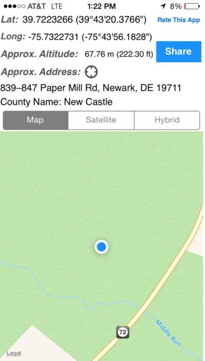
I've been using the iPhone app WhereAmIAt? for hiking, etc. It gives you Lat, Long and a small map. While I was exploring the Mason Dixon line, i navigated to a MD monument with published survey grade coordinates. My WhereAmIAt? coordinates were within 35' of the published coordinates. Surprising accuracy (or luck) from a cell phone GPS under full tree canopy.

Its a cool GPS app. perfect for when someone calls or texts you wanting to know where you are at - Just send them a screenshot of your map and coordinates.
 

Attachments

  • Screen Shot 2015-08-07 at 10.31.44 AM.png
    Screen Shot 2015-08-07 at 10.31.44 AM.png
    711.4 KB · Views: 9
Last edited:
Thanks for all the great replies.

After thinking about it, I'm now planning to get a new Garmin GPS unit with lifetime map updates. As for shopping for one, it's almost overwhelming how many incremental variations of these things there are.

omni
 
My defense is I'm using the GPS.

I use GPS on my phone while driving, especially if there's a lot of traffic. Real time route selection based on actual traffic conditions means I might cut a minute or three off a drive during rush hour.

Oh, and how do people drive in rush hour every day and remain sane? WTF.
below from
GPS devices are covered under distracted-driving laws. Whether you’re in compliance depends on how you use them, even how you install them. And failing to follow the rules is not only expensive in terms of tickets, points against your license, and higher insurance premiums, it can also be dangerous.
I thought I'd search since I did not know the answer.... so it looks like my phone is a GPS won't fly many places since GPS are included in DD Laws. Keeping your hands on the wheel have a better chance.
 
I thought I'd search since I did not know the answer.... so it looks like my phone is a GPS won't fly many places since GPS are included in DD Laws. Keeping your hands on the wheel have a better chance.

Guess I'll go back to staring at paper maps to avoid any tickets... :D
 
Is it legal in your state to mount the GPS on the windshield?

50% of states have laws against windshield mounting. It's legal in my state but not in the neighboring state (20 miles away).

I'm not sure how legal it is, but I mount mine in front of the tachometer. I can still see the speedometer, gas gauge, etc. but just not the tach. I find it very easy to see and convenient.
 
Back
Top Bottom