Storms Marco & Laura Heading for the Gulf States

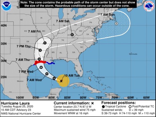
Laura is still projected to strengthen into a hurricane and land as a category 2.

The forecasts and projections for Laura have been evolving lately. I hate to say this, but some models now project it could make landfall as a Cat 4 hurricane. Storm track has consistently been edging to the west also. Houston and surrounding areas are definitely still at risk. For anyone living in that general area (west LA to east TX), please make sure you monitor conditions closely over the next day or two. Stay safe!
 
Hurricane track forecasts have improved. Five-day forecasts are now at least as good as three-day forecasts used to be 10 or 15 years ago.

Intensity forecasts have not improved much over the same time span.
 
Hurricane track forecasts have improved. Five-day forecasts are now at least as good as three-day forecasts used to be 10 or 15 years ago.

I think that is generally true, but these latest two Gulf storms have been defying the odds and driving the forecasters crazy. Three days ago, Laura was projected to threaten the Florida Keys and Florida Gulf Coast. As of this evening, they are talking about it possibly making landfall as far west as Galveston, Texas or possibly even just west of there. The usually reliable global models (Euro and GFS) have been bouncing all over the place in recent days, changing their track forecasts. So, you really have to stay alert, as things can change pretty quickly.
 
Marco has made landfall at the mouth of the Mississippi, in such a weakened state that we can now stop thinking of that nothing burger. :D

We'll see where Laura goes. Hoping for the best for those living where ever she comes ashore.
 
Marco dissipated, but they were loath to admit it for reasons that tend to controversy, so I'll stop there.

Meanwhile, the fast, dissipating movement of Marco opens the door for Laura because she'll have no disruption.

Don't take your eye off of this, TEXAS. Laura has had a bad habit of trending left. Be careful. And with a wide open, warm Gulf, she could strengthen significantly. The current Euro model puts Galveston/Houston in danger. Be on the lookout and watch carefully.
 
People seem endlessly surprised that they watch entertainment shows and they have some fear/entertainment agenda?

If you are watching something that plays on your emotions, to me that isn’t news. It gets tiring when everything turns into some conspiracy about ‘the media is trying to convince me’. There are plenty of fact based sources - nobody is forcing you to watch ‘StormFearWatch 24/7 we will broadcast under your covers’
Not everyone gets their weather news from broadcast TV or cable.

Looking at the NOAA predictions you could see what was happening. Marco did become a hurricane for a while, then it fortunately petered out. They had predicted it would drop to a tropical storm before making landfall. And as updates came in you could see it was dropping fast. That was good news. But who would know in advance it would peter out so quickly? Maybe someone knows something I don't.

Both storms had wildly varying predictions, and as a consequence the predicted tracks moved around quite a bit as they got updated over time. This sometimes happens when models disagree. In the meantime they provide the best information they can so coastal areas can prepare in advance.
 
W2R, yes Bob is my go to guy. Having lived in southeast LA all of my life I've learned time and time again that hurricanes are unpredictable until they get into the central Gulf. And with the 2 storms Laura was an unknown until Marco was out of the picture due to Marco's effects on the steering currents. Now that M. is almost out of the picture we can get a better idea of Laura as she moves into the central Gulf. Prayers help.
 
We think one is better safe than sorry, err on the side that will help the citizens the most.

I am all for that. I would rather know the possible than the best, at least when it comes to storms. One would not want to be caught drinking a cocktail by the pool in one's home, in NOL or other coastal area when a cat 3 makes landfall.
 
Laura reminds me a lot of IKE in 2008. Even the past and projected path is similar. Ike hit Houston as a Cat2 and the eye passed within about ~10 miles of my primary house. Over 3 million in the greater Houston area lost electrical power initially and I can remember seeing entire areas (sub-divisions) without power for weeks. Getting food and gasoline was difficult for about a week.

This ones "sounds" like it could be worse (stronger). I hope not...
 
Last edited:
Don't take your eye off of this, TEXAS. Laura has had a bad habit of trending left. Be careful. And with a wide open, warm Gulf, she could strengthen significantly. The current Euro model puts Galveston/Houston in danger. Be on the lookout and watch carefully.


Most of the models are still trending toward a landfall further west as of this morning, into Texas. The National Hurricane Center has hinted that they may move their official guidance (the "cone") slightly to the west on their 10 am update. Places like Port Arthur, Galveston, Freeport and surrounding areas (including Houston) should take this thing very, very seriously. Already predicted to be a major hurricane (Cat 3) and could become even stronger than that before landfall. I believe mandatory evacuation orders have been ordered now for several coastal communities, including Galveston.
 
Laura reminds me a lot of IKE in 2008. Even the past and projected path is similar. Ike hit Houston as a Cat2 and the eye passed within about ~10 miles of my primary house. Over 3 million in the greater Houston area lost electrical power initially and I can remember seeing entire areas (sub-divisions) without power for weeks. Getting food and gasoline was difficult for about a week.

This ones "sounds" like it could be worse (stronger). I hope not...


Yeah, I follow a lot of tropical storm forums, and Ike is indeed the one they are comparing this to - only some are saying Laura could be even stronger. I pray that does not happen, but right now it looks very ominous.
 
How far inland do the Gulf of Mexico hurricanes have their most damaging impact?
 
Depends on the storms landfall strength and forward speed... I now have a house ~150 miles north of Houston and I've seen a ~110 mph storm hit Houston and it was down to about 30 to 40mph gust when it got here. Lot's of rain but minimal wind and no physical damage here.
 
Last edited:
How far inland do the Gulf of Mexico hurricanes have their most damaging impact?
My dads place in central GA, well inland from any coast, was recently crossed by two hurricanes. 2017 Hurricane Irma, which made landfall in the Florida Keys and travelled all the way up the west Florida coast into GA, was still at tropical storm force when it hit the farm, and downed several large trees as well as power out for almost a week. 2018 Hurricane Michael made landfall near Panama City, and roared into southwest GA, still a major hurricane. It was still barely a hurricane when it crossed the farm - very strong winds. A few more trees down, and power out again for almost a week. I remember looking at the statewide power outages at the time and the entire state had widespread power outages, including Atlanta another 100 miles north. DB had several days without power.

Michael was a huge cat 5 hurricane, still a major hurricane when it moved into GA. You can see its massive size compared to the states when overland here. https://www.weather.gov/ffc/2018_hurricane_michael
 
Last edited:
How far inland do the Gulf of Mexico hurricanes have their most damaging impact?
In most cases it starts breaking up over land fairly quickly, but Hurricane Camille was absolutely devastating in central Virginia in 1969. The winds weren't bad but torrential rains caused massive mudslides and flooding. Something like 135 dead in Nelson County, about 1% of the population.
https://www.encyclopediavirginia.org/Hurricane_Camille_August_1969#start_entry

and some pics
https://newsadvance.com/news/local/...n_0630ed20-474c-11e5-a0d0-0bcb843378a8.html#1
 
Hurricane Laura's predicted path keeps inching westward and local hurricane gurus are saying it might end up making landfall at Galveston or Houston as a category 3 or higher. :( So sad to hear this. Stay safe, everyone, and if your local authorities recommend evacuation, do it ASAP to beat the crowds.

We are pretty far out of the cone, and we are supposed to get nothing more from Hurricane Laura than perhaps a little rain and gusty breezes. Right now, it's raining off and on but no wind at the moment.
 

Attachments

  • Capture.JPG
    Capture.JPG
    135.6 KB · Views: 32
Trying to have a significant evacuation from Houston is a nightmare in the best case.... We tried it once (during Rita) and gave up after about 8 hours and only moving a few miles on the freeways... Houston has only grown (a lot) since then and I'm not aware of anything that has been done that would help with the evacuations. In this case with Laura and with the current projected track, you can really only evacuate in few directions, North, Northwest, West and "maybe" Southwest... And if you go North, the storm may follow you a long way. The problem with a significant evacuation from a city the size of Houston is time (or not enough notice to go).... It might be able to be done given 3 to 4 days advanced notice and some coordination... Maybe.... It's now only 36 to 40 hours until Laura makes landfall at it's current forward speed. It's getting to late for many if an evacuation was called for.

If folks would follow the evacuation zones "it may help some", but I've never seen that work very well.
 
Last edited:
And if you go North, the storm may follow you a long ways.
In 1996, we had some friends who evacuated from the coast to Raleigh. Their coastal community suffered only minor damage, being that it was a "left side" hit.

However, they lost their car to a flood in Raleigh, and then suffered with the rest of us days of blocked roads and power outages as they tried to find a way back.
And good luck getting gas or food or finding a rest stop... Getting out of town or coming back.

The only good thing I can see, is there are probably 10's of thousands of hotel rooms available in places like San Antonino, Austin, Collage Station, Waco, etc...
 
Last edited:
How far inland do the Gulf of Mexico hurricanes have their most damaging impact?

You are roughly 175 miles from the coast and should not have to worry about wind damage by the time a storm could reach you. However, severe flooding is a possibility should the remnants of a hurricane park to your southwest for an extended time period. Rainfall of 18 or more inches from such an event is possible.
 
How far inland do the Gulf of Mexico hurricanes have their most damaging impact?

Hurricane Irma (Sept. 2017) weakened to a low Cat-1 by the time it reached the Sarasota area but still caused a mess. I'm not interested in living through anything much stronger. :nonono:
 
Trying to have a significant evacuation from Houston is a nightmare in the best case.... We tried it once (during Rita) and gave up after about 8 hours and only moving a few miles on the freeways... Houston has only grown (a lot) since then and I'm not aware of anything that has been done that would help with the evacuations. In this case with Laura and with the current projected track, you can really only evacuate in few directions, North, Northwest, West and "maybe" Southwest... And if you go North, the storm may follow you a long way. The problem with a significant evacuation from a city the size of Houston is time (or not enough notice to go).... It might be able to be done given 3 to 4 days advanced notice and some coordination... Maybe.... It's now only 36 to 40 hours until Laura makes landfall at it's current forward speed. It's getting to late for many if an evacuation was called for.

If folks would follow the evacuation zones "it may help some", but I've never seen that work very well.

Don't they turn all the Interstates into one-way-out? That would double the lanes dedicated to a quick exit.

Best luck to all. Here in the Islands, we just dodged a bullet. It would have been my first hurricane and it was scary. There is NO way out, either! Best we could do would be to walk up the valley close by to avoid water. I'm sure it would be blocked with cars, so it's not a good choice. We have been told our Condo SHOULD survive a Cat 1, but it's never actually been tried.

Funny what you get used to. One year on the mainland we had a tornado go through our front yard (actually a corn field) and the next year one went through our back yard (left us enough downed trees to supply the stove for years to come.) We just sort of took it all in stride. Interesting to watch a local news helicopter flying around your back yard to see all the damage!

YMMV
 
Don't they turn all the Interstates into one-way-out? That would double the lanes dedicated to a quick exit.

I know they had (have) plans to do that but I think they are very reluctant to use it (again) due to the disaster it caused when it was used back in 2005 for Rita... Now they are trying (again) to evacuate by zones before even considering activating the countraflow plan.... The red text below is a recent quote from the local news on this topic.

The goal is to avoid a scenario like the mass evacuation and chaos ahead of Hurricane Rita in 2005. Millions of people, most outside of evacuation zones, hit the roads, and wound up stuck in standstill traffic for hours.
Ultimately, the mass exodous proved more deadly than the storm itself.


EDIT: I think there were over 100 deaths attributed to this gridlock condition. (It was really hot outside at that time too)

I was in that mass evacuation back in 2005... I think some of the biggest problems are that it takes many hours to reverse the inbound lanes to outbound and then divert half of the traffic. Then at some point they have to merge it back and that creates a tremendous bottle neck and the traffic just stops.


Last edited:
Back
Top Bottom