Poll: Google, Tom-Tom, Apple, Waze?

Which GPS map do you prefer?

  • Google

    Votes: 69 58.0%
  • Apple

    Votes: 17 14.3%
  • Waze

    Votes: 29 24.4%
  • Tom-Tom

    Votes: 2 1.7%
  • Garmin

    Votes: 12 10.1%
  • Paper

    Votes: 4 3.4%
  • Wife

    Votes: 4 3.4%

  • Total voters
    119
  • Poll closed .
FWIW - nav systems are based on a georeferenced line file and associated database. Each line segment is a section of roadway centerline linked to a database record that includes begin address left, end address left, begin address right, end address right, street name, speed limit, city, state, county, and fields of other attributes.

So when a nav system user enters an address to find, the system searches its database to find the matching city, state, street name, etc. there might not be a match between user entered street number and database info. Instead the system finds a database record where the user entered street number falls within the address ranges listed in the database record.

The nav system determines the approximate location of the requested street number as a proration between the beginning and ending line segment addresses.

Say that the user requests 110 Main Street. The system finds a database record with beginaddressleft of 100 and endaddressleft of 200. The system then determines that 110 Main Street is 1/10 of the distance along the line segment 100-200 as measured from beginaddressleft of 100.

As to how it computes directions. - Since the map and line work is georeferenced (drawn to scale in lat/ long coordinates), the system determines the approximate latitude and longitude of the requested address based on the prorated distance along the line segment.

The system knows the users position by gps. So based upon user position and requested position, and speed limits and geometry of the roadway network, it computes the quickest route to get you where you want to go.
 
What do you know, I found again the frame in Streetview at the end of the Demspter road in Inuvik, Alaska, where the two Google cars did a U-turn, and one car captured the other car in its taken photos.

How cool is the photo? And the luck that I found that again after a few years. I was looking around for my trip planning back a few years ago. This Google photo was dated 2009.

https://goo.gl/maps/BSA21C6NkXRKqCsBA
 
FWIW - nav systems are based on a georeferenced line file and associated database. Each line segment is a section of roadway centerline linked to a database record that includes begin address left, end address left, begin address right, end address right, street name, speed limit, city, state, county, and fields of other attributes...

My startup company worked with a set of publicly available files called TIGER data from the US Census Bureau. We needed GIS data for our work of planning telecommunication networks. We used street and road coordinates, but not addresses.

I was not involved in the effort to write the software to compile and translate the TIGER file records into our own inhouse format, so do not know all the details.
 
^ we used the Tiger files also. We entered new line work of street segments of new subdivisions being built for the county 911 office. 911 couldn’t wait for the US govt to update the file. They needed it as soon as the street was built.
 
My favorite Google Streetview photo is this one of DW and I standing on a corner in Moab, UT. :)

https://www.google.com/maps/@38.574...4!1stm1_ys76ij6LYZVPb26lqQ!2e0!7i13312!8i6656

Too bad Google software automatically blurs people's faces (and also other things like car license plates).

The above image is dated 2012.

I once drove behind a Google camera car not too far from my home. Will not bother to go look for the snapshots, as they already re-image my neighborhood. For unknown reasons, my area is updated quite often, perhaps every 2 years. It's a developed area of 35 years old.

PS. I also saw Google Waymo autonomous cars in my neighborhood quite often. What are they doing, driving around these quiet residential suburban streets? Perhaps we are part of their test area, and they keep retracing a particular route to test out some problems.
 
Last edited:
^ we used the Tiger files also. We entered new line work of street segments of new subdivisions being built for the county 911 office. 911 couldn’t wait for the US govt to update the file. They needed it as soon as the street was built.

GIS data is a fascinating field. We take a lot of info for granted, until I could not find a couple of European Airbnbs on Google. When we got there, and were led to the apartment by the host, still could not see how anyone would be able to find these addresses by themselves without asking around.

If you look at high-density population centers in Asia, you would wonder how people could find each other.
 
Too bad Google software automatically blurs people's faces (and also other things like car license plates).

The above image is dated 2012.

I once drove behind a Google camera car not too far from my home. Will not bother to go look for the snapshots, as they already re-image my neighborhood. For unknown reasons, my area is updated quite often, perhaps every 2 years. It's a developed area of 35 years old.
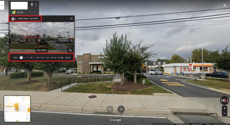
Did you know that Google allows you to look back at older Street View images in some areas? IF you see the clock with the arrow around it as in the image below, you can click the drop down arrow to get the box below it. The lower red box shows dots for every earlier street view that is available. I'm not sure what their criteria is, but I am pretty sure that it's not available for all areas that have been rescanned.

(And if you did know, I'll bet someone else here will find it fun to play with! :LOL:)
 

Attachments

  • Screenshot 2020-12-04 23.05.03.jpg
    Screenshot 2020-12-04 23.05.03.jpg
    414.7 KB · Views: 16
GIS data is a fascinating field. We take a lot of info for granted, until I could not find a couple of European Airbnbs on Google. When we got there, and were led to the apartment by the host, still could not see how anyone would be able to find these addresses by themselves without asking around.


If you look at high-density population centers in Asia, you would wonder how people could find each other.


Yep GIS is fascinating. And I agree - I don’t know how anyone can find anything in Europe without GIS/GPS. We would have been lost in London forever without it. And we were on foot.
 
I do not use a GPS or paper maps in my car. I know my way around, anywhere where I would go here in New Orleans.

We haven't been on a road trip in years.

I enjoy "traveling" to other cities using Google Streetview.
 
Recently when re-reading Peter Mayle's books on Provence, I put down the books quite often to look up on Google Map the towns, and even restaurants, and small private museums that he mentioned.

Most of the time, the business places are still there (his books dated back 30 years ago). The proprietors most likely have changed, but well-known places would keep the names.

Seeing the places on Streetview makes me feel like I am there. A few places, I probably will get a chance to visit in person. And I will already know what I want to order at that restaurant, having seen their menus already. :) Maybe even which table I want to sit at.
 
Last edited:
Use Google the most. I like Waze but it seems like a data and power hog.
 

Attachments

  • Screen Shot 2020-12-05 at 7.38.26 AM.jpg
    Screen Shot 2020-12-05 at 7.38.26 AM.jpg
    545.6 KB · Views: 26
Happy with my old Garmin GPS from about 10 years ago with the added lifetime map updates. Usually there are updates at least once a year but don't think there was any this year. Maybe because of that pandemic thing :blush:.
 
I have only used Waze besides the GPS which came in my Honda. Perhaps all the others do this but I only know Waze. When I rent a car they invariably have BlueTooth (my Honda does not so I can't do this); Waze allows me to stream Pandora from within Waze. So majority of the time I'm listening to music until Waze interrupts with directions. Love it. Downside is that you lose everything when there are no cell towers around. On my trip to Yellowstone I found myself in small towns quite frequently where I did not have a connection because I didn't have AT&T or some other provider, and I would lose Waze and Pandora. So, you will have problems in some rural areas unless you GPS as a backup.
 
My first experience with Waze was in Aug 2017, I went with my daughter (a young person, up on all them fancy gadgets!) from Florida to White House Tennessee to see the Total Eclipse. We parked and watched from a Walmart parking lot that was filled to the brim. When we left Walmart we got right back on the highway, very shortly after Waze said heavy congestion ahead, get off the highway and take these back roads, we did that for maybe twenty minutes before it got us back on the highway, while saying there will be some congestion for about ten minutes and then clear after that. It worked out perfectly and I was a Waze believer.


We actually went from Fl. to TN, to MI, just planned the trip around the eclipse. I hope to make a trip with my son in Oct 2023 to see the next one.
Texas? Nevada? :dance:
 
I like Waze but it seems like a data and power hog.
+100. Waze beats all others for real time info, so I use it when I expect traffic, construction or other delays. Use Waze for a long trip and your phone will get really warm/hot because it IS “a data and power hog.” Make sure Waze is set up to enable location services only “while using app” (for all apps IMO) AND be sure to close Waze when your trip is over or it will keep tracking your location and data. If you enable location services “always” for Waze it will track your location and data even when the app is closed.
 
Last edited:
Your Subaru Outback has built-in GPS that is awful. However, it should have CarPlay or Android auto, which can use Waze on your info display. That way you get a large display and audio directions. Waze is my first choice. I had my granddaughter record her voice on Waze, which is nice. Waze depends on other users, which also means you should do your part by reporting conditions, and confirming others’ reports.
 
I had to vote twice.
Code:
insert gasp here


Google for vehicle. Garmin in the boat.
 
I use my Outback navigation screen a LOT. However, landmarks are put in by individuals so the location may be wrong - or missing. I found this out when I tried to set the destination of a state park and found out that no one had ever entered it - even though it had existed for more than 10 years!

The website to submit information/changes to the Subaru map program is https://mapcreator.here.com
 
Successfully using any GPS system has always been linked with applying common sense on top of its instructions. Even after all these years we still read occasionally about someone driving into a lake due to blindly following their GPS directions and not using their head when things started looking odd.

THIS!!! Too many forget that nav apps are at best driver aids. NOT a substitute for proper driving. The one behind the wheel is ultimately responsible, including for navigating the vehicle.

I was recently using Google maps on a trip when it tried to route me 10+ miles around a "road closed" construction site on a well-traveled state highway. Fortunately I was familiar with the area and knew that road had been re-opened. In fact it had been re-opened at least a month. Google Maps is NOT always UTD for roads/traffic.
Waze is little better. But user reports of road/travel conditions are only as good as the local users themselves. I've been misled following Waze too. (Google owns Waze, BTW).

As has been said- automaker NAV maps are generally out of date and cost $$$ to update. FWIW- To its credit, Hyundai (USA & Canada at least) is currently providing its (original?) car owners with free NAV unit updates via website download. (How long that may last, who knows).
 
Last edited:
For stand alone I like Google Maps the best. That said, in the car I use the Volvo navigation that came with the car. It is fine also.
 
Generally, I don't rely on GPS to navigate. I study the map before going somewhere and remember directions (I do use Google Street View for visual clues in areas where things could get confusing - it allows me to visualize a weird intersection before hand for example). I only rely on GPS (my car's, Waze, Google Maps, or Apple Maps) if roadwork or an accident sends me off-course.
 
I had to vote twice.
Code:
insert gasp here
Google for vehicle. Garmin in the boat.

A couple of my old w*rk buddies now develop for the Garmin boat products.

I'm pretty much a Google guy since it is "free." (Not really really free.) I resisted for years and was paper map only until about 2016. Then I caved. I guess the arrival estimate time is what sold me.

I have a Tom-Tom tracker watch. I absolutely love it. Better than Fitbit or Garmin. Alas, Tom-Tom got out of the biz and I'm just doing my best to keep this 4 year old device alive. They are still in the mapping biz, just out of the tracker biz.
 
Last edited:
Back
Top Bottom