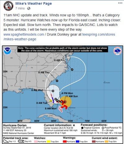
Preparing for Another Hurricane in Good Ol' Fla.

11am update from Mike's weather page...www.spaghettimodels.com

Storm warnings posted on sections of FL east coast...
 

Attachments

  • 11am update.JPG
    11am update.JPG
    80.5 KB · Views: 48
The Tropical Storm warning is now one county over from us.
180 mph is truly unbelievable.
 
Back in 1955-57 when I lived in Okinawa when we had to "hunker down" for a number of very strong tropical cyclones that reached 150+mph. Not many places to go on an island. We even had to ride a large one out in a corrugated metal quonset hut.
The indigenous Okinawan people would use tombs dug into a hillside to stay safe and survive the storm.

https://www.oki-islandguide.com/culture-lifestyle/the-traditional-okinawan-turtleback-tomb


Cheers!
 
I've seen many storms having lived in South Florida all my life. Basically weather predictions are a suggestions on likely events but they are not absolute. The forecast can change up until the last few hours. We thought Andrew was headed to PB County and at the last few hours it turned and hit Miami. I was lucky for my house on that one, but my office in Miami got damaged. I drove supplies down there for a few weeks afterward.
It damaged homes and scared everyone, but I didn't know of anyone actually injured from the storm. Accidents putting up shutters always happen.
I'm as prepared as I can be and will bring my mother to stay here instead of her apartment. It's more that the TV has scared her.
Hoping for the best but as prepared as possible for what could happen. I'm so sorry for anyone in the Bahamas right now. Hoping for the best for all of the Southeast coast.
 
180 mph with gusts to 200, don't see that very often


Very true. One of the Florida meteorologists just said about an hour ago that there are only 1 or 2 storms historically to compare Dorian to, so we are basically in "uncharted territory" as far as predicting what it will do next. The models are pretty good, but they're based at least partly on data inputted from previous storms, so if you only have limited data on storms as strong as this, you can't really expect the model to perform perfectly.


I just hope the shelters in the northern Bahama islands are strong enough to withstand something as brutal as this. I just read that about 70,000 people live on the Abacos, and that roughly 90% of them did not evacuate. Predicted storm surge was 20+ feet, with large waves on top of that. Unbelievable.
 
I'll be in the thick of it. I live in Sebastian. I work in Palm Bay. I've been involved with responding on the fire engine to every hurricane to hit the east coast of Florida for the past 22 years. Just a little bit post Andrew. In addition to flooding and roof/ceiling collapses, we deal with structure fires started from negligent generator use and fuel storage. Carbon monoxide exposure from having the generators placed where they shouldn't be. Medical calls when power is out to oxygen generators, respiratory ventilators or people just flummoxed from not having power in general. It becomes a little more chaotic as communications go down. In the past we have used the mail boxes along the sides of the road as day markers like navigating a channel. I can't say it'll be fun but it will be interesting.
 
This thing needs to start turning. It is nerve wracking watching the persistent west movement.
 
Just listened to Mike's Weather page live. Mike says the NHC predicted track shows a turn initiating at ~2am. We'll have to see.

omni
 
Just listened to Mike's Weather page live. Mike says the NHC predicted track shows a turn initiating at ~2am. We'll have to see.

omni

Yep. I guess I'm nervous because of Irma. Irma was supposed to go right up through center FL. Instead, it stayed west much longer than anticipated, bumped into Cuba, then finally made the turn to go up the west coast of FL. That kind of error for Dorian would be the difference between just off shore (current cone center) and the eye raking the coast (left side cone).

Irma is a recent hurricane with same era computer modelling as Dorian.

Dorian has slowed, so that's a sign it is losing the steering and ready to switch and overnight makes sense to see the change.

BTW, the video on tropical tidbits is also worth watching. He put it out about 2 hours ago. He discusses some interesting things such as if the hurricane slows and weakens (they generally weaken when slowing due to cold water upwell), then the steering current effects are different since the hurricane "stack" shortens. One of the models is seeing this and bumping it west. But ultimately, we have to see.

Basically, the cone is there for a reason. It isn't just the centerline. If you are in the cone, be highly aware.
 
This is the most accurate forecast I have seen.
 

Attachments

  • HurricaneForecast.jpg
    HurricaneForecast.jpg
    58.1 KB · Views: 64
Remember that the cone represents the uncertainty of the forecast track, which is where the storm center is expected to move. The total effects of the storm's wind field will extend beyond the cone.
 
Finally looks like Dorian is turning north. Hope that continues and spares the coast of the Atlantic states.

I know how powerful cat 1-3 storms are from experience. Cannot fathom 180+ mph sustained winds; just sitting on the Bahamas moving 1-3 mph.

Just retired from FPL - one of my departments used to be Emergency Preparedness. All of these brave men and women separated from family who are first responders, restoring power and services are heroes.

Thanks to all those helping others prepare and with the cleanup.

Local, state and federal government agencies can sometimes have dysfunctional relationships that don't become evident until recovery. Fortunately theses people are hurricane experienced in Florida so recovery should be adequate. Sometimes I had been disappointed with interagency bureaucracy, but it has seemed good over the past 14 years.

Media coverage has been good and we appreciate the 24 x 7 coverage. DW and I have to periodically turn off the TV or risk being overcome with anxiety.

DS and DDIL in Daytona and DD in Jacksonville are staying put in their new second floor apartments for the storm, miles from the coast.

Mandatory coastal evacuation means that we are bugging out this morning to a friends house on the mainland.
 
Last edited:
Finally looks like Dorian is turning north. Hope that continues and spares the coast of the Atlantic states.

Not sure what source is for that, but that's contrary to the NHC, as of the 8am forecast (and all prior ones the last 36 hours).

"PRESENT MOVEMENT...W OR 270 DEGREES AT 1 MPH...2 KM/H...Dorian is moving toward the west near 1 mph (2 km/h). A slow westward to west-northwestward motion is forecast during the next
day or so, followed by a gradual turn toward the northwest and
north."

I know everyone has their favorites and facebook links, but I go by the officials only. https://www.nhc.noaa.gov/
 
Best wishes for the continued existence of one another's homes. We fled north to relatives on Friday.

Mandatory coastal evacuation means that we are bugging out this morning to a friends house on the mainland.
 
Not sure what source is for that, but that's contrary to the NHC, as of the 8am forecast (and all prior ones the last 36 hours).

"PRESENT MOVEMENT...W OR 270 DEGREES AT 1 MPH...2 KM/H...Dorian is moving toward the west near 1 mph (2 km/h). A slow westward to west-northwestward motion is forecast during the next
day or so, followed by a gradual turn toward the northwest and
north."

I know everyone has their favorites and facebook links, but I go by the officials only. https://www.nhc.noaa.gov/
That is an instant reading - one particular point in time.

If you look at the recent path, as you can see in the Weather Channel app radar view, the storm is making little jogs north as well as west.
 
Well, as of the 12pm update the NHC is now saying WNW:

PRESENT MOVEMENT...WNW OR 285 DEGREES AT 1 MPH...2 KM/H

So, I'll take that as a start, but I'm not a meteorologist, so I like to go with what they tell me vs. what I think I can see.
 
The state has plans to raise sections of major roads (I-95 for starters) to avoid this in the future. It will take decades, however.

somewhat off topic but hopefully when they raise the I95 they will add 2-3 lanes north and south.
 
The lack of media coverage from the Bahamas is telling. The islands nearest the storm must have been scraped almost clean by the winds.
 
somewhat off topic but hopefully when they raise the I95 they will add 2-3 lanes north and south.
That was mentioned.

NC knows 95 needs to be at least 3 lanes (one direction) from border to border. The problem is funding. Tolls have been mentioned.

Sounds to me like this flooding problem may fast track widening at least some sections when they raise it as a causeway.
 

Latest posts

Back
Top Bottom